How to File Flight Plans for Drones A Practical Guide
Thinking you can just launch your drone anytime, anywhere is a fast track to serious trouble. The skies are getting more crowded by the day, and the discipline of filing a flight plan isn't just about ticking a regulatory box—it's what separates the amateurs from the pros.
For any serious commercial operator, this is the very foundation of a safe, reputable, and profitable business.
Failing to properly file a flight plan can land you with steep fines from the FAA, but the consequences go way beyond your wallet. An unauthorized flight can endanger manned aircraft, wreck your professional reputation, and completely erode the trust you've built with clients. In a market this competitive, people hire pilots who prove their commitment to safety and compliance. A well-documented flight plan is tangible proof that you're one of them.
The New Reality of Crowded Skies
The drone industry's growth is off the charts. As of October 2023, a staggering 855,860 drones were registered with the FAA in the United States alone. This number has surged thanks to expanding commercial uses in sectors like agriculture, construction, and inspections—all of which depend on proper flight planning to stay compliant and safe.
If you want to see just how fast things are moving, check out the latest drone statistics.
This rapid expansion makes organised airspace management more critical than ever. Every professional flight that's properly filed contributes to a safer, more predictable environment for everyone in the air.
The FAA's official Unmanned Aircraft Systems page should be your go-to resource for regulations and updates.

This portal is the central hub for rules, registration, and announcements, making it a must-visit for every pilot to check frequently.
Key Systems for Drone Flight Authorization
This table gives a quick summary of the main systems U.S. drone pilots use for airspace authorization. Use it to quickly find the right tool for your specific flight needs.
| System | Primary Purpose | When to Use It |
|---|---|---|
| LAANC | Near real-time, automated airspace authorization. | For routine flights in controlled airspace below the approved altitude ceilings shown on FAA maps. |
| FAA DroneZone | Manual requests for waivers and complex authorizations. | When your mission is outside LAANC's scope, like needing to fly at night or above standard LAANC altitudes. |
| ATC | Direct coordination for operations in uncontrolled airspace. | For flights near non-towered airports where you need to announce your presence to other air traffic. |
| NOTAMs | Public notices about temporary flight restrictions. | Always check before any flight to be aware of TFRs, like for sporting events, VIP movements, or emergencies. |
Knowing which system to use and when is half the battle. Each one serves a different purpose, and picking the right one from the start will save you a ton of headaches.
Navigating the Systems: A Simpler Path Forward
To get your flights approved, you'll need to get familiar with a couple of key systems. Knowing which tool to use for your specific mission is crucial for getting off the ground quickly.
-
LAANC (Low Altitude Authorization and Notification Capability): This is your best friend for quick, near real-time authorization to fly in controlled airspace around many airports. It’s designed for routine operations below the pre-approved altitude ceilings.
-
FAA DroneZone: When your flight plan is a bit more complex and falls outside what LAANC can handle automatically, you'll head here. This is the portal for applying for authorizations not covered by LAANC or for seeking waivers for specific rules, like flying at night or over people.
Juggling these systems, constantly checking airspace maps, and managing all your project details can become a real grind. This is where a unified platform like Dronedesk makes a massive difference.
By integrating airspace intelligence and flight planning tools directly into your project management workflow, it cuts out a ton of the complexity. Instead of bouncing between multiple apps and websites, you can plan, file, and manage your entire operation from a single dashboard. That saves you valuable time and seriously reduces the risk of making a costly mistake.
Know Your Airspace Before You File
Before you even think about filing a flight plan, you have to get comfortable with reading the sky. Situational awareness isn't just a buzzword pilots throw around; it's the core skill that keeps you compliant, prevents accidents, and marks you as a true professional. Filing a plan without first understanding the airspace you're about to fly in is like trying to navigate a new city with your eyes closed. You're just asking for trouble.
The first thing to get your head around is the difference between controlled and uncontrolled airspace. In a nutshell, controlled airspace is where Air Traffic Control (ATC) services are actively provided. Think of the areas around pretty much any airport, from tiny regional strips to major international hubs. Uncontrolled airspace, known as Class G, is usually found in more remote areas and doesn't have direct ATC oversight, though FAA rules still absolutely apply.
Decoding the Classes
For most drone pilots, the controlled airspace you’ll bump into most often will be Class B, C, D, and E. Each one has its own specific rules, dimensions, and authorization needs, which all directly affect how you file your plan.
-
Class B Airspace: This is the big one. It's the super-busy airspace around the nation's major airports like LAX or JFK. Picture an upside-down wedding cake, with layers of airspace stacked up and out. Flying here requires explicit, direct permission from ATC, which can be tough to get because of all the commercial airline traffic.
-
Class C Airspace: You'll find this around busy airports that have an operating control tower and radar approach control. It's smaller than Class B but still a serious environment. Manned aircraft need two-way radio contact, and drones require mandatory authorization to enter.
-
Class D Airspace: This is a common one for commercial drone work. It typically surrounds airports with a control tower but not quite the traffic levels of a B or C. Authorizations here are very often handled through the LAANC system.
Knowing these classifications isn't just about passing a test. It's directly relevant to the booming commercial drone market, which is on track to jump from USD 12.81 billion in 2025 to a massive USD 27.68 billion by 2032. This explosive growth is built on safe, compliant operations, and that all starts with precise airspace knowledge. You can dig into the numbers in this commercial drone market report.
The Right Tools for the Job
Luckily, you don't need a degree in cartography to figure all this out. Modern tools make assessing airspace incredibly easy, giving you the critical data you need in seconds. The FAA’s own B4UFLY app is the official place to start. It gives you a simple, map-based view of airspace restrictions and any requirements for where you plan to fly.
Many drone operations platforms, including Dronedesk, build these maps right into the workflow. This is a game-changer. It means you can check for controlled airspace, see if there are any Temporary Flight Restrictions (TFRs), and find altitude limits all within your project planning environment. For instance, if you're planning a roof inspection a few miles from a Class D airport, the map will instantly show you the max altitude you can get through LAANC, helping you file a compliant plan without ever leaving the platform.
Pro Tip: Make it a habit to check for TFRs right before you head out to a job. They can pop up with little warning for things like major sporting events, VIP movements, or emergency situations. A TFR can ground your entire operation in an instant, and flying into one without authorization comes with serious penalties.
While apps are fantastic, learning to read the underlying charts is a skill that really sets professionals apart from the crowd. If you want to go deeper, our guide on how to read sectional charts will give you a solid foundation.
Ultimately, mastering airspace is about building a non-negotiable habit. Before every single flight, your first move should be to analyze the sky you plan to occupy. This one step turns filing a flight plan from a reactive chore into a strategic part of every safe and successful mission.
Using LAANC and DroneZone for FAA Approval
Alright, you've figured out your airspace. Now comes the important part: actually filing your flight plan and getting that official green light from the FAA. To do this, you'll be dealing with two main systems: LAANC for the quick, everyday stuff, and the FAA DroneZone portal for more complex missions.
Knowing which one to use is half the battle. Think of LAANC as the express checkout lane for standard flights in controlled airspace. DroneZone, on the other hand, is the full-service counter for everything else. Making the right choice from the get-go will save you a ton of time and hassle.
This decision tree gives you a great visual for picking the right path.
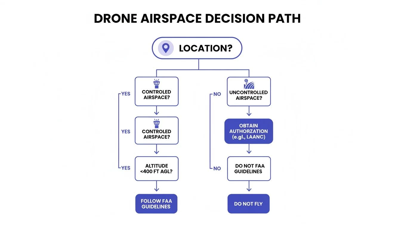
It maps out the basic logic: are you in controlled or uncontrolled airspace? The answer points you directly to the correct FAA system for your authorization.
The Power of LAANC for Instant Authorization
LAANC, which stands for Low Altitude Authorization and Notification Capability, is a genuine game-changer for commercial drone pilots. It’s an automated system that gives you near-instant approval to fly in controlled airspace around hundreds of participating airports. The days of waiting weeks for a human to review a simple flight plan are long gone.
The system works by connecting FAA-approved third-party apps directly with FAA Air Traffic Control data. When you submit a request, the system checks it against pre-approved altitude ceilings for that exact spot. If your plan fits within those limits, you’ll often get your approval in seconds. It’s that fast.
To file a successful LAANC request, you'll need a few key pieces of information on hand:
- Precise Flight Location: You'll define this with a specific address or by drawing a polygon on a map.
- Flight Altitude: This must be at or below the published LAANC grid altitude for that area.
- Radius of Operation: How far you plan to fly from your central point.
- Start and End Times: The specific window for your proposed flight.
- Pilot and Drone Information: This includes your Remote Pilot Certificate number and drone registration.
Real-World Tip: I always advise pilots to request the tightest time window they actually need. Asking for an eight-hour block when the job only takes two hours can tie up airspace unnecessarily and might even draw extra scrutiny. Be precise and realistic.
When FAA DroneZone Is Your Go-To Portal
As efficient as LAANC is, it can't handle everything. It’s built for standard Part 107 operations that fall neatly within the predefined altitude grids. For anything that steps outside those lines, you’ll need to head over to the FAA DroneZone portal.
DroneZone is the FAA's official hub for a much wider range of authorizations and waivers. This is a manual process—an actual FAA official will review your submission—so it takes longer. Expect anywhere from a few days to several weeks, and in some cases, up to 90 days. Plan accordingly.
You'll need to use DroneZone when your mission involves:
- Flying in controlled airspace that isn't LAANC-enabled yet.
- Requesting to fly above the published LAANC altitude ceilings.
- Applying for a waiver to specific Part 107 rules, like night operations (107.29), flights over people (107.39), or Beyond Visual Line of Sight (BVLOS) operations (107.51).
- Seeking authorization for an airspace that requires more detailed, manual coordination.
A Practical Scenario: Construction Survey Near an Airport
Let's walk through a common job. Imagine you’re hired to survey a new warehouse being built two miles from a Class D airport. The highest point you need to inspect is 150 feet AGL (Above Ground Level).
First, you check the FAA’s LAANC grid map for that location. You see the max allowable altitude is 200 feet. Perfect. Since your flight plan is to fly at 150 feet—well below the ceiling—this is an ideal LAANC scenario. You can submit your request through an approved app and you'll likely have authorization in minutes. If you want to dive deeper into these kinds of operations, we have a detailed guide that explains more about airports and drones.
Now, let's change one small detail. What if the client also wants some marketing shots of the site lit up just after sunset? Suddenly, your mission involves night operations, which requires a waiver from Part 107.29.
LAANC can't process waiver requests. This means you have to pivot to the FAA DroneZone portal. Your application will need a detailed safety case explaining how you'll mitigate the risks of flying at night—things like using anti-collision lights and stationing visual observers. This process takes much more time and planning, so you can't just decide to do it on the day. This simple example shows how a single change can completely shift your authorization strategy.
Filing for BVLOS and Other Complex Missions
Moving beyond your standard line-of-sight jobs opens up a whole new world of opportunities. But it also means you have to step up your flight planning game—significantly.
Missions like Beyond Visual Line of Sight (BVLOS), night operations, or flights over people aren't covered by a quick LAANC approval. These complex ops demand a detailed waiver application through the FAA DroneZone, and the burden of proof is entirely on you to show you can operate safely.
This isn't just about filling out a different form; it’s a completely different mindset. You're essentially writing your own safety manual for a specific, higher-risk operation. The FAA needs to see that you've thought through every possible contingency.
The Anatomy of a Successful Waiver Application
When you file for a BVLOS waiver or another complex mission, you're submitting a comprehensive safety case, not just a flight plan. This document is your argument for why the FAA should grant you an exception to the standard rules. It has to be detailed, logical, and backed by solid operational procedures.
Your application must thoroughly address several key areas:
- A Detailed Concept of Operations (CONOPS): This describes exactly what you plan to do, where you'll do it, and the specific equipment you'll use. Be precise about the mission, whether it's inspecting a 10-mile pipeline or conducting a nighttime survey of a large industrial facility.
- Comprehensive Risk Assessment: You need to identify every conceivable risk associated with the mission. Think equipment failure, loss of C2 link, unexpected obstacles, or encounters with manned aircraft. More importantly, you have to detail your specific mitigation strategies for each one.
- Robust Communication Plan: How will the Remote Pilot in Command (RPIC) communicate with visual observers, crew, and potentially Air Traffic Control? Your plan needs to cover primary and backup communication methods.
- Emergency Procedures: What happens when things go wrong? Your plan must outline clear, actionable steps for events like a flyaway, loss of GPS, or a sudden weather shift.
A common mistake I see pilots make is being too vague. Simply stating you'll "use anti-collision lights" for a night waiver isn't enough. You need to specify the make and model of the lights, their visibility range (e.g., 3 statute miles), and how they will be configured on the aircraft to ensure 360-degree visibility.
Real-World Example: Long-Range Pipeline Inspection
Let's say you're tasked with inspecting a 20-mile stretch of pipeline running through a remote, hilly area. A standard visual-line-of-sight flight would be incredibly inefficient, requiring dozens of takeoffs and landings. This is a perfect scenario for a BVLOS waiver.
Your entire flight plan filing process would shift to DroneZone. Your safety case would have to include specifics like the drone's command and control link capabilities, procedures for using visual observers staged along the route, and a plan for how you’ll "see and avoid" other aircraft without having eyes on the drone. You’d also need to prove you have reliable telemetry and video links over the entire distance.
For more details on this topic, check out our guide on BVLOS compliance.
Filing a NOTAM When Necessary
For certain complex missions, especially those that could pose a hazard to other air traffic, filing a Notice to Air Missions (NOTAM) is a critical safety step. A NOTAM is an official alert that informs manned aircraft pilots of potential hazards in a specific location for a set time.
It's a smart move to file a NOTAM if your operation involves:
- Flying at higher altitudes than typical drone flights.
- Operating for an extended period in one area.
- Flying in a location with known low-level air traffic, like agricultural spray planes or helicopters.
You can file a NOTAM through the FAA's official system or by contacting a Flight Service Station. This one action demonstrates a high level of professionalism and shows you're actively contributing to the safety of the national airspace. It proves you’re not just thinking about your own mission, but about your responsibility to everyone else in the sky.
With major FAA and EASA approvals in 2024, BVLOS operations are becoming more common and are expected to make up 25% of commercial drone flights by 2025. This makes these advanced planning and notification procedures more important than ever. You can discover more insights about the future of drone flight planning on sphengineering.com.
How to Streamline Your Flight Plan Workflow
Let’s be honest. After jumping between LAANC, DroneZone, and various waiver application portals, it's pretty clear that the manual process is a massive time sink. Every minute you spend copying and pasting coordinates, double-checking airspace classes, or logging mission details is a minute you're not flying, analyzing data, or actually growing your business.
This scattered approach doesn't just eat up your day; it opens the door to human error. A single wrong coordinate or a missed TFR can get your flight plan rejected—or worse, land you in hot water with a compliance violation. Constantly switching between different systems is inefficient and adds a layer of risk to your operations that just doesn't need to be there. Thankfully, there’s a much smarter way to handle all this.

Unifying Your Operations in One Place
The real solution is to stop relying on a patchwork of single-purpose tools and bring everything into an integrated drone operations platform. A system like Dronedesk pulls every part of your job—from the first client call to the final flight report—into one central dashboard. This isn't just a minor tweak; it fundamentally changes how you file flight plans. It stops being a tedious, separate task and becomes a natural, logical part of managing your project.
Instead of starting from zero with every new mission, all your key data is already in the system. Your client info, site boundaries, team members, and drone maintenance logs are all connected. So, when it's time to plan a flight, the platform just pulls that existing information, pre-filling a ton of what's needed for your submission.
By bringing planning, compliance, and flight execution into a single platform, professional drone operators can cut their administrative time by up to 80%. That’s a huge efficiency gain, letting pilots focus on flight quality and client deliverables, not paperwork.
This kind of integration practically eliminates the redundant data entry that makes manual workflows so painful and significantly reduces the chance of making a costly mistake.
From Client Call to Final Report
To see how this works in the real world, let's imagine a typical job from start to finish. A new client rings you up, needing an urgent roof inspection.
-
Job Creation: First, you create a new job in Dronedesk. You enter the client's details and the site address just once. The system instantly sets up a dedicated project folder for everything that follows.
-
Automated Airspace Intelligence: As you draw the flight area on the map, the platform gets to work, automatically analyzing the airspace. It immediately flags that the site is in Class D airspace and tells you the LAANC altitude ceiling is 150 feet. It even alerts you to a nearby hospital helipad—a critical piece of info for your risk assessment.
-
Risk Assessment and Planning: All the information you need for your risk assessment is right there. Airspace class, potential ground hazards, and mission details are at your fingertips. You can complete your pre-flight checks and document safety procedures inside the same project. No more switching apps.
-
Seamless Filing: Because the platform already knows your location, planned altitude, and operational radius, it has everything it needs for the LAANC submission. You can file your flight plan directly from the project dashboard and often get approval in seconds without ever leaving the system.
The whole process just flows. The flight plan isn't some chore you tack on at the end; it's a direct result of a well-organized project plan. Once the mission is done, your flight logs, photos, and client reports are all stored in that same project folder, giving you a complete, compliant record from start to finish. This approach makes it incredibly simple to file flight plans correctly, every single time.
Common Questions About Drone Flight Plans
Even with a solid plan, questions always seem to pop up right when you're about to file. It happens to everyone. Let's walk through some of the most common ones I hear from other pilots, so you can get your answers and get back to business.
Do I Really Need to File for Every Single Flight?
Not always, but you absolutely have to know when it's required. The rule is simple: if you're flying in controlled airspace—that's Class B, C, D, or the surface area of E—you must have authorization. No exceptions.
Now, for flights out in the middle of nowhere in uncontrolled Class G airspace, a formal filing with the FAA isn't mandatory. That said, if you're running a complex mission or flying near a non-towered airport, filing a NOTAM is still a smart move. It’s a professional courtesy that keeps other pilots in the loop.
How Far in Advance Should I File?
This is a big one, and the answer really hinges on where you're filing and what you're asking for.
- LAANC: For straightforward jobs, LAANC is incredibly fast. You can often get an automated approval in near real-time, sometimes just minutes before you plan to take off. My advice? Still give yourself at least an hour's buffer just in case there are any system hiccups.
- FAA DroneZone: This is the slow lane, because a real person has to review your request. Plan on submitting at least 30 days in advance for most things. If you're going for something more complex like a BVLOS waiver, give them the full 90 days the FAA suggests. Trust me on this.
A classic mistake is underestimating how long DroneZone takes. If a client calls you for a night flight next week and you haven't already filed for the waiver, you’re out of luck. You have to bake these timelines into your client conversations from day one.
What Happens If My Flight Plan Is Rejected?
First off, don't panic. A rejection isn't a final "no." It's usually just the system or a reviewer telling you they need a correction or more information. More often than not, it's a simple fix.
Start by reading the denial reason carefully. It’s usually something straightforward:
- Wrong Coordinates: It's easy to mistype a number. Double-check your latitude and longitude to make sure they perfectly match your flight area.
- Altitude Too High: You might have requested an altitude that’s above the ceiling for that specific LAANC grid. Try lowering it and resubmitting.
- Not Enough Detail on Safety: For waiver requests, a rejection often means your safety case wasn't convincing enough. You'll need to add more detail about how you'll handle specific risks.
Fix the issue they pointed out and send it back through. If you’re in DroneZone, be ready to really flesh out your risk assessments and operational plans to get that approval.
Should I Call the Local Cops?
There's no federal rule saying you have to notify local law enforcement about a Part 107 flight. But from my experience, it's often a very, very good idea, especially if you're flying in a busy urban area or near sensitive locations like schools or hospitals.
A quick, friendly call to the non-emergency line at the local precinct can prevent a lot of headaches. It stops public concern from turning into a 911 call about a "suspicious drone." Explaining who you are, what you're doing, and showing you're a certified professional builds goodwill and lets you focus on the mission without getting interrupted.
Ready to stop juggling multiple apps and simplify your entire flight planning process? Dronedesk integrates airspace intelligence, mission planning, and compliance tools into one seamless platform, cutting down your admin time and reducing errors. Discover how Dronedesk can transform your drone operations today.
 Beyond Visual Line of Sight BVLOS Explained →
 Drone Laws and Regulations Every Team Should Review →
 Current Drone Laws: What Changed in 2026? →
 JARUS SORA Explained in Plain English →
 Drone Visual Line of Sight Rules Explained →
 Drone Regulations Checklist for Commercial Flights →
 Drone Flying Laws: A Practical Guide for Operators →
 CAA UAV Regulations Explained for UK Operators →
 UK SORA Explained for Drone Operators →
 AUS Drone Laws Explained for Commercial Operators →