Drones in Engineering A Modern Project Guide
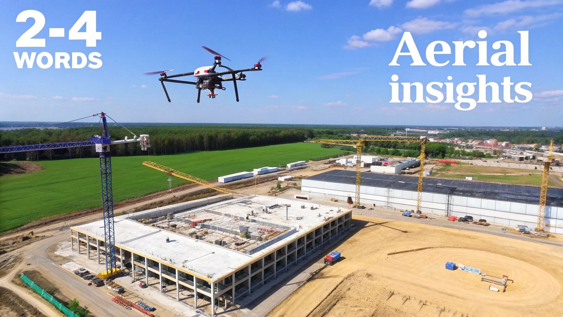
Picture this: you’re managing a massive engineering project, but instead of being stuck on the ground, you have a real-time, bird’s-eye view that catches every single detail. This isn't science fiction. It's the new reality of drones in engineering, where these unmanned aerial vehicles (UAVs) have become indispensable tools for gathering critical data. The insights they deliver are making job sites safer, driving down costs, and dramatically speeding up project timelines.
How Drones Are Redefining Modern Engineering
The days of relying solely on manual surveying crews and risky, hands-on inspections are quickly becoming a thing of the past. Let's be honest, traditional methods, while proven, are often slow and incredibly labor-intensive. It can take weeks to produce a single topographic map, and it often means putting people in harm's way—like scaling a bridge or navigating a busy construction zone. The data you get is accurate for specific points, but it rarely gives you the complete picture needed to manage a modern project effectively.
Drones completely flip that script. Don't think of a drone as just a flying camera; it's more like a Swiss Army knife for data collection. In a single flight, it can cover hundreds of acres, snapping thousands of high-resolution images that software then stitches together into a precise, measurable 3D model of your entire worksite.
A New Era of Data and Insight
This move from manual grunt work to automated aerial data capture gives engineers a level of situational awareness that was previously unimaginable. Instead of working with a handful of data points, they now have a complete "digital twin" of their project. This virtual replica is a genuine game-changer, allowing for smarter, faster decisions right from the office.
This new way of working is empowering teams across different disciplines:
- Civil Engineers can keep a close eye on earthwork progress, calculate stockpile volumes with over 99% accuracy, and confirm that site plans are being followed to the letter.
- Structural Engineers can run detailed facade inspections on buildings and bridges without needing expensive scaffolding or cranes, spotting potential problems from a safe distance.
- Environmental Engineers are now able to map tricky terrain, monitor soil erosion, and check on environmental compliance with far more detail and efficiency than ever before.
Speed, Safety, and Savings
The core benefits here are crystal clear and easy to measure. A land survey that once tied up a team for a week can now be knocked out by one drone operator in a single afternoon. This massive boost in speed doesn't just save time; it slashes labor costs and gets crucial data into the hands of stakeholders much, much faster.
But the biggest win is safety. By taking over dangerous manual inspections—whether it's on a wind turbine, a cell tower, or a steep, unstable slope—drones take people out of high-risk situations. That alone drastically cuts down the potential for accidents and injuries on the job.
At the end of the day, bringing UAVs into your project workflows is no longer a novelty; it’s a competitive necessity. These autonomous systems deliver the speed, safety, and comprehensive data needed to tackle the complexities of modern engineering, setting a whole new standard for how things get done.
Core Applications Across Engineering Disciplines

The practical uses for drones in engineering have exploded, moving way beyond simple aerial photos. These days, they are essential tools woven into the fabric of daily operations, tackling tough challenges that used to drain time, money, and manpower. From chaotic construction sites to far-flung infrastructure, drones are now the go-to for delivering actionable data with impressive speed.
Three fields, in particular, have been completely reshaped by this technology: construction management, land surveying, and infrastructure inspection. Each one puts drones to work in unique ways to boost safety, nail down accuracy, and give project leaders a bird's-eye view of everything. Let's dig into how this plays out in the real world.
Optimizing Construction Site Management
On a sprawling construction project, knowing what's happening day-to-day is everything. The old ways—walking the site or staring at static plans—just don't cut it anymore. They can’t give you the full picture. Drones, on the other hand, offer a dynamic, top-down view that lets project managers see the entire site in one go.
Automated flights allow teams to track progress against blueprints, spot potential hold-ups before they become big problems, and keep the whole operation on schedule. A drone can, for instance, run a quick cut-and-fill analysis to confirm that earthmoving is on track, heading off expensive rework. This constant flow of visual data empowers stakeholders to make smart calls and keep a tight grip on deadlines and budgets. For a deeper dive, check out our full guide on drone use in construction.
This shift toward aerial data is clear in market forecasts. The construction drone market is set to hit USD 4.6 billion in 2025 and is projected to climb to USD 10.3 billion by 2035, growing at a steady clip of 8.4% annually. This boom shows just how much demand there is for real-time site monitoring on projects all over the world. You can find more details about the expanding construction drone market on futuremarketinsights.com.
Accelerating Land Surveying and Mapping
Land surveying has always been a painstaking, boots-on-the-ground job, with teams spending days, sometimes weeks, taking measurements. Drones have flipped that script entirely, capturing huge amounts of topographic data in a tiny fraction of the time.
A single survey drone can cover hundreds of acres in an afternoon, snapping thousands of geotagged images along the way. Using photogrammetry software, these images are then stitched together to create incredibly accurate and detailed maps and models.
- Orthomosaic Maps: Think of these as super-high-resolution, perfectly flat aerial maps—ideal for site planning and analysis.
- 3D Point Clouds: Millions of individual data points come together to form a dense, 3D digital twin of the terrain and any buildings on it.
- Digital Elevation Models (DEMs): These models give you precise elevation data, which is absolutely critical for things like drainage planning and site grading.
This tech lets surveyors produce survey-grade models in a matter of hours, freeing them up to focus on more complex analysis and working with clients.
Enhancing Infrastructure Inspection Safety
Inspecting massive structures like bridges, wind turbines, and power lines is dangerous and costly work. It usually involves rope access crews, scaffolding, or cherry pickers—all of which bring serious safety risks and force operational shutdowns.
Drones offer a much safer, smarter alternative. An operator can stay firmly on the ground while flying a drone equipped with high-resolution cameras right up to hard-to-reach spots. This simple change keeps people out of harm's way while still capturing incredibly detailed images of structural components.
For example, a drone can get up close and personal with the underside of a bridge to look for concrete cracks or inspect a wind turbine's blades for wear and tear. Equip it with a thermal camera, and it can even spot heat anomalies in electrical substations, flagging potential equipment failures before they happen. This proactive approach to maintenance doesn't just improve safety—it extends the life of critical assets.
Drone Applications in Key Engineering Sectors
To put it all in perspective, the table below gives a quick summary of these core applications, showing exactly how drones are delivering value across different engineering sectors.
| Engineering Sector | Primary Drone Application | Key Benefit |
|---|---|---|
| Construction | Progress monitoring and stockpile calculation | Improved project oversight and inventory accuracy |
| Energy & Utilities | Wind turbine and power line inspection | Enhanced safety and proactive maintenance |
| Civil Infrastructure | Bridge and dam structural assessment | Reduced inspection costs and minimal downtime |
By bringing drones in engineering workflows, firms aren't just adopting a new gadget. They're fundamentally changing for the better how projects get planned, built, and maintained.
Understanding the Technology Powering Engineering Drones
So, what really separates a professional engineering drone from that quadcopter you can buy off the shelf? It’s not just the price tag. It’s the incredibly sophisticated tech packed inside. These machines aren't just flying cameras; they’re high-precision data collection tools, built from the ground up to capture information that engineers can actually act on. The hardware and software have to work together perfectly to turn a simple flight into a source of serious project value.
At the core of this are the specialized sensors a drone carries—what we in the industry call its payload. The easiest way to think about a payload is as the drone's "senses." Each sensor is designed to perceive the world in a very specific way, and your choice of sensor dictates exactly what kind of data you can gather and, ultimately, what kind of engineering problems you can solve.
This leap in hardware and software capability is what's fuelling some pretty staggering industry growth. The global market for drone technology is ballooning, with revenues expected to climb from USD 30 billion in 2020 to a massive USD 54.6 billion by 2025. This isn't just hype; it's being driven by real-world efficiencies in massive sectors like construction and infrastructure. You can get more details on these drone industry trends on startus-insights.com.
The Core Sensors in an Engineer's Toolkit
Getting to grips with the main sensor types is key to understanding how drones in engineering can deliver such game-changing results. Each one gathers a unique layer of data, and these layers can be used on their own or stacked together to build a far more complete picture of a site.
-
RGB (Red, Green, Blue) Sensors An RGB sensor is essentially a very, very good digital camera. It captures high-resolution visual data, just like your smartphone, but with vastly superior detail and accuracy. These are the workhorses for creating incredibly detailed orthomosaic maps and 3D models of everything from sprawling construction sites to individual land parcels.
-
LiDAR (Light Detection and Ranging) Sensors If RGB is sight, LiDAR is like the drone's sense of touch—but using light. It works by shooting out rapid pulses of laser light and precisely measuring the time it takes for each pulse to bounce back. This creates what's known as a "point cloud," a dense collection of millions of data points that form a hyper-accurate 3D model of terrain and structures. It's so precise it can even see through vegetation to map the true ground level underneath.
-
Thermal Sensors These sensors don't see visible light; they see the world in terms of heat. By detecting infrared radiation, they generate a heat map that makes them perfect for all kinds of inspections. A thermal camera can instantly spot an overheating electrical component on a utility pole, pinpoint areas of heat loss on a building's facade, or even detect hidden moisture under a roof membrane.
The Software That Brings Data to Life
Getting all that raw data is only half the job. The real magic happens when clever software crunches those thousands of images or millions of laser points into something engineers can actually measure, analyse, and base decisions on. This process relies on two key types of software that form the digital backbone of any serious drone operation.
First up, you have flight planning software. This is your mission control. Instead of flying the drone manually with joysticks like you’re playing a video game, engineers use this software to map out automated, repeatable flight paths. You simply draw a box around your area of interest on a map, set your parameters like altitude and image overlap, and the software creates the most efficient flight plan. The drone then flies it autonomously.
This automated, repeatable process is absolutely critical. It ensures the data you collect on a Monday is captured from the exact same coordinates and angles as the data you collect a month later. This allows for true, apples-to-apples comparison for progress monitoring.
Once the drone is back on the ground, photogrammetry software takes the baton. Think of this as the digital darkroom where the raw data gets developed into usable intelligence. It takes the thousands of overlapping images from an RGB sensor and, through complex algorithms, stitches them together to create a variety of outputs. For a deeper dive into how this works, check out our guide on the essentials of mapping with drones.
This is the software that produces the deliverables that project managers and engineers rely on, like:
- High-Resolution Orthomosaic Maps for site planning and logistics.
- 3D Point Clouds for taking precise measurements.
- Digital Surface Models (DSMs) to visualise topography and structures.
When you put it all together, the hardware and software create an incredibly powerful ecosystem. The drone and its sensors do the heavy lifting in the field, capturing the raw data with unmatched speed, while the software provides the brainpower to process it into the clear, measurable insights that are driving modern engineering forward.
Your Step-By-Step Drone Project Workflow
Running a successful drone operation for an engineering project isn't about just showing up and flying. It’s a disciplined, structured process built for precision and safety. A solid workflow is what turns the complex job of collecting aerial data into a system you can rely on, time and time again.
The whole thing really breaks down into four clear phases. Each one leads into the next, creating a solid chain of command for your data and making sure every part of the mission meets the tough standards engineering and aviation authorities demand. Let’s walk through what that looks like in the real world.
Phase 1 Mission Planning and Compliance
Honestly, the most important work happens before the drone even comes out of its case. This planning phase is the bedrock of the entire operation. It’s where you nail down what you’re trying to achieve, get the lay of the land, and tick every single safety and compliance box. This is way more than just drawing a flight path on a map; it's about thinking through every possible hiccup.
Here's what this stage involves:
- Defining Objectives: Get crystal clear on the "why." Are you running a topographic survey for earthworks calculations? A thermal inspection on a building envelope? Or just a weekly progress flight for the project manager? The goal drives everything—the drone you pick, the sensor you use, and how you fly.
- Site Assessment: Using satellite maps and airspace tools, pilots get a feel for the site. They’re looking for hazards like power lines or cell towers and checking for nearby airports or other no-fly zones.
- Regulatory Checks: This is non-negotiable. You have to confirm you’re compliant with local and national aviation rules. That means checking airspace restrictions, looking for any temporary flight restrictions (TFRs), and making sure all your permits and paperwork are ready to go.
This is where a good management platform like Dronedesk really shines. It can automate things like airspace checks and centralise your risk assessments, so nothing important gets missed.
Phase 2 On-Site Data Capture
With a rock-solid plan, it's time to head to the site and get the data. This phase is all about executing that pre-planned mission with an obsessive focus on safety and accuracy. The pilot isn't just manually flying the drone; they're an operator overseeing a highly automated, precise task.
Out in the field, the team sets up a takeoff and landing zone, places Ground Control Points (GCPs) if survey-level accuracy is needed, and runs through all the pre-flight checks. Once it's in the air, the drone flies the route on its own, snapping thousands of geotagged photos or collecting LiDAR points. The pilot is always watching, keeping an eye on the drone’s systems and the surrounding airspace for anything unexpected.
This methodical approach to data capture is what guarantees consistency. By using automated flight plans, an engineering firm can fly the exact same mission week after week, creating a perfect timeline of project evolution.
Phase 3 Data Processing and Modeling
When the drone lands, its memory card is full of raw data—but that data isn't useful yet. The processing phase is the digital alchemy that turns all those raw files into the maps and models engineers can actually work with. This is where powerful photogrammetry software does the heavy lifting.
The following infographic illustrates the journey from raw data capture to the creation of useful digital models.
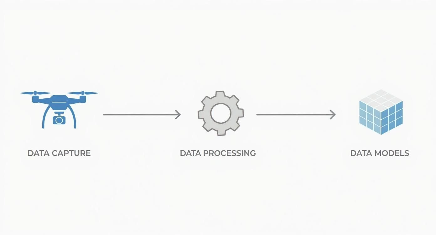 This flow shows how captured images or point clouds are computationally stitched together to produce accurate, measurable outputs.
This part can take hours and needs some serious computing horsepower. The software has to align all the images perfectly to generate dense point clouds, 3D meshes, and orthomosaic maps. These outputs are the final deliverables—the "digital twins" that let you take precise measurements and conduct detailed analysis back at the office.
Phase 4 Analysis and Reporting
The final phase is where it all comes together, turning those processed models into real, actionable insights for the project team. This is where engineers get hands-on with the digital models to run calculations, spot problems, and track how the project is moving along. For instance, they might measure stockpile volumes, check as-built conditions against the original design files, or inspect a bridge for tiny cracks.
The goal here is to package these findings into a report that’s clear and easy to digest for everyone involved, from the site foreman to the client. This could include annotated screenshots, progress charts, and specific recommendations based on what the drone data revealed. By closing the loop with this step, the drone workflow becomes a full-fledged decision-support system that helps drive smarter engineering.
Measuring the ROI of Your Drone Program
Beyond the cool tech and incredible visuals, the decision to bring drones into engineering projects always boils down to one simple question: what’s the business case? For any firm, justifying a new technology means proving its return on investment (ROI). Thankfully, the financial wins from a well-run drone program aren’t just theoretical—they're real, measurable, and often massive.
The most obvious return comes from some serious cost savings. Think about it: traditional surveying and inspection methods are incredibly labor-intensive. They require teams of specialists, expensive gear like cranes or scaffolding, and a whole lot of time on site. A drone can often do the same job with a single certified pilot in a fraction of the time, slashing labor costs and equipment rental fees.
This efficiency directly translates into faster project timelines. What once took a survey crew a full week to map can often be knocked out by a drone in a single afternoon. Getting that crucial data into the hands of project managers and stakeholders sooner means faster decision-making, which is key to keeping projects on schedule and under budget.
Quantifying the Financial Gains
To get to a true ROI, you have to look past the direct cost cuts. The real value is also in risk mitigation and the sheer quality of the data. Sending a drone up to inspect a bridge or a wind turbine means a human doesn't have to work at dangerous heights. That alone can lead to a huge reduction in insurance premiums. Honestly, the cost of preventing just one workplace accident can often justify the entire drone program.
By capturing a complete, high-resolution picture of an entire site, engineering teams can spot potential problems—like design clashes or safety hazards—long before they turn into expensive rework orders. This proactive problem-solving delivers immense financial benefits, even if they're a bit harder to stick on a spreadsheet.
The rapid growth of the global commercial drone market really tells this story. The entire drone ecosystem was valued at around USD 40.6 billion in 2025 and is on track to hit USD 57.8 billion by 2030. That's a crystal-clear sign of strong demand across the board. You can find more insights about this drone market growth on droneii.com.
A Practical ROI Example
Let's imagine a large-scale construction project that needs monthly topographic surveys to track earthwork progress.
- Traditional Method: A three-person survey crew spends four days on site. The cost? Roughly $12,000 in labor and equipment.
- Drone Method: A single drone pilot finishes the survey in about five hours, with data processing taking another half-day. The total cost, including the pilot's time and software, comes out to around $2,500.
In this scenario, the monthly saving is a whopping $9,500. Over a two-year project, the total savings would pile up to $228,000. That easily covers the initial investment in hardware, software, and training several times over. When you're ready to present these benefits and ask for investment, it's vital to know how to create a compelling pitch deck that lays out these returns clearly.
To track these numbers accurately, you need to be monitoring the right metrics. You can learn more about how to measure these operational efficiency metrics in our detailed guide. By putting real numbers to the time savings, cost reductions, and safety improvements, engineering firms can build an undeniable business case for adopting drone technology.
Got Questions About Drones in Engineering? We've Got Answers.
Even when the benefits and workflows are clear, taking that first step to bring drones into your engineering practice can feel like a leap. It’s completely normal to have questions about regulations, data accuracy, how to structure your team, or what's next with new technology.
This section tackles the most common questions we hear from engineering pros head-on. The goal is to give you straightforward, practical answers so you can move forward with confidence.
What Are the Biggest Hurdles When Starting a Drone Program?
Getting a drone program off the ground is about much more than just buying the latest hardware. From what we've seen, the main challenges engineering firms run into fall into three buckets: wrestling with aviation rules, building solid safety protocols, and figuring out how to manage the sheer volume of data drones produce.
First, you’ve got to get your pilots certified by the local aviation authority, which means training and getting a firm grip on airspace regulations. After that, it's about developing your own Standard Operating Procedures (SOPs) and doing a thorough risk assessment for every single flight. This isn't just best practice; it's essential for safety and staying on the right side of the law.
On the other side of the coin is the data itself. A single project can generate terabytes of image and LiDAR data. That requires some serious computing power and specialized software to process. You also need people with the right skills to turn all that raw information into actionable engineering insights.
This is exactly where modern drone management platforms like Dronedesk come in. They are built to solve these problems by centralizing compliance documents, automating flight plans, simplifying risk assessments, and keeping project data organized. It just makes the whole workflow much more manageable and scalable for any engineering team.
Just How Accurate Is Drone Survey Data?
When you’re talking about surveying and mapping, accuracy is non-negotiable. The good news is that with the right gear and methods, drone data is remarkably precise. In fact, it often meets or even beats the standards of traditional ground-based surveying, getting you down to centimeter-level accuracy.
This incredible precision comes from advanced GPS technologies built right into the drones.
- Real-Time Kinematic (RTK): Think of this as a live fact-checker. A fixed station on the ground sends real-time corrections to the drone as it flies, allowing it to fix its position on the fly. This results in incredibly accurate location tags for every photo.
- Post-Processing Kinematic (PPK): With PPK, the drone and a separate base station record their own GPS data. After the flight, the two datasets are crunched together to hit that same centimeter-level accuracy. It’s a great option for areas where radio signals might be spotty.
To really dial in the accuracy, surveyors also use Ground Control Points (GCPs). These are just marked targets on the ground with coordinates that are known to be exact. They act as anchors to fine-tune the final model. The result is orthomosaic maps and 3D models that aren't just precise—they're far more detailed and complete than anything you could get from traditional methods, giving you a true digital twin of the site.
Should We Hire a Dedicated Pilot or Train Our Own Engineers?
This is a big strategic question, and honestly, there's no single right answer. Both hiring a specialist and training your current team are perfectly good routes to take. The best path for you really hinges on how often you plan to fly.
Many engineering firms find huge value in upskilling their existing technical staff. When you train your own surveyors, project managers, and inspectors to become certified pilots, you get one massive advantage: they already know what they're looking for. They have the project knowledge to interpret what they're seeing in real-time, which leads to smarter flights and better data.
For smaller firms or those who just need aerial data once in a while, bringing in a specialized drone service provider can be more cost-effective at the start. But as drones in engineering become a core part of your daily work, building an in-house team almost always pays off. It gives you more flexibility, tighter control over your data, and saves a lot of money in the long run.
What’s the Deal with AI and Engineering Drone Data?
Artificial intelligence (AI) and machine learning are quickly becoming game-changers for analyzing the mountains of data drones collect. Think of AI as a force multiplier—it automates tedious tasks that would take a human countless hours to do by hand. Instead of an engineer sifting through thousands of individual photos, an algorithm can do the heavy lifting.
For example, you can train AI models to automatically spot and classify specific things with stunning speed and accuracy.
- On a bridge inspection, AI can pinpoint and flag hairline cracks in concrete.
- In a logistics yard, it can run an automated count of all your assets.
- On a construction site, it can track progress against the project schedule.
Machine learning pushes this even further by making predictive analysis possible. You can train models to see patterns that signal future problems, like highlighting areas on a job site with a higher risk of safety issues or monitoring vegetation growth near power lines to head off outages. This kind of automation doesn't just speed up analysis; it cuts down on human error and helps you find deeper, more valuable insights in the data you're already collecting.
Ready to manage your entire drone operation from a single, powerful platform? Dronedesk simplifies everything from flight planning and compliance to team and fleet management, ensuring every mission is safe, efficient, and profitable. See how Dronedesk can transform your workflow today.
 Drone Near Airport Rules Explained for Safer Planning →
 International Drone Regulations Every Global Team Should Know →
 Drone Flight Risk Assessment Example for Safer Missions →
 Beyond Visual Line of Sight Explained for Operators →
 How BVLOS Drone Operations Change Commercial Workflows →
 FAA Drone Rules Every Commercial Pilot Should Know →
 FAA 107 Explained for Commercial Drone Operators →
 Canadian Drone Regulations Explained for Business Use →
 FAA Part 107 Drone License Explained for Beginners →
 How to Review a DJI Drone Flight Log Step by Step →