Mastering Digital Aeronautical Flight Information File
If you're planning drone jobs across more than one site, you already know the friction. One app shows controlled airspace. Another has NOTAMs. A PDF holds a local procedure. A separate map helps with obstacles, but only in one country. Then the crew lead asks a simple question: do we have one current, defensible view of the airspace picture for this mission?
That's the practical problem behind the phrase digital aeronautical flight information file. Most operators don't need a history lesson first. They need a reliable way to turn scattered aeronautical data into a go or no-go decision, a safe route, and a clean audit trail.
For professional drone teams, this isn't just about convenience. Bad source selection creates avoidable risk. You can brief from the wrong boundary, miss a temporary restriction, or rely on a community map that looks complete but isn't authoritative. The fix is understanding how digital aeronautical data is structured, where it comes from, and how to manage it in day-to-day operations.
The Challenge of Modern Flight Planning
Modern drone flight planning often feels less like planning and more like reconciliation. You check official notices, compare map layers, verify local restrictions, review terrain and obstacles, and then try to make all of that usable for a pilot in the field. The problem isn't lack of data. It's that the data lives in different places, changes on different schedules, and arrives in formats that aren't designed for quick operational decisions.
That fragmentation isn't unique to aviation. It shows up in every industry that moved from paper processes to digital coordination, and these 10 digital transformation examples for 2026 are a useful reminder that the hard part usually isn't collecting information. It's making separate systems produce one operationally useful workflow.
For drone teams, the operational impact is immediate. A planner may build a route from one map, check restrictions on another, and send a mission brief that still requires the field pilot to revalidate key details. That creates duplicated effort and inconsistent judgment. If your team is refining that process, this guide to best flight planning for drone operators is worth reviewing alongside your own SOPs.
What operators actually need
The ideal isn't complicated. You want a single source of truth for the mission area that combines:
- Airspace structure: controlled airspace, special use areas, and relevant boundaries
- Operational restrictions: notices, temporary limitations, and short-notice changes
- Ground risk context: obstacles, terrain, launch constraints, and nearby sensitive locations
- Usable presentation: the information has to reach the pilot in a form they can act on quickly
That ideal is what many people are really asking for when they search for a digital aeronautical flight information file. They aren't only asking what DAFIF was. They're asking whether anything today plays the same unifying role.
Practical rule: If your pre-flight process requires a pilot to mentally merge five disconnected data sources, your workflow is carrying risk that software and source discipline should remove.
Why the old idea still matters
The phrase still matters because it points to a real operational need. Aviation works better when aeronautical information is standardized, current, and easy to consume. Drone teams feel the absence of that standardization more sharply when they work across borders, run multiple crews, or need to prove that a planning decision was based on current information at the time of flight.
Decoding the Digital Aeronautical Flight Information File
A crew planning cross-border work quickly learns the difference between having data and having usable aeronautical information. One source covers airspace geometry, another carries airport reference data, another handles notices, and each has different update cycles and terms of use. DAFIF mattered because, for a long period, it reduced that fragmentation.
Historically, DAFIF meant the Digital Aeronautical Flight Information File, a worldwide digital aeronautical database managed by the U.S. National Geospatial-Intelligence Agency, as outlined in the DAFIF historical overview. Its value was practical. It assembled structured flight information on airports, airways, airspace, navigation facilities, and other reference data that planning systems could ingest and use at scale.

For operators, that meant less manual stitching. Software vendors did not have to build every country from separate public documents, and flight teams had a more consistent base layer for route planning, airspace interpretation, and nav reference checks.
What was inside it
In DAFIF terms, a digital aeronautical flight information file pulled together the core objects flight systems rely on. Airports, airways, airspace definitions, navigation points, and related reference records all sat in one structured dataset.
For a drone team, the useful distinction is simple. This was machine-readable aeronautical data, not just a chart image or a PDF briefing pack. Systems could query identifiers, coordinates, boundaries, frequencies, relationships, and attributes directly. That is the difference between reading aviation information and integrating it into a flight planning workflow.
Teams that want the operational context behind that shift should review this guide to aeronautical information management workflows and standards. It connects older centralized datasets to the publication and exchange methods used now.
Why its withdrawal mattered
Public access to DAFIF ended in the mid-2000s, and that changed the aeronautical data market in a lasting way. The immediate issue was not nostalgia. It was workflow impact. A widely used common dataset was no longer available to the broader ecosystem, so vendors, operators, and service providers had to assemble coverage from other sources with different scope, licensing, and update processes.
That is one reason international planning still feels uneven. Two tools can both claim aeronautical coverage and still differ materially in what they include, how quickly they reflect change, or how cleanly they model the source data.
DAFIF set a benchmark for what operationally useful aeronautical data looks like. Broad coverage, consistent structure, and predictable reuse.
The practical takeaway for drone teams
For modern drone operations, DAFIF is less a current product than a reference point. It shows why fragmented inputs create friction in daily planning and why source governance matters. If your team checks controlled airspace in one system, local procedures in another, and temporary restrictions somewhere else, the risk is not only missing data. The risk is making a correct decision from an incomplete picture.
That is why teams using platforms such as Dronedesk still need to ask disciplined questions about source origin, coverage limits, update timing, and how separate feeds are reconciled before a mission goes live. The old DAFIF model did not remove operational judgement, but it did reduce the amount of data assembly required before that judgement could be applied.
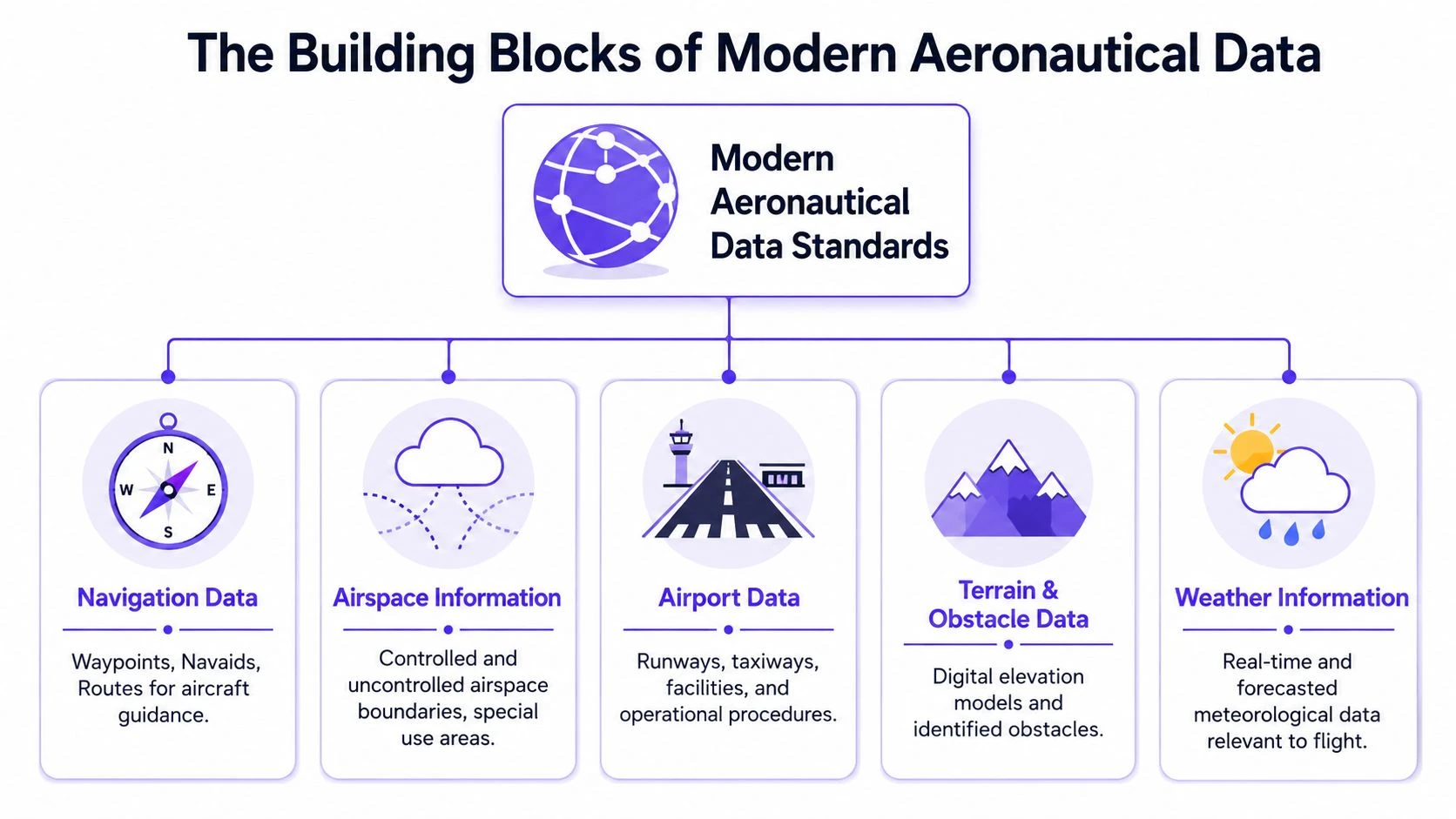
The Building Blocks of Modern Aeronautical Data
Today's aeronautical systems don't usually revolve around one public global file. They revolve around data models, exchange formats, and publication workflows that let many systems share aviation information. For drone teams, the important point isn't memorizing standards acronyms. It's understanding that your software only works well when these standards are translated correctly into operational views.
Think of modern aeronautical data as a shared language. One authority publishes a change. Another system ingests it. A planning platform renders it on a map. A pilot sees a restriction shaped and labeled in a way that matches the underlying source. When that chain works, decisions get faster and safer.
AIXM and structured aeronautical data
AIXM stands for the Aeronautical Information Exchange Model. In practical terms, it's a structured way to describe aviation data so different systems can interpret the same underlying information consistently.
That matters because aviation data isn't just points on a map. An airspace object may have vertical limits, activation conditions, time applicability, geometry, and relationships to other published information. If your platform can't handle that structure well, the display may look tidy while the interpretation is weak.
AIXM becomes relevant to drone operators whenever a system claims to aggregate official aeronautical information. The quality difference often comes down to whether the platform preserves the meaning of the source or just converts it into a simplified visual layer.
Digital NOTAMs and what they change
NOTAMs are operational change notices. A digital NOTAM approach tries to express those notices in structured data rather than only in text that a human has to parse manually.
That distinction matters in the field. Free-text notices can be hard to read quickly and easy to misinterpret, especially when they affect narrow time windows or small geographies. Structured notices are easier for software to filter by location, time, and mission type.
A practical way to think about NOTAM handling is this:
- Raw text is necessary: pilots and planners still need the original notice context
- Structured interpretation is better for workflow: software can flag what is likely relevant to your mission area
- Human review remains essential: good tools reduce noise, but they don't remove operator responsibility
A clean map layer is not the same as a correctly interpreted notice.
Digital AIP and published reference material
The Aeronautical Information Publication, or AIP, is the durable reference layer of aviation information. Where NOTAMs capture changes and short-notice issues, the AIP carries more stable published rules, procedures, and descriptions.
In digital form, AIP content becomes easier to search, ingest, and cross-reference with maps and planning tools. For drone operators, this is often where local procedure detail lives. The challenge is that each country may publish and structure that information differently.
What a drone team should watch for
When you're choosing tools or building internal planning SOPs, ask practical questions rather than technical vanity questions.
| Check | Why it matters in operations |
|---|---|
| Can the system show source provenance? | You need to know where a restriction or boundary came from |
| Does it handle time-based changes well? | Temporary activations and short-lived notices can affect launch decisions |
| Can planners and pilots see the same interpreted data? | Misalignment between office planning and field execution creates avoidable risk |
| Does the map reflect structured aviation objects or just generic overlays? | Generic overlays can hide important detail or context |
The strongest workflow is usually not the one with the most layers. It's the one where each layer has a clear purpose, a clear source, and a clear operational owner.
From Raw Data to Flight Plan A Practical Workflow
A drone crew planning a job near controlled airspace rarely struggles because data is unavailable. The true challenge lies in turning scattered, differently formatted aviation information into a decision the pilot can trust before launch.
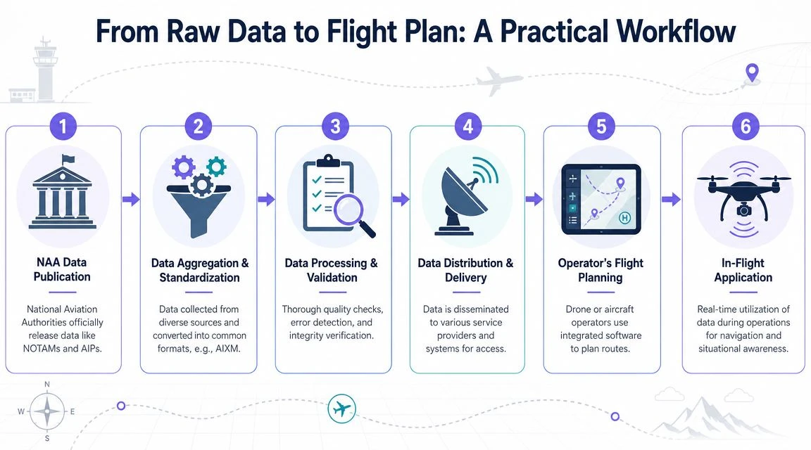
Raw aeronautical data usually arrives in pieces. An authority publishes a chart amendment, a digital notice, an obstacle update, or AIP material. A data provider then converts those inputs into structured records that software can query, map, and filter. Only after that processing step does the information become usable in an operational tool.
For drone teams, that middle layer matters more than it first appears. If the processing is weak, the map may still look clean while the underlying interpretation is wrong, incomplete, or out of date.
How the data moves
A practical workflow usually looks like this:
-
Publication by the authority
The aviation authority issues source material such as airspace definitions, procedure data, obstacle records, or notices that affect operations. -
Collection from official channels
A provider pulls that material from one or more state or regional sources. At this point, structure and terminology often vary by jurisdiction. -
Normalization and quality checks
The provider converts source formats into a consistent internal model and checks for missing attributes, broken geometry, duplicate features, conflicting effective times, and plain transcription errors. -
Delivery into operational software
Planning tools ingest the processed dataset and connect it to map layers, airspace warnings, mission areas, and approval workflows. -
Operational review by the team
The planner or remote pilot looks at what affects the specific site, time, and aircraft profile, then decides whether the mission can proceed as planned, needs controls added, or should be delayed.
Each step can introduce risk.
Where workflows break down
The common failure points are operational, not academic:
- Format mismatch: one authority publishes structured digital data, another relies heavily on PDFs or text that still needs interpretation
- Coverage gaps: a source may be authoritative for obstacles but weak for temporary restrictions, or strong domestically but thin across borders
- Timing drift: one feed updates quickly while another lags, and the software may not make that gap obvious to the operator
- Display simplification: a system may reduce a conditional restriction to a generic polygon and hide altitude limits, activation times, or approval conditions
This is one reason older unified datasets were so useful to flight planning vendors. As noted in AOPA's brief on the discontinuance of public sales of Defense Department aeronautical charts and databases, once a dependable aggregated source disappears, the burden shifts to software providers and operators to rebuild coverage from multiple inputs.
Drone teams now face that same practical reality. The task is not to find one perfect file. It is to use tools and procedures that combine sources carefully, preserve provenance, and make the final planning view usable in the field.
What good processing looks like
A useful processing layer does three jobs well.
-
Preserves operational meaning
Controlled airspace, temporary restrictions, obstacles, and procedure notes need to stay tied to their actual conditions, not reduced to vague map coloring. -
Cuts planning workload
The crew should be able to filter by location, date, and mission profile instead of manually reading every publication that might apply. -
Supports traceability
If an incident, audit, or client question comes up later, the team should be able to show what source was used, when it was current, and how it was interpreted.
That is the standard to expect from modern planning software, including platforms such as Dronedesk. The value is not the map alone. The value is the controlled handling of messy source material before it reaches the pilot screen.
Field advice: If your team cannot explain how a restriction moved from the authority publication into the flight planning view, treat that gap as an operational risk and verify the source before launch.
Implementing Digital Data in Your Drone Operations
The practical challenge today is fragmentation. Authoritative aeronautical information is often country-specific, and substitutes don't line up neatly. The FAA's Digital Obstacle File primarily covers the U.S. with limited spillover into the Pacific, Caribbean, Canada, and Mexico, while community sources such as OurAirports may help fill gaps but are not authoritative, as reflected in the FAA's Digital Obstacle File information.

That means drone teams need a method, not just a map. You won't rebuild a modern digital aeronautical flight information file by downloading random datasets. You rebuild the useful part of it through source discipline, validation steps, and software that reduces manual stitching.
Build a source hierarchy
Start by classifying sources before you classify risk areas. Teams often do this backward.
A workable hierarchy looks like this:
- Primary sources: national aviation authorities and official publications for the jurisdiction you're flying in
- Operational platforms: tools that aggregate official material and present it in a usable planning interface
- Supplemental sources: local site intel, client-provided maps, and community datasets used only for context, not authority
The rule is simple. If two sources conflict, the more authoritative source wins. If a source cannot show its provenance clearly, treat it as supplemental.
Use a repeatable pre-flight data check
For commercial operations, a repeatable pre-flight review is more valuable than an encyclopedic one. A strong workflow usually includes:
-
Define the mission footprint
Confirm launch point, operating area, altitude intent, nearby structures, and expected recovery area. -
Review controlled and special airspace
Check the mission area against current airspace boundaries and any special-use limitations that could affect the job. -
Check time-sensitive notices
Review relevant notices and temporary restrictions close to launch, not just during the original planning window. -
Assess obstacle and terrain context
Don't rely on one layer blindly. Obstacle coverage can vary by country and by dataset. -
Document the decision basis
Save the planning output, screenshots if needed, and the record of who approved the mission.
Where platforms help and where they don't
Software earns its place when it reduces interpretation work without hiding source quality. An integrated operations platform can centralize mission planning, pilot records, flight logs, and airspace review so the team works from one operational record instead of passing screenshots around.
One example is Dronedesk, which combines drone operations management, flight planning, logging, team workflows, and airspace and proximity intelligence in one system. For a professional team, that matters less as a convenience feature and more as a control feature. Planning, execution, and recordkeeping stay connected.
Still, no platform removes the need for judgment. If you're operating in a country with limited digital publication maturity, your software may surface only part of the picture. In those cases, crews need a local validation step built into the SOP.
Don't ask whether one app has everything. Ask whether your workflow makes gaps visible before launch.
A field-ready operating model
The teams that handle fragmented data best usually adopt a simple model:
| Role | Main responsibility |
|---|---|
| Planner | Builds the mission area, checks formal restrictions, and prepares the flight pack |
| Pilot in command | Validates live conditions, confirms notices still apply as expected, and accepts or rejects the launch |
| Operations lead | Maintains source policy, approved tools, and evidence retention standards |
That division keeps the workload realistic. It also prevents the common failure mode where everyone assumes someone else verified the critical layer.
Ensuring Data Integrity and Operational Compliance
Commercial drone operations need more than a plausible-looking map. They need current, authoritative, and traceable aeronautical information. If an incident, complaint, or regulator question comes later, "the app looked fine" isn't a defensible standard.
Data integrity starts with provenance. Your team should know where the airspace layer came from, when it was last refreshed, and whether it is official, derived, or community-maintained. If that chain is blurry, operational confidence should drop immediately. Strong record discipline matters just as much in planning as it does in maintenance, and this piece on maintenance of data in drone operations is a useful companion for teams tightening internal controls.
Why public maps create professional risk
Public maps can be useful for orientation. They are not automatically suitable for commercial decision-making. The problem isn't that they are always wrong. The problem is that they may be incomplete, stale, or weakly sourced, and the operator often can't tell which.
That becomes a liability when you're managing client sites, multiple pilots, or regulated work. A crew member needs to know not only what the map shows, but why the team trusts it.
A compliance mindset that works
A practical compliance posture looks like this:
- Use authoritative data first: treat unofficial sources as context, not decision authority
- Verify currency: check that the information is current for the planned time of operation
- Retain evidence: keep the planning record that supported the launch decision
- Standardize approvals: define who can accept source ambiguity and under what conditions
Good data management is part of flight safety, not back-office administration.
The teams that stay resilient are the ones that treat aeronautical data as an operational asset. They don't just consume it. They govern it.
Dronedesk helps professional drone teams keep planning, flight records, team workflows, and compliance evidence in one operational system. If you're trying to reduce the friction of scattered tools while keeping a clearer record of how missions were planned and flown, it's worth exploring Dronedesk.
 Drone Flying Laws: A Practical Guide for Operators →
 CAA UAV Regulations Explained for UK Operators →
 UK SORA Explained for Drone Operators →
 AUS Drone Laws Explained for Commercial Operators →
 Drone Flying Rules Explained for Business Use →
 How to Choose an Aerial Survey Drone for Accurate Data →
 What Makes a Great Drone Operator in 2026? →
 Drone Rules Every Commercial Operator Should Know →
 How to Use a Drone Flight Restrictions Map Safely →
 Drone as a Service: Is DaaS Right for Your Business? →