Aerial Survey Pilot: Your A-Z Guide to a High-Tech Career
You’re probably in one of two places right now.
Either you’re a pilot looking for work that isn’t airline track, and you’ve noticed aerial survey jobs keep showing up with vague requirements and oddly specific flying skills. Or you already fly drones, inspections, or mapping work, and you can see the market shifting toward operators who understand both aircraft and data.
That’s where the modern aerial survey pilot sits. It’s still a flying job. But it’s also a planning job, a systems job, and increasingly a data job.
The people who last in this field aren’t just good stick-and-rudder pilots. They learn to fly repeatable lines, protect data quality, work around weather and terrain, speak clearly with surveyors and analysts, and adapt when the platform changes from a piston single to a fixed-wing drone or a hybrid workflow. If you can do that, this career opens up into mapping, mining, utilities, wildlife, construction, corridors, emergency response, and environmental work.
What Is an Aerial Survey Pilot
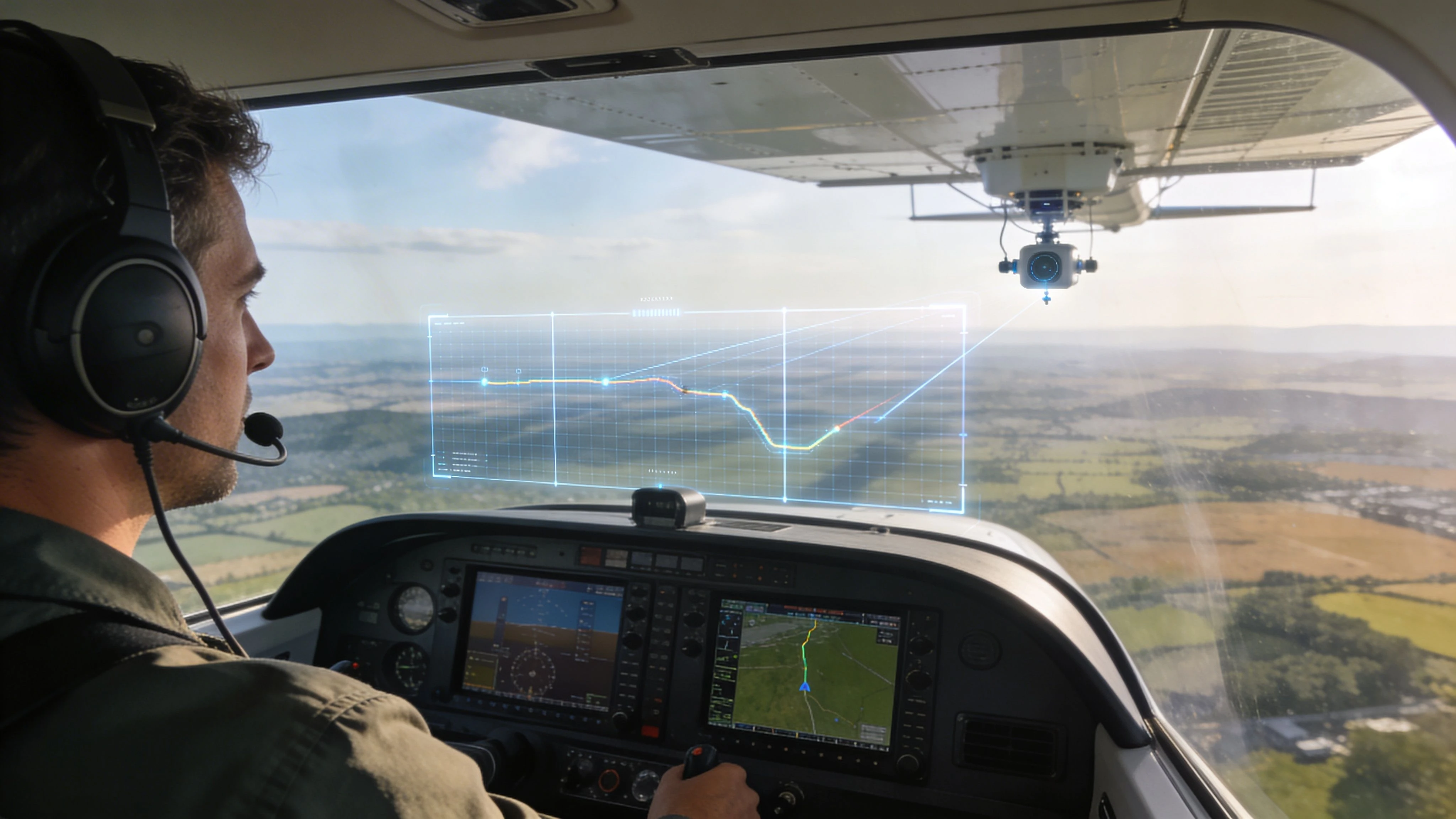
An aerial survey pilot flies to collect usable geospatial data, not to move passengers from one airport to another.
That difference matters. In survey work, the flight itself is only one part of the job. The product is the imagery, point clouds, thermal record, multispectral dataset, or wildlife count that a client will use to make decisions on the ground.
The job is precision, not sightseeing
A good aerial survey pilot holds altitude, speed, line spacing, and timing inside tight tolerances. You don’t improvise much. You execute.
On one mission that might mean flying long, straight mapping lines for photogrammetry. On another, it might mean slow wildlife transects, utility corridor work, shoreline imaging, or repeated passes over a construction site for progress records.
The role has deep roots
This isn’t a new niche created by drones. It’s one of aviation’s older practical jobs.
Aerial survey piloting traces its origins to the American Civil War, when photographers in hot air balloons captured reconnaissance images of enemy positions. It developed quickly after that. Sherman Fairchild’s aerial map of Manhattan in the 1920s proved faster and cheaper than ground surveys, which helped commercialize the field. By the 1980s, turbine aircraft such as the Twin Commander and Cessna Conquest II had become standard platforms for faster modern operations, as outlined in this history of aerial surveying.
Survey flying rewards the pilot who likes discipline. If you need constant variety in the cockpit, this won’t suit you. If you like accuracy and mission focus, it often fits very well.
Where the work sits today
The modern aerial survey pilot works in the space between aviation and measurement.
Typical clients include:
- Survey and engineering firms that need orthomosaics, terrain models, or corridor imagery
- Mining and aggregates teams that need stockpile and site data
- Construction and infrastructure operators tracking progress and earthworks
- Environmental and wildlife agencies running counts, habitat work, or monitoring programs
- Utilities and inspectors gathering visual, thermal, or asset-condition data
The big shift is that the pilot is no longer just “the one who flies.” In many operations, the pilot also needs to understand mission design, sensor limits, file handling, quality control, and how the data will be processed after landing.
Your Path to the Cockpit Qualifications and Career Steps
The path into aerial survey is less mysterious than it looks, but it’s rarely linear.
Few pilots go straight from training into a premium survey seat. They build toward it in stages. The pilots who move fastest usually stop chasing generic hours and start building relevant hours.
Start with the right certificates
For manned survey flying, the baseline is the same as other professional flying jobs. You need a commercial path, and you’ll usually make yourself far more employable if you add instrument capability.
If you’re still early in training, a solid overview of how to become a commercial pilot helps frame the traditional route from student pilot to paid flying.
For drone work, the legal path depends on where you operate, but the principle is the same. Get the credential that lets you work commercially, then build operational competence, not just a card in your wallet. If you’re coming in from the drone side, this guide on becoming a commercial drone pilot is useful: https://blog.dronedesk.io/how-to-become-a-commercial-drone-pilot/
The low-time pilot problem is real
Many new pilots get stuck here.
Forum discussions show pilots with 200-300 hours often aren’t clear on what survey employers want, while anecdotal reports suggest 500-1,000 hours is often needed for manned pilot-in-command survey roles. Some companies do hire sensor operators as an entry point, which can help bridge that gap, as noted in this discussion on aerial survey gig entry requirements.
That doesn’t mean low-time pilots are shut out. It means you need a strategy.
What kind of experience actually helps
Survey operators care less about glamorous hours and more about whether you can fly accurately, consistently, and professionally.
A useful profile often includes:
- Instrument proficiency: Survey schedules don’t wait for perfect VFR patterns every day. Instrument training improves scan, discipline, and workload management.
- Precision flying: Holding line, altitude, and speed matters more here than showing off hand-flying flair.
- Rural and remote ops comfort: Many jobs start away from major airports, with fuel planning and field logistics that are less forgiving.
- Systems discipline: You’ll work around cameras, mounts, mission software, data cards, checklists, and repeatable procedures.
- Crew mindset: Some survey pilots work closely with camera operators, observers, GIS staff, or field teams. Good communication counts.
Practical rule: Build hours that prove control and judgment. Employers notice a pilot who can fly repeatable profiles and make calm decisions. They don’t care much that you once shot a perfect short-field landing in front of your friends.
The realistic first jobs
Many pilots enter through support roles before they get a captain seat in a survey platform.
Common entry points include:
-
Sensor operator or camera operator
This teaches workflow, line discipline, client requirements, and how bad data gets created. It’s one of the best ways to learn the business from inside the aircraft. -
Smaller survey firms
Smaller operators often need flexible people. You may help with preflight setup, flight planning, data handling, and ferry segments, not just flying. -
Drone mapping and inspection work
This route is underrated. Drone operators who understand overlap, terrain, georeferencing, and deliverables often transition well because they already think like data collectors. -
Other commercial flying that sharpens precision
Ferry work, patrol, instruction, skydive flying, and utility support can all help if they build judgment and cockpit consistency.
Career progression usually looks like this
The broad pattern is straightforward, even if the details vary by country and employer.
| Stage | Typical focus | What you need to prove |
|---|---|---|
| Early training | Certificates, ratings, basic professionalism | You can train efficiently and safely |
| Entry support role | Sensor ops, logistics, light flying, drone work | You understand mission workflow |
| Initial survey pilot role | Simpler platforms, shorter lines, lower complexity jobs | You can deliver repeatable data capture |
| Advanced survey role | Complex terrain, larger projects, specialized sensors | You can manage risk, crew, and quality together |
| Operations lead | Scheduling, standards, fleet, clients, quality systems | You can run profitable missions, not just fly them |
Skills that move you up faster
A few habits separate the pilot who stays “just current” from the one who becomes hard to replace.
Learn to brief like an operator
If you can explain line layout, weather risk, fuel plan, sensor setup, and contingency actions clearly, clients and managers trust you faster.
Understand the payload
You don’t need to be a software engineer, but you do need to know what the sensor needs from your flying. Survey pilots who ignore the data side limit their own ceiling.
Get comfortable with repetitive work
Aerial survey can be mentally demanding because it looks simple from the outside. Straight lines for hours can wear down attention if you haven’t built good cockpit routines.
Be easy to deploy
Operators value pilots who can pack, reposition, adapt to a field base, and work cleanly with maintenance and ground teams.
The shortest version is this. Get qualified. Build disciplined hours. Take the support role if that’s what opens the door. Then become the pilot who protects data quality, not just airspeed and heading.
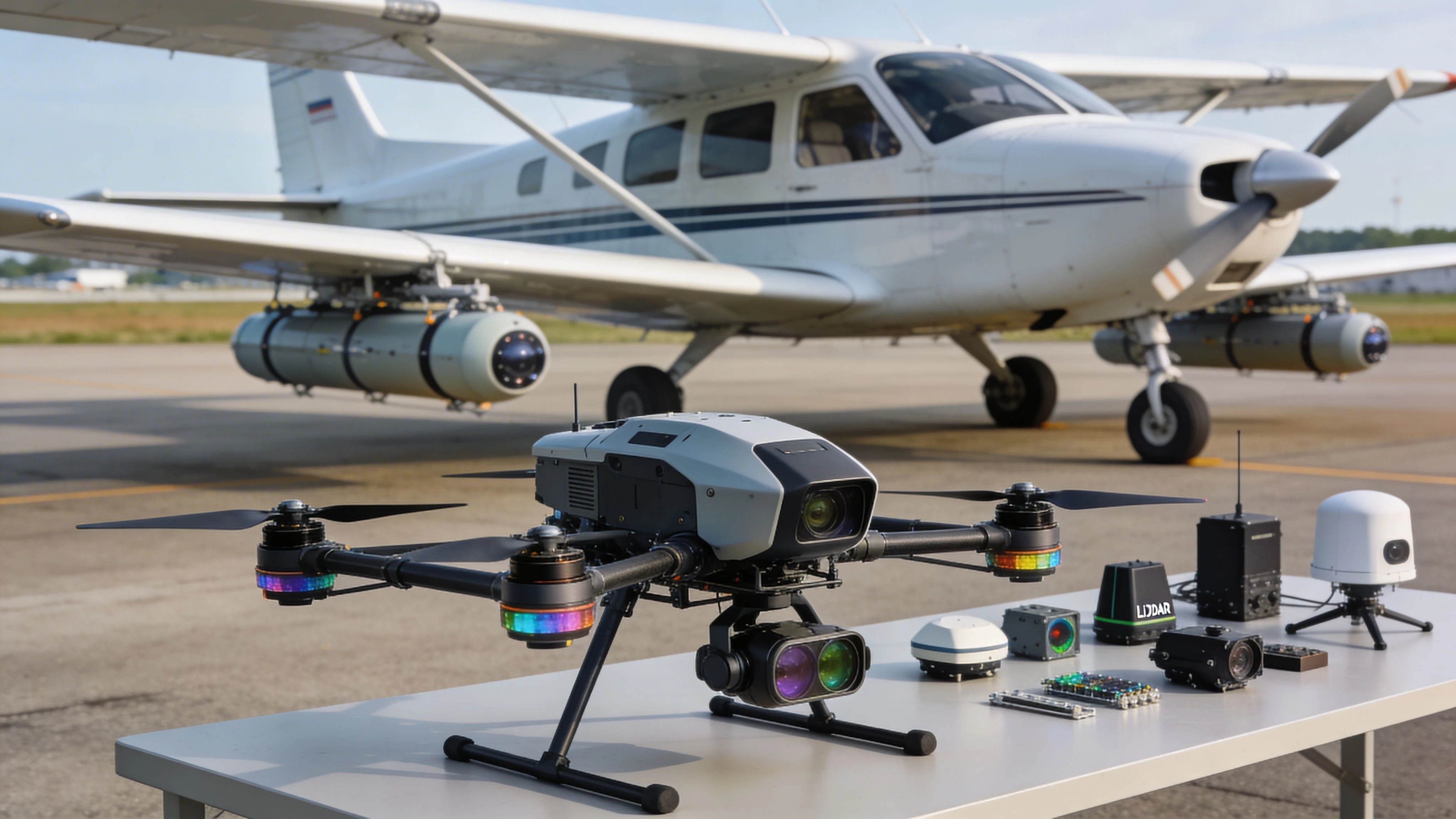
Choosing Your Tools Aircraft Drones and Sensors
The platform doesn’t make the pilot. But the wrong platform can ruin a job before takeoff.
Most aerial survey decisions come down to three questions. How large is the area. How precise does the client need the final output. And what conditions will the platform have to handle.
Manned aircraft versus drones
Neither side wins every time.
Manned aircraft still hold the advantage when the mission covers long corridors, broad regions, remote sites, or time-sensitive deployments. Drones are stronger when you need local flexibility, low-altitude detail, difficult access, or frequent repeat missions over smaller footprints.
Here’s the practical comparison.
| Tool | Where it fits | Where it struggles |
|---|---|---|
| Manned aircraft | Large-area mapping, long corridors, rapid regional coverage, some wildlife work | Smaller sites, tight urban launch constraints, lower-altitude detail jobs |
| Fixed-wing drone | Larger drone mapping areas, efficient coverage, consistent survey patterns | Tight launch/recovery spaces, some complex terrain profiles |
| Multi-rotor drone | Smaller sites, vertical assets, inspections, dense construction areas | Large-area productivity, long corridors, strong wind endurance in some cases |
For pilots moving between both worlds, it helps to study practical UAV mapping workflows rather than thinking only in aircraft categories. This overview of a mapping drone workflow is a useful reference: https://blog.dronedesk.io/uav-mapping-drone/
What the aircraft choice really affects
Platform selection changes more than endurance.
It affects your operating altitude, line count, payload size, weather tolerance, crew size, reposition options, and how painful the day becomes when conditions drift off plan. Airplanes cover ground efficiently. Drones can get closer, slower, and lower.
That’s why many serious operators now run mixed fleets. They use aircraft for breadth and drones for detail.
If the site is huge and the deadline is tight, the airplane often wins. If the site is awkward, obstructed, or needs very frequent revisits, the drone often wins.
Sensor choice drives the real value
Aerial survey clients often ask for “mapping,” but that word hides very different jobs.
RGB photogrammetry
This is standard visual mapping. You capture overlapping imagery and process it into orthomosaics, surface models, and 3D reconstructions.
It works well for construction progress, topographic surfaces, stockpiles, site planning, and visual documentation. It usually gives clients the most accessible output because everyone understands images.
LiDAR
LiDAR emits laser pulses and measures returns to build a point cloud.
It’s useful when surface geometry matters more than texture, or when vegetation complicates ground extraction. Forestry, terrain modeling, corridor work, and some infrastructure jobs benefit from it because it handles shape differently than passive imagery.
Thermal
Thermal sensors record heat variation, not visible detail.
That makes them useful for roof moisture patterns, solar inspection, utility diagnostics, wildlife detection in some settings, and search support. They’re powerful, but easy to misuse. Thermal data without disciplined timing and interpretation often creates more confusion than value.
Multispectral
Multispectral sensors capture light bands beyond normal RGB.
They’re commonly used in agriculture, habitat assessment, vegetation analysis, and environmental monitoring where plant condition matters more than appearance alone.
Choose based on deliverable, not gadget appeal
A lot of bad equipment buying starts with the pilot falling in love with the platform.
The better approach is reverse order:
- Start with the client outcome
- Choose the data type
- Select the sensor
- Match the platform to area, terrain, and logistics
That order keeps you from bringing a complicated sensor package to a job that only needed clean RGB mapping. It also keeps you from trying to stretch a multi-rotor over a site that really needs fixed-wing efficiency or a crewed aircraft.
What works in the field
The combinations that tend to hold up operationally are usually simple.
- Airplane plus large-format camera: Strong for broad coverage and corridor speed
- Fixed-wing drone plus RGB payload: Efficient for medium-to-large mapping blocks
- Multi-rotor plus RGB or thermal: Strong for local engineering, inspection, and repeat site visits
- Specialized platform plus LiDAR or multispectral: Worth it when the deliverable needs that data
What doesn’t work is mixing a platform and sensor because the brochure looked impressive. In this business, the cleanest setup that reliably delivers the right data usually beats the most complicated one.
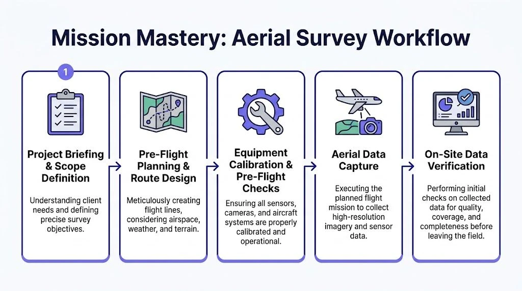
Mission Mastery From Pre-Flight Planning to Data Capture
Most survey failures don’t begin in the air. They begin on the ground with a bad plan.
Aerial survey work punishes loose preparation because small errors repeat across the whole mission. Wrong overlap, poor terrain planning, weak battery margin, inconsistent timing, and vague airspace checks all turn into expensive rework.
Start with the area, not the aircraft
The first job is to understand the site.
Look at terrain, land cover, obstacles, access, communications coverage, launch and recovery options, nearby airspace, and the shape of the target area. A rectangular site on flat ground is one thing. A long corridor crossing mixed terrain is another.
For large-area drone surveys, one practical method is to split complex terrain into segments and plan 20-30% overlap between those segmented flight areas. During capture, maintaining 80-90% sidelap/forward lap and using RTK GPS supports centimeter-level accuracy, according to this guidance on large-area aerial survey drone methodology.
Build a repeatable planning workflow
The cleanest operators don’t rebuild their process from scratch every job. They use the same planning sequence every time and adjust only where the mission demands it.
A practical workflow looks like this:
-
Confirm the deliverable
Orthomosaic, point cloud, thermal inspection set, wildlife count, corridor model. The deliverable defines everything downstream. -
Review terrain and access
This shapes altitude plan, launch locations, line orientation, and expected hazards. -
Check airspace and permissions
Don’t leave this as a last-minute app check on the tailgate. -
Assign platform and payload
Match the aircraft, sensor, batteries, mounts, and crews to the job. -
Set capture parameters
Height above ground, speed, overlap, camera settings, and timing. -
Prepare field documents and checklists
Good operators reduce memory load. They don’t rely on “we’ve done this before.”
For teams running multiple jobs, software matters here. Platforms such as Dronedesk are used to organize jobs, airspace checks, team readiness, asset records, and planning documentation in one workflow rather than scattering it across messages, spreadsheets, and disconnected apps.
Altitude, speed, and overlap aren’t guesses
These are mission controls. If you treat them casually, the dataset will show it.
Altitude
Your chosen altitude affects resolution, coverage per line, obstacle clearance, and terrain-following behavior. In mixed ground, a plan that looks fine on a flat basemap can fail badly in the field if the platform doesn’t maintain a consistent relationship to the surface.
Speed
Too fast and the sensor can’t support the image quality or observation task. Too slow and you lose efficiency, endurance margin, and sometimes stability.
Overlap
Overlap is where many newer operators cut corners. They think they can rescue weak coverage in processing. Sometimes they can’t.
The same large-area survey guidance notes that success rates can fall from over 85% in optimal conditions to 60-70% in mixed terrain because of power loss and signal instability. It also notes that lighting variation across multi-day flights can create 15-20% modeling errors, leading to re-flights in up to 25% of cases when temporal consistency breaks down in the dataset.
Bad overlap is expensive twice. You pay for it in the field, then you pay again in processing.
Field discipline matters more than gear hype
A modern survey mission still comes down to execution.
Before takeoff
Use a hard checklist. Confirm firmware and media status. Verify camera and mount settings. Confirm GNSS status, time sync, storage, battery health, and naming conventions.
If you run a crew, brief them in plain language. What are the lines. What are the abort points. What happens if signal degrades. Who owns the QC check before anyone leaves site.
During capture
Fly the plan unless a safety decision requires deviation. Monitor telemetry, battery trend, signal strength, winds, and actual line tracking.
In complex terrain, don’t get seduced by the mission display alone. Look outside, stay ahead of the aircraft, and keep a mental picture of terrain and escape options.
Between sorties
Review samples before launching the next block. Don’t assume everything is fine because the aircraft came back normally.
Check for blur, exposure issues, coverage gaps, time inconsistencies, and file anomalies while you can still fix them on site.
What usually causes trouble
The recurring failures are familiar.
- Lighting drift across days: The dataset stops matching cleanly
- Overconfident battery use: Margins disappear faster in demanding conditions
- Weak segmentation of large sites: The team tries to force one plan across terrain that needed several
- Poor on-site QC: Problems get discovered back at the office when re-flight is expensive
- Loose file handling: Data gets mixed, mislabeled, or partially overwritten
The pilots who look polished in this industry are usually the ones who reduced avoidable decisions before launch. They don’t act rushed. They act prepared.
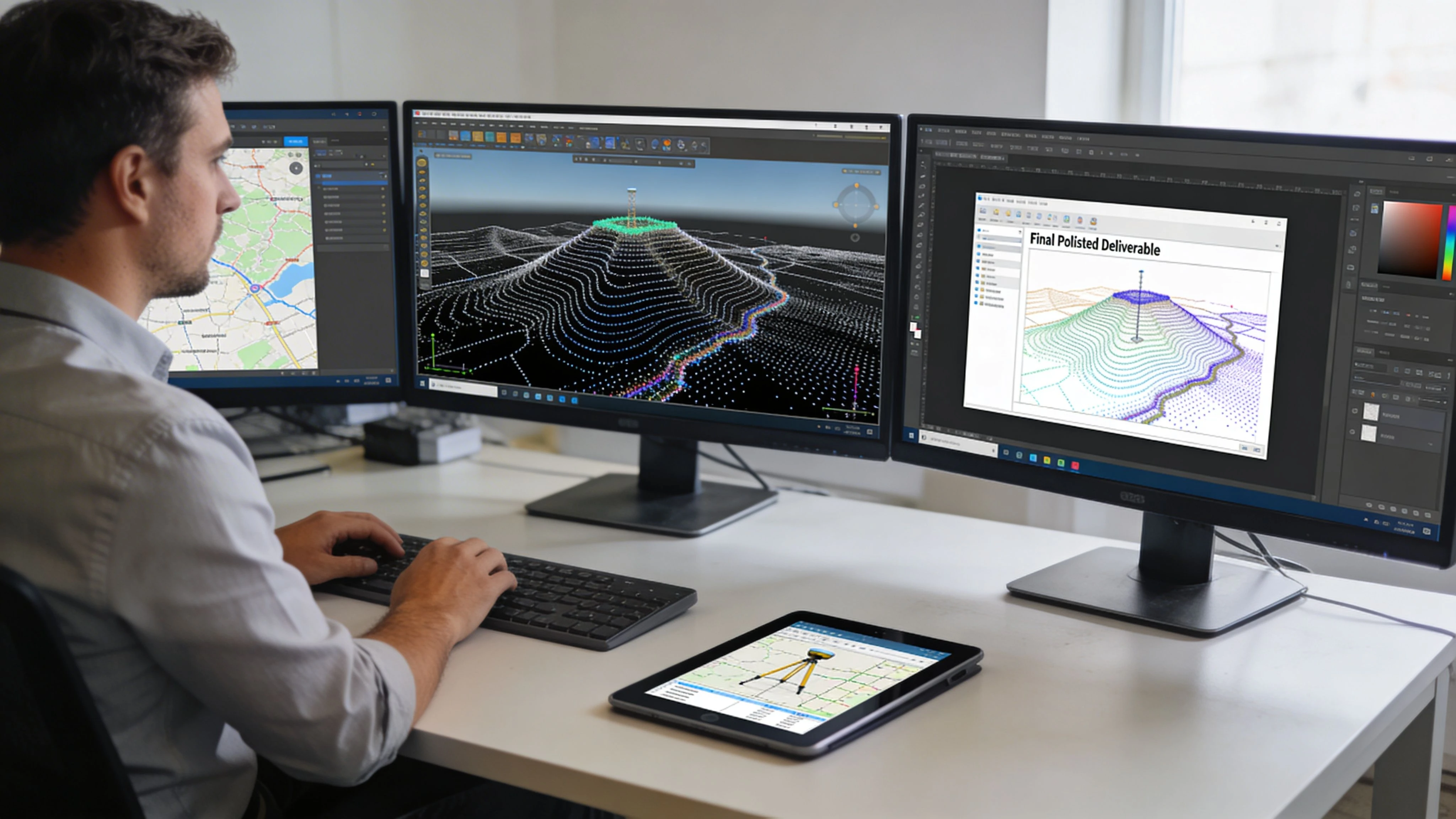
Turning Pixels into Profit Data Processing and Deliverables
A survey mission isn’t finished when the prop stops or the drone lands. It’s finished when the client receives data they can use without confusion.
That’s where many pilots hit a ceiling. They know how to collect data, but not how to turn it into a professional deliverable. The industry has moved beyond that split.
First, protect the raw data
Before you process anything, secure the files.
Copy the cards. Verify the copy. Keep the original structure intact. Label the job clearly. Separate field notes, GNSS data, imagery, logs, and any ground control records.
If a card fails or a drive starts throwing errors, don’t keep poking at it until you make the problem worse. In those cases, specialist data recovery services can be worth considering before critical project files are lost for good.
Quality control before heavy processing
Don’t burn hours building a model from weak input.
Run an early QC pass and confirm:
- Coverage completeness: No missing blocks or obvious gaps
- Image quality: Blur, motion issues, poor exposure, or focus drift
- Metadata integrity: Time, location, and file continuity make sense
- Ground consistency: Field notes match what was captured
A simple rule saves a lot of pain. If something looks off in preview, it usually looks worse after processing.
What the processing stage actually does
For photogrammetry, the workflow usually moves from aligned imagery to sparse geometry, then dense reconstruction, then usable outputs such as orthomosaics, elevation products, contours, and mesh models. In tools like Pix4D and Agisoft Metashape, the settings change, but the logic doesn’t.
LiDAR workflows differ, but the principle is the same. Clean the data, classify it properly, georeference it accurately, and export it in forms the client can work with.
If you’re building your own internal process, this guide on how to plan for data analysis is a useful complement to field operations: https://blog.dronedesk.io/plan-for-data-analysis/
Pilots now need data skills
This is no longer optional.
By early 2026, AI-powered workflows had accelerated cloud-based mapping processing by 40%, and the same trend is blurring the line between aviation and analytics. That shift raises practical retraining questions around sensor georeferencing and IMU precision. The same source also projects a 20-30% displacement risk for pilots by the end of the decade if they don’t retrain for data-centric roles, according to this piece on trends and challenges in the aerial mapping industry.
That doesn’t mean pilots are becoming obsolete. It means the valuable pilot is now the one who understands more of the chain.
The pilot who can explain georeferencing, coverage integrity, and processing limitations is harder to replace than the pilot who only says, “I flew the lines.”
Deliverables need interpretation, not just export
Clients don’t buy TIFFs because they love file formats.
They buy clarity. They want to know what the map shows, how reliable it is, where the edges are, and what they can use it for. That means your final package should include clean naming, clear coordinate information, and plain-language notes on any operational limits or site conditions that affected the result.
Good deliverables usually include
- The processed output in the format the client requested
- A short readme explaining projection, coverage, and known constraints
- Preview material so the client can inspect quickly
- Supporting notes on field conditions if they matter to interpretation
Weak deliverables usually look like this
- A folder dump with unclear names
- No explanation of what is final and what is intermediate
- No note about partial coverage, difficult lighting, or gaps
- No consistency between jobs from the same provider
The pilot who learns to think like a data producer, not only a collector, usually wins better repeat work.
Running a Successful Aerial Survey Business
Flying skill gets you hired. Business discipline keeps you in business.
Aerial survey operators often underprice, overcomplicate their gear, and talk too much about aircraft instead of outcomes. Clients usually care about reliability, clarity, and whether the data will stand up when someone questions it later.
Accuracy sells better than excitement
In wildlife work, credibility isn’t marketing fluff. It’s the contract.
Using a double-observer method, pilots can produce validated abundance estimates with precision (CV) of 6.1-25%, and that method achieved 100% validation on 6 tests. But the same research warns that non-uniform animal distribution can cause 10-20% undercounting. If you can explain those risks and how you mitigate them, you have a stronger commercial position than the operator who only promises “great coverage,” as shown in this research on aerial survey accuracy and bias correction.
That principle applies well beyond wildlife. Buyers trust operators who are honest about uncertainty.
Pick a niche before you try to scale
Generalist survey businesses can work, but most early operators do better when they become known for one thing first.
That niche might be:
- Construction progress and topo support
- Utilities and corridor imaging
- Mining and aggregates
- Wildlife and environmental monitoring
- Thermal inspection
- Local engineering and land development support
Niche focus sharpens everything. Your proposal language gets better. Your workflows tighten up. Your sample deliverables become more convincing.
Price the job around the outcome
Charging only by flight time is a trap.
The full cost includes planning, travel, permissions, field setup, capture, QC, processing, revisions, storage, and communication. The true value depends on what the client can decide because of your work.
A cleaner pricing model often separates:
| Pricing element | Why it matters |
|---|---|
| Mobilization | Travel, setup, site access, and scheduling have cost |
| Capture phase | Aircraft, crew time, batteries, field consumables, risk |
| Processing and QA | This is where a lot of labor actually sits |
| Deliverable package | Different outputs create different value |
| Revision scope | Protects you from endless “small changes” |
Client communication is part of risk management
A lot of bad projects start with unclear expectations.
Tell the client what you need before the mission. Confirm site boundaries, access, deliverable format, coordinate requirements, accuracy expectations, and any conditions that could delay or limit the work. After the mission, tell them what you captured, what passed QC, and what still needs processing.
Operators who communicate clearly usually look more expensive at quote stage and cheaper by the time the client compares outcomes.
Build systems before volume arrives
If you want to run more than a handful of jobs a month, you need operational structure.
That means having a workable system for:
- Lead tracking and quotations
- Scheduling crews and aircraft
- Maintenance and battery records
- Flight logs and job files
- Client approvals and reporting
- Invoice tracking and project review
Without that backbone, growth just creates more admin drag and more preventable mistakes.
The businesses that hold together long term tend to standardize early. They use templates, checklists, file structures, and planning workflows that don’t depend on one person remembering everything.
If you’re building or scaling a drone and survey operation, Dronedesk gives you one place to manage planning, compliance, teams, fleet records, client workflows, and reporting so the operation doesn’t fall apart in messages, spreadsheets, and disconnected apps.
 FAA Remote ID Rule Explained for Commercial Pilots →
 Drone Legal Requirements for Commercial Operations →
 Drone Near Airport Rules Explained for Safer Planning →
 International Drone Regulations Every Global Team Should Know →
 Drone Flight Risk Assessment Example for Safer Missions →
 Beyond Visual Line of Sight Explained for Operators →
 How BVLOS Drone Operations Change Commercial Workflows →
 FAA Drone Rules Every Commercial Pilot Should Know →
 FAA 107 Explained for Commercial Drone Operators →
 Canadian Drone Regulations Explained for Business Use →