Top Drone Mission Planning Software in 2025
Taking Off With the Right Drone Mission Planning Software
Drone technology has reshaped industries, from photography and videography to surveying, inspections, and even delivery services. But maximizing the potential of your drone depends on careful planning. Simply launching your drone and improvising is a recipe for poor results, wasted time, and potential safety hazards. Effective drone mission planning software addresses these challenges by providing a platform to design, simulate, and execute complex flight paths accurately. Whether you're mapping a large construction site, filming stunning aerial footage, or inspecting critical infrastructure, the right software is essential for mission success.
Selecting the best drone mission planning software hinges on several factors. Your specific needs, budget, and technical skills all play a role. Are you a single operator seeking a simple, intuitive interface? Or do you manage a team of drone pilots requiring collaboration tools and advanced data processing? Some software excels at automated flight planning for mapping, while others prioritize creating dynamic camera movements for captivating aerial cinematography. Pricing varies significantly, from free, open-source options to subscription-based platforms with enterprise-level features. Considering factors like supported drone models, operating system compatibility, and the available technical support is also vital.
Choosing the Right Software for Your Needs
An effective drone mission planning tool allows you to visualize your mission in 3D, create waypoints and define flight parameters, simulate flights to identify potential obstacles, and automate complex maneuvers. It can significantly reduce flight time, optimize battery life, and enhance data accuracy. Below, we explore seven leading drone mission planning software options for 2025, encompassing a range of features, functions, and price points to help you select the perfect tool for your aerial projects. From free and open-source solutions to powerful commercial platforms, you'll gain the knowledge you need to take your drone operations to the next level.
1. Dronedesk

Dronedesk stands out as a comprehensive drone operations management platform. It aims to simplify every facet of a drone business, from initial client interactions to post-flight reporting and ensuring regulatory compliance. This makes it a powerful tool for everyone, whether a solo drone operator or part of a large enterprise team.
Imagine juggling multiple clients, projects, and pilots as a drone service provider. Instead of relying on spreadsheets and emails, Dronedesk centralizes everything. Schedule flights, track fleet maintenance, manage pilot certifications, and generate detailed reports, all within a single, intuitive interface.
For surveyors, Dronedesk simplifies mission planning with advanced airspace intelligence, ensuring safe and compliant operations. Photographers and videographers can benefit from streamlined workflows, allowing them to focus on capturing breathtaking visuals.
Key Features and Benefits
-
Client Management: Organize client details, project requirements, and communication logs in one central location. This simplifies project management and boosts client satisfaction.
-
Fleet Management: Keep track of maintenance schedules, drone specifications, and flight logs for all aircraft. This proactive approach minimizes downtime and optimizes resource use.
-
Team Management: Manage pilot licenses, certifications, and availability. This streamlines scheduling and helps ensure regulatory compliance.
-
Flight Planning & Airspace Intelligence: Access real-time airspace information and plan flights with integrated mapping tools for safe and efficient operations.
-
Direct DJI Integration: Seamlessly synchronize flight logs and data from DJI drones, eliminating manual data entry and reducing administrative overhead. This is a major advantage for DJI users.
-
Detailed Reporting: Generate comprehensive reports for clients and internal stakeholders, showcasing compliance and demonstrating the value of your drone operations.
Pros and Cons
Pros:
- Comprehensive solution for managing clients, fleets, teams, and flight operations.
- Scalable pricing plans suitable for solo operators, small and medium-sized enterprises (SMEs), and large organizations.
- Direct DJI synchronization and advanced reporting for increased productivity and compliance.
- Highly rated with positive customer feedback and a proven record of time and cost savings.
- Streamlines complex processes into a single, user-friendly app.
Cons:
- Can have a steep learning curve for those transitioning from manual or spreadsheet-based systems.
- Some advanced features, like DJI synchronization, might be less beneficial for operators using non-DJI drones.
Pricing and Technical Requirements
Pricing: Dronedesk offers flexible plans tailored to various business sizes. Contact them directly for a personalized quote.
Technical Requirements: Dronedesk is a web-based platform, accessible from any device with an internet connection. The DJI synchronization feature requires compatible DJI drones.
Implementation Tips
-
Utilize Dronedesk's onboarding materials and tutorials to become familiar with the platform's functionalities.
-
Migrate existing data (client lists, drone information, etc.) into Dronedesk to establish a centralized overview.
-
Customize the platform's settings to align with your specific workflow and operational requirements.
Why Choose Dronedesk?
Dronedesk offers a truly comprehensive approach to managing every aspect of drone operations. Its intuitive interface, robust features, and scalability make it a valuable tool for drone professionals at all levels. While there may be an initial learning curve for those used to manual systems, the long-term gains in efficiency, compliance, and cost savings are considerable.
Website: Dronedesk
2. DJI Terra
DJI Terra is comprehensive drone mission planning software developed by DJI, allowing users to create automated flight missions for various applications. Its focus on mapping, 3D modeling, and inspection makes it a powerful tool for professionals in fields like surveying, construction, and infrastructure inspection.

DJI Terra shines with its real-time 3D model reconstruction capabilities, giving you a live view of the model as your drone flies. Coupled with AI-powered object recognition, this feature streamlines workflows for tasks like identifying structural defects or monitoring construction progress.
Multiple flight planning modes – Waypoint, Area, and Oblique – offer flexibility for different mapping and inspection scenarios. Advanced terrain following ensures consistent data acquisition even over complex landscapes. You might be interested in this guide on creating drone flight plans for a deeper dive into planning techniques.
Seamless integration with DJI drones is a significant advantage, simplifying setup and operation. Data processing is handled efficiently within the software, producing high-precision 2D orthomosaics and 3D models. DJI’s commitment to regular updates and strong technical support ensures a reliable and evolving platform.
While DJI Terra caters to a wide audience, from solo drone operators to enterprise teams, its tight integration with the DJI ecosystem means limited compatibility with non-DJI drones. The software also comes with a higher price tag than some alternatives. Processing large datasets requires relatively powerful hardware. Consider these factors when evaluating DJI Terra against your specific needs and budget.
Pros:
- Intuitive interface accessible to beginners
- Excellent integration with DJI hardware
- Powerful data processing capabilities
- Real-time 3D model reconstruction
- AI-powered object recognition
- Regular updates and strong technical support
Cons:
- Limited compatibility with non-DJI drones
- Higher price point compared to some alternatives
- Requires powerful hardware for large datasets
Website: https://www.dji.com/dji-terra
DJI Terra earns its place on this list because of its comprehensive feature set, powerful data processing, and seamless integration with the DJI drone ecosystem. While the price may be higher than some competitors, the robust functionality and reliable performance make it a worthwhile investment for professionals demanding high-quality results.
3. Pix4D

Pix4D is a leading drone mapping and photogrammetry software suite. It offers professional-grade tools for a variety of industries, making it a valuable asset for serious drone operations. From pre-flight planning to post-processing analysis and reporting, Pix4D provides a comprehensive solution. Whether you're in surveying, construction management, agriculture, or inspections, Pix4D has tailored solutions for specific workflows.
Practical Applications and Use Cases:
Surveying and Mapping
Create highly accurate orthomosaics, digital surface models (DSMs), and point clouds for land surveying, topographic mapping, and volumetric calculations. This data is particularly useful for monitoring construction progress, managing mine sites, and assessing environmental impact.
Agriculture
Pix4Dfields allows for crop health analysis, field scouting, and precise fertilizer application through multispectral and thermal imagery analysis. This empowers farmers to make data-driven decisions for optimized yield and resource management.
Construction and Infrastructure
Monitor construction sites, track progress, generate as-built models, and perform inspections of infrastructure like bridges and power lines. This ensures safety, helps manage resources effectively, and maintains accurate records.
Mining
Generate accurate maps of open-pit mines, monitor stockpiles, and analyze slope stability. This information aids in efficient resource extraction and improves site safety management.
Inspection
Conduct detailed inspections of buildings, cell towers, and other infrastructure using high-resolution imagery and 3D models. This enables efficient identification of defects and thorough damage assessment.
Key Features and Benefits:
- Specialized Industry-Specific Workflows: Pix4D offers solutions like Pix4Dfields for agriculture and Pix4Dsurvey for surveying, streamlining workflows for specific applications.
- Cloud and Desktop Processing: Choose cloud-based processing for speed and convenience or desktop processing for maximum control and offline work.
- RTK/PPK Support: Achieve centimeter-level accuracy with Real-Time Kinematic (RTK) and Post-Processed Kinematic (PPK) support.
- Advanced Analytics and Measurement Tools: Extract valuable insights from your data with integrated measurement tools, volume calculations, and in-depth analysis functionalities.
- Multi-Camera and Thermal Imaging Support: Process data from various camera types, including multispectral and thermal cameras, expanding the range of applications and data insights.
Pros:
- Extremely Accurate Photogrammetry Results: Pix4D is known for producing high-quality, precise 3D models and maps.
- Wide Range of Output Formats and Compatibility: Easily integrate with other software and platforms thanks to the diverse export options.
- Robust Ecosystem of Specialized Tools: Benefit from a suite of tools designed for specific industries, maximizing efficiency and effectiveness.
- Excellent Documentation and Training Resources: Comprehensive documentation and training materials are readily available to help master the software.
Cons:
- Steep Learning Curve for Beginners: The software's advanced features can be initially challenging for new users.
- Subscription-Based Pricing Can Be Expensive: The subscription model can be costly, especially for smaller businesses or infrequent users. Contact Pix4D for pricing details.
- Resource-Intensive for Large Projects: Processing large datasets can require significant computing resources.
Implementation/Setup Tips:
- Explore the tutorials and documentation on the Pix4D website.
- Begin with smaller projects to gain experience before tackling larger, more complex datasets.
- Ensure your computer meets the minimum system requirements for optimal performance.
Comparison with Similar Tools:
Pix4D stands out with its accuracy, comprehensive toolset, and specialized industry solutions. Alternatives like DroneDeploy and Agisoft Metashape offer similar functionality but may differ in industry-specific features and accuracy.
Website: https://www.pix4d.com/
4. DroneDeploy

DroneDeploy is a leading cloud-based drone mapping platform. It's ideal for a wide range of users, from individual drone operators to large enterprise teams. The platform offers a comprehensive set of tools, covering everything from mission planning and data processing to analysis and fleet management. Everything is accessible through a user-friendly interface.
This makes DroneDeploy a powerful choice across various industries. Some examples include agriculture, construction, mining, inspection, surveying, and even professional photography and videography. Its inclusion in this list is a no-brainer, thanks to its robust features, ease of use, and diverse applications.
Practical Applications and Use Cases
-
Construction: Track project progress, create 3D models of sites, calculate stockpile volumes, and perform accurate site surveys.
-
Agriculture: Generate NDVI maps for crop health assessments. Scout fields for areas of stress, and plan precise fertilizer or pesticide applications.
-
Mining: Survey mines and quarries, monitor extraction progress, calculate material volumes, and keep an eye on site safety.
-
Inspection: Inspect critical infrastructure such as cell towers, power lines, and bridges. Check for damage or defects and create detailed reports.
-
Surveying: DroneDeploy helps conduct topographic surveys. Create orthomosaics and digital surface models (DSMs) with impressive accuracy.
-
Photography/Videography: Plan complex flight paths for cinematic shots and capture breathtaking aerial imagery.
Key Features and Benefits
-
Live Map: This feature provides real-time mapping data as the drone flies. This allows users to quickly identify key areas and make immediate adjustments as needed.
-
Automated Flight Planning: Easily plan flights with automated terrain awareness. This ensures safe and efficient data acquisition.
-
Cloud Processing & Storage: Benefit from the power of the cloud. Enjoy virtually unlimited storage and powerful processing without needing a high-powered computer.
-
Fleet Management: Manage multiple drones, pilots, and projects efficiently. This streamlines operations, especially for larger teams.
-
Extensive App Marketplace: Customize DroneDeploy by integrating with a variety of third-party apps designed for specialized tasks.
Pros
-
Excellent Mobile App: The intuitive mobile app makes field operations a breeze. Plan, execute, and review initial data all from your mobile device.
-
Seamless Cloud Workflow: Streamlined cloud integration simplifies data transfer, processing, and sharing for quick turnaround times.
-
Wide Compatibility: DroneDeploy supports a wide range of popular drone models, giving you flexibility in hardware choices.
-
Powerful Collaboration Tools: Easily share projects and collaborate with stakeholders for efficient communication.
Cons
-
Internet Dependence: Requires a stable internet connection for optimal performance. This can be a challenge in remote locations.
-
Premium Features: Some advanced features require a higher-tier subscription, which can increase costs.
-
Limited Offline Capabilities: Offline functionality is not as comprehensive as some desktop-based software.
Pricing, Technical Requirements, and Setup Tips
DroneDeploy offers a variety of subscription plans to suit different needs and budgets. You can find pricing details on their website: DroneDeploy.
Technical Requirements: You'll need a compatible drone, a mobile device running iOS or Android, and a reliable internet connection.
Implementation/Setup Tips:
-
Plan Your Missions: Use the flight planning tools to carefully define waypoints, altitudes, and image overlap.
-
Explore the App Marketplace: Integrate relevant apps to customize your workflow for your specific industry.
-
Use Training Resources: DroneDeploy provides extensive tutorials and documentation to help you get the most out of the platform.
Comparison with Similar Tools
Several other drone mapping platforms are available, including Pix4D and Maps Made Easy. However, DroneDeploy’s user-friendly interface, robust cloud processing, and extensive app ecosystem make it a strong contender. Its focus on ease of use makes it a compelling choice for users of all skill levels.
5. UgCS

UgCS (Universal Ground Control Software) is a powerful drone control platform. Its adaptability makes it suitable for a wide range of operations, from basic mapping to complex industrial inspections. UgCS offers the tools and flexibility needed for demanding projects. It's particularly well-suited for users who value advanced flight control, support for multiple drones, and the ability to operate offline. This makes it a valuable tool for everyone from individual drone operators to larger enterprise teams.
UgCS supports over 60 drone models from various manufacturers. This eliminates the need to switch between different software platforms, making it a convenient solution for organizations with a diverse drone fleet. Its advanced 3D mission planning tools include terrain following and photogrammetry features for precise data acquisition. For intricate inspections, like power line surveys or cell tower assessments, the ability to pre-plan complex flight paths in 3D space is essential. Additional features like joystick and gamepad support allow for enhanced manual control when needed. Offline maps and a no-fly zones database ensure uninterrupted operation, even in remote areas with limited internet access.
For professionals working in challenging locations or on time-sensitive projects, UgCS's offline capabilities are a major advantage. Planning and executing missions without needing a constant internet connection adds reliability and efficiency. For a broader look at drone flight planning software, check out our guide on drone flight planning software.
Considering the Costs and Benefits
While UgCS is feature-rich, it does have a steeper learning curve. The complex interface can initially feel overwhelming for new users. However, taking the time to master the software provides a high level of control and flexibility. While a one-time purchase option is available, the initial cost for professional licenses might be a barrier for some. Compared to simpler, subscription-based software, UgCS requires a larger upfront investment.
Key Features
- Support for 60+ drone models
- Advanced 3D mission planning with terrain following
- Photogrammetry toolset
- Joystick/gamepad support
- Offline maps and no-fly zones database
Pros
- Exceptional multi-platform drone support
- Powerful route planning for complex missions
- Excellent offline capabilities
- One-time purchase option available
Cons
- Steeper learning curve
- Higher initial cost
- Less streamlined for beginners
Website: https://www.ugcs.com/
Implementation Tip
Take the time to explore the tutorials and documentation provided by UgCS. While the interface is complex, the available resources can significantly shorten the learning process. Start with simple missions to get comfortable with the core features before moving on to more complex projects.
6. Litchi

Litchi is powerful, yet affordable mission planning software designed for DJI drones. This makes it a great option for hobbyists, small businesses, and even some enterprise users. It bridges the gap between basic flight apps and the often complex, pricey enterprise-level solutions. Litchi offers a solid set of features at a fraction of the cost. Its user-friendly platform for creating autonomous missions, from simple waypoints to complex 360° panoramas, earns it a spot on this list.
Litchi's intuitive, web-based mission hub is a key strength. Users can plan flights on a desktop, leveraging a larger screen for easier manipulation of waypoints, orbits, and other critical flight parameters. This pre-flight planning is essential for complex missions requiring precise positioning and timing. Once uploaded to the mobile app, operators can monitor the flight and adjust as needed.
Litchi's versatile feature set caters to a wide range of needs. Waypoint missions let users define specific GPS coordinates, altitudes, speeds, and actions (like capturing photos or videos) at each waypoint. This is particularly useful for aerial photography, videography, and inspections. Orbit mode allows the drone to automatically circle a point of interest, capturing dynamic footage from every angle, ideal for showcasing landscapes or structures.
Advanced Flight Modes and Features
Follow Me and Track modes provide intelligent subject tracking, perfect for action sports or any moving subject. Litchi also simplifies 360° panorama capture, automating the process for immersive imagery. For a truly engaging experience, the software includes a Virtual Reality mode, providing a first-person view.
Features:
- Web-based mission hub for desktop planning
- Waypoint missions with detailed control over altitude, speed, and actions
- Orbit, Follow Me, and Track modes for dynamic shots
- 360° panorama capture automation
- Virtual Reality mode
Pros:
- Affordable compared to enterprise solutions (one-time purchase, typically under $30)
- User-friendly interface and easy to learn
- Active community support and online resources
Cons:
- Compatible only with DJI drones
- Fewer advanced mapping and data processing features than enterprise software
- Limited direct technical support
Implementation Tips:
- Plan and simulate in the web-based mission hub before flying.
- Explore online tutorials and community forums.
- Start with simple missions before tackling complex flight plans.
Comparison: While Litchi offers powerful features, it doesn't provide the same level of mapping, data processing, and collaboration as solutions like DroneDeploy or Pix4D. These enterprise platforms are usually subscription-based and designed for larger projects. Litchi, however, is a budget-friendly and accessible alternative for individuals and smaller teams.
Website: https://flylitchi.com/
Litchi offers a compelling blend of advanced features and affordability. It's a valuable tool for a variety of drone operators, offering user-friendly autonomous flight capabilities for stunning aerial footage and streamlined data collection.
7. QGroundControl

QGroundControl stands out as a leading free and open-source software for drone mission planning. Its comprehensive features and compatibility with MAVLink-enabled drones, especially those using PX4 and ArduPilot, make it a compelling option for both hobbyists and professionals. It's especially popular among those involved in research, development, and custom drone building.
While commercial software might offer more polished user interfaces and automated functions, QGroundControl's flexibility and affordability are hard to beat. It offers complete flight control, allowing manual piloting, along with sophisticated mission planning capabilities.
You can design intricate flight paths using waypoints, automate camera triggers for mapping and surveys, and fine-tune parameters for specific actions. This precise control is invaluable for aerial photography, videography, infrastructure inspection, and agricultural monitoring. Joystick and gamepad integration further enhance the control experience.
Setting Up Your Drone with QGroundControl
The Vehicle Setup feature streamlines the configuration of your drone's airframe, radio, sensors, and firmware. This simplifies the often-complex process of getting your drone ready for flight. QGroundControl’s cross-platform compatibility is a significant advantage.
It works seamlessly on Windows, macOS, Linux, iOS, and Android, ensuring a consistent experience across devices. This is particularly helpful for teams working with a variety of hardware. You might find this helpful: Our guide on Drone Management Software.
Key Features of QGroundControl
- Support for PX4 and ArduPilot powered vehicles
- Comprehensive flight control and parameter configuration
- Survey planning with camera triggering for mapping
- Joystick and gamepad integration
- Vehicle Setup for airframe, radio, sensors, and firmware
Pros and Cons of QGroundControl
Here's a quick overview of the advantages and disadvantages:
| Pros | Cons |
|---|---|
| Free and Open-Source: No licensing fees | Steeper Learning Curve: Can be challenging for beginners |
| Excellent Compatibility | Less Polished UI: Not as refined as paid options |
| Cross-Platform Support | Limited Customer Support: Primarily community-based |
| Deep Parameter Access | Fewer Automated Analysis Features |
Website: http://qgroundcontrol.com/
Implementation Tip
New to QGroundControl? Start by exploring the online documentation and tutorials. The active community forum is an excellent resource for troubleshooting and getting advice from experienced users. Begin with a simple mission plan and gradually explore the more advanced features as you become more comfortable.
Side-by-Side Drone Mission Planning Software Comparison
| Platform | Core Features ✨ | User Experience ★ | Value Proposition 💰 | Target Audience 👥 |
|---|---|---|---|---|
| 🏆 Dronedesk | All-in-one ops, client/fleet/team mgmt, DJI sync & reporting | Intuitive interface, 5.0 rating | Scalable pricing; cuts planning time by 50% | Solo pilots to multinational corporations |
| DJI Terra | Automated missions, 3D modeling, mapping & DJI integration | Beginner friendly, efficient | High precision; premium pricing | Surveyors, construction, inspection crews |
| Pix4D | Photogrammetry, mapping, industry-specific workflows | Accurate results, robust analytics | Subscription-based; high ROI for complex projects | Surveying, agriculture, mining, construction |
| DroneDeploy | Cloud-mapping, automated flight planning, fleet management & storage | User-friendly, mobile optimized | Flexible subscriptions; powerful cloud processing | Agriculture, construction, SMEs |
| UgCS | Advanced 3D planning, multi-drone support, offline maps | Feature-rich, flexible, offline capable | One-time purchase option; ideal for complex missions | Enterprise teams & professional mission planners |
| Litchi | Waypoint missions, orbit, tracking, 360° panoramas | Affordable, easy to learn | One-time purchase; cost-effective for advanced features | Hobbyists and small businesses |
| QGroundControl | Open-source flight control, full mission planning, DIY customization | Powerful yet less polished for newcomers | Free and open-source; extensive parameter control | Researchers, DIY enthusiasts, custom drone builders |
Choosing Your Flight Path
Selecting the right drone mission planning software is paramount for safe and efficient operations. With numerous options available, from streamlined mobile apps like Litchi to robust platforms like DJI Terra and Pix4D, choosing the best fit requires careful consideration. Factors like budget, desired features, drone compatibility, and your team's technical skills all play a crucial role.
When comparing tools, consider your specific tasks. Are you focused on photogrammetry (Pix4D, DroneDeploy)? Or perhaps autonomous waypoint missions (UgCS, DJI Terra) are your priority. Do you need a more integrated solution to manage your entire drone operation, including client and team management (Dronedesk)? Some software excels in niche areas, while others offer a broader range of functionalities.
Implementation can range from simple mobile app installations to complex software deployments. Consider each tool’s learning curve. Some offer intuitive interfaces and tutorials, while others might require more in-depth training.
Budget is a critical factor. Free, open-source options like QGroundControl offer excellent functionality but may lack the advanced features and support of paid software. Paid options range from affordable monthly subscriptions for individuals to enterprise-level packages with custom pricing. Factor in the potential return on investment offered by increased efficiency, improved data acquisition, and streamlined workflows.
Integration and compatibility are also key. Ensure the software supports your drone models and integrates with your existing hardware and software. Consider whether you need data syncing with cloud services, GIS platforms, or other industry-specific tools.
Key Takeaways
-
Define Your Needs: Identify the core functionalities your operations require.
-
Evaluate Features: Compare each software's features against your requirements.
-
Consider Your Budget: Explore pricing plans and assess the return on investment.
-
Assess Ease of Use: Choose a platform that aligns with your team’s technical expertise.
-
Check Compatibility: Verify compatibility with your drone models and existing systems.
Dronedesk offers a comprehensive drone operations management platform designed for professionals. From client and fleet management to advanced airspace intelligence and detailed reporting, Dronedesk provides an end-to-end solution that enhances safety, increases productivity, and ensures compliance. Simplify your flight planning, manage your team effectively, and gain valuable operational insights. Take control of your drone operations and elevate your business with Dronedesk. Learn more and explore our plans at Dronedesk
 BVLOS Drone Meaning and Why It Matters →
 Drone Operation Regulations Explained for Businesses →
 How to Pass Your Drone Pilot License Test →
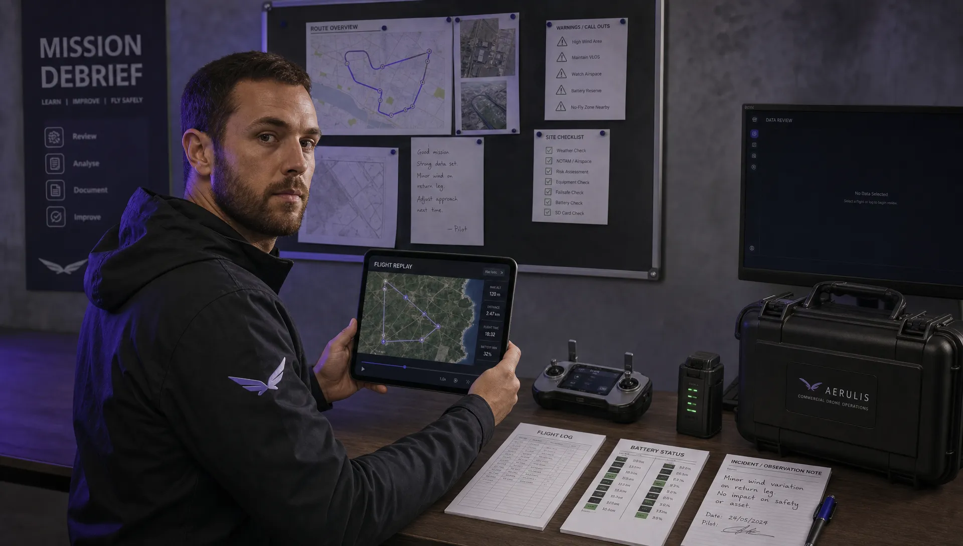 How to Review a DJI Flight Record After a Mission →
 How to Check a Drone NOTAM Before You Fly →
 Part 108: What Drone Operators Should Expect →
 Beyond Visual Line of Sight BVLOS Explained →
 Drone Laws and Regulations Every Team Should Review →
 Current Drone Laws: What Changed in 2026? →
 JARUS SORA Explained in Plain English →