Drone Flight Planning Software - Top Picks 2025
Taking Off with the Right Plan: Choosing Your Ideal Drone Flight Planning Software
Safe, efficient, and productive drone operations require careful planning. This listicle presents seven leading drone flight planning software solutions to streamline your workflows and maximize your results. Whether you're a solo operator, part of a small team, or managing enterprise-level drone operations, this list will help you find the right tool. Discover the key features of Dronedesk, DroneDeploy, Pix4D, UgCS, DJI GS Pro, Litchi, and Maps Made Easy and choose the best drone flight planning software to meet your specific needs. These tools help solve complex flight path creation, automated data acquisition, and regulatory compliance issues.
1. Dronedesk
Dronedesk stands out as a comprehensive drone flight planning software solution designed to streamline every facet of your drone operations. Trusted by thousands of professional pilots worldwide, it consolidates client and team management, flight planning, real-time airspace monitoring, and robust reporting into a single, sleek interface. This end-to-end platform is recognized for its ability to cut job planning time by at least 50%, making it ideal for everything from solo drone operators to large enterprise fleets.

Among its robust features, Dronedesk offers advanced flight planning tools complete with airspace and proximity intelligence, direct data syncing with DJI drones, and auto-generated financial and maintenance reports. This positions it as a true all-in-one solution compared to other tools that often require a patchwork of different systems or outdated spreadsheet-based methods. Additionally, its scalable pricing plans and money-back guarantee underline Dronedesk’s commitment to efficiency and user satisfaction. While the advanced integration with DJI drones offers significant benefits, users operating other brands may find that additional setup is necessary.
Key benefits of using Dronedesk include:
• A highly intuitive, integrated platform for managing complex drone operations
• Real-time airspace data and sophisticated flight planning capabilities
• Comprehensive reporting that handles everything from maintenance logs to financial summaries
• A perfect 5-star rating from over 350 pilots, reinforcing its popularity and ease of use
• A significant reduction in planning time, saving at least 50% of the effort compared to traditional methods
Some potential cons include:
• The breadth of features may be more than what very casual or infrequent users require
• Optimal integration is primarily geared towards DJI drones, potentially requiring extra steps for users of other drone models
For more detailed insights on integrating Dronedesk into your operation and making the most out of its advanced features, Learn more about Dronedesk. To explore pricing options, technical requirements, and hands-on tips for implementation, visit the official Dronedesk website. Whether you're a professional photographer, a surveyor, or an enterprise drone operations manager, Dronedesk offers a smarter, simpler solution for safer and more efficient drone mission planning.
2. DroneDeploy
DroneDeploy is a leading cloud-based drone flight planning software solution that simplifies complex aerial data collection and analysis for various industries. From automated flight planning and real-time mapping to sophisticated 3D modeling and AI-powered analytics, DroneDeploy provides a comprehensive toolkit for professionals and beginners alike. This makes it a strong contender for anyone looking for powerful drone flight planning software and earns its place on this list due to its versatile features and user-friendly interface. Whether you're a solo drone operator mapping a small construction site or an enterprise managing a large-scale agricultural project, DroneDeploy offers the tools to plan, execute, and analyze your drone missions effectively.

One of DroneDeploy's core strengths lies in its automated flight planning capabilities. Users can easily design flight paths by selecting the area of interest and specifying parameters such as overlap, altitude, and flight speed. This automation significantly reduces flight planning time and ensures consistent data acquisition. The platform's real-time mapping feature allows users to visualize the drone's progress and collected data during the flight, providing immediate feedback and enabling on-the-fly adjustments. This is particularly valuable for time-sensitive operations like search and rescue or disaster response. After the flight, data is automatically uploaded to the cloud for processing, generating high-resolution maps, 3D models, and analytical reports.
DroneDeploy caters to a broad range of industries, offering specialized tools and workflows for specific applications. For example, in agriculture, it provides tools for crop health analysis, identifying areas needing irrigation or fertilization. In construction, it facilitates site surveys, progress tracking, and volume calculations. For surveyors and utility inspectors, DroneDeploy allows for precise measurements and asset inspections.
Features & Benefits:
- Automated Flight Planning: Customize flight parameters like altitude, overlap, and flight speed for optimal data acquisition.
- Real-Time Mapping & Live Streaming: Visualize data as it’s collected, allowing for real-time decision-making.
- Cloud-Based Processing: Automatically upload and process data into orthomosaics, 3D models, and analytical reports.
- Cross-Platform Compatibility: Access and manage projects from iOS, Android, and web browsers.
- AI-Powered Analytics: Leverage industry-specific tools for tasks like crop health analysis, volume calculations, and asset inspection.
Pros:
- User-friendly interface accessible to both beginners and experienced professionals.
- Wide compatibility with numerous drone models, including DJI drones.
- Powerful analytics and reporting features for actionable insights.
- Robust mobile app for convenient field operations.
Cons:
- Access to premium features requires a subscription, which can be expensive for some users.
- Processing large datasets can be time-consuming.
- Reliable internet connection is essential for most functionalities.
- Advanced analytics features may require a learning curve.
Pricing: DroneDeploy offers various subscription plans tailored to different needs and budgets. Details on specific pricing tiers can be found on their website.
Technical Requirements: A compatible drone, a mobile device (iOS or Android) or computer with internet access, and a DroneDeploy account are required.
Implementation Tips: Familiarize yourself with the basic flight planning tools before tackling more advanced features. Utilize the available tutorials and resources on the DroneDeploy website to maximize the platform’s potential. Experiment with different flight parameters to optimize data acquisition for your specific needs.
Comparison: While other drone flight planning software solutions like Pix4D and Litchi offer similar functionalities, DroneDeploy stands out with its comprehensive cloud-based platform, user-friendly interface, and industry-specific analytical tools.
Website: https://www.dronedeploy.com/
3. Pix4D
Pix4D stands out as a leading professional drone flight planning software solution for users demanding high accuracy and comprehensive data processing. It offers an end-to-end workflow, from meticulously planning your drone's flight path to transforming the captured imagery into actionable 2D maps, 3D models, and precise measurements. This makes it a powerful tool for a range of professionals, from surveyors and construction managers to agricultural specialists and infrastructure inspectors. Pix4D's commitment to precision and its robust feature set justify its inclusion in this list of top drone flight planning software options. Whether you're mapping a large construction site, surveying agricultural land, or inspecting critical infrastructure, Pix4D provides the tools to generate highly accurate and detailed data products.

One of Pix4D's strengths is its advanced flight planning capabilities, incorporating terrain awareness for optimized data acquisition. This feature is crucial for accurately mapping uneven terrain, ensuring the drone captures images at the correct altitude and angles. The software also boasts precise photogrammetry processing, transforming overlapping images into georeferenced 2D and 3D outputs. Pix4D offers several specialized industry solutions, such as Pix4Dfields for agriculture and Pix4Dmapper for general mapping and modeling, catering to specific workflow needs. The platform supports various output formats, including point clouds, orthomosaics, and 3D models, giving users flexibility in their data analysis. For enhanced accuracy, Pix4D integrates seamlessly with ground control points (GCPs). Learn more about Pix4D to see how its features can be implemented for various projects.
Pix4D offers both desktop and mobile solutions, catering to different user preferences and fieldwork demands. While Pix4D is renowned for its accuracy and powerful features, it's worth noting that the software comes at a higher price point compared to other drone flight planning software options. Its robust processing algorithms may also require more powerful computer hardware. Furthermore, the software has a steeper learning curve than some simpler alternatives, and certain specialized modules might require separate licenses.
Pros:
- Extremely high accuracy in measurements and outputs
- Comprehensive desktop and mobile solutions
- Robust processing algorithms for complex environments
- Strong technical support and training resources
Cons:
- Higher price point compared to competitors
- Steeper learning curve for new users
- Resource-intensive processing requirements
- Some modules require separate licenses
Website: https://www.pix4d.com/
Pix4D's pricing varies depending on the specific product and license type. They offer different subscription options for individuals and enterprises, with flexible durations and feature sets. It is advisable to contact Pix4D directly or visit their website for detailed pricing information based on your specific requirements. Regarding technical requirements, Pix4D recommends a powerful computer with a dedicated graphics card, ample RAM, and sufficient storage space for processing large datasets. Specific system requirements are available on the Pix4D website. For new users, taking advantage of Pix4D's training resources and tutorials is highly recommended to fully leverage the software's capabilities and optimize workflows.
4. UgCS
UgCS (Universal Ground Control Software) stands out as a professional-grade drone flight planning software, empowering users to orchestrate complex drone missions with remarkable precision. Unlike more basic flight planning apps, UgCS caters to demanding scenarios encountered in professional applications such as surveying, infrastructure inspection, search and rescue operations, and advanced research projects. Its compatibility with a diverse range of drone models and autopilot systems makes it a versatile choice for serious drone operators. This robust software provides a comprehensive suite of tools that goes beyond simple waypoint navigation, offering advanced features like terrain following and multi-drone control, securing its place on this list of top drone flight planning software options.

A key strength of UgCS lies in its support for various drone autopilot systems, including popular platforms like DJI, ArduPilot, and PX4. This cross-compatibility allows drone teams to standardize their flight planning software across their fleet, regardless of the specific drone models in use. For instance, a team conducting both aerial photography with a DJI drone and LiDAR surveys with a custom-built ArduPilot platform can leverage UgCS for both operations. This simplifies workflows, streamlines training, and ultimately enhances operational efficiency. Furthermore, its terrain-following flight modes, coupled with elevation data integration, enable automated flight path adjustments to maintain a consistent altitude above varying terrain—crucial for capturing high-quality data in surveying and inspection tasks. Imagine inspecting a pipeline that traverses rolling hills: UgCS allows the drone to autonomously adjust its altitude, ensuring consistent camera angles and data resolution throughout the flight.
UgCS truly shines in its advanced mission planning capabilities. It allows operators to plan complex missions with multiple drones, facilitating coordinated operations for large-scale projects or time-sensitive scenarios. Integrated photogrammetry tools provide automated camera control, optimizing image acquisition for 3D model generation. Furthermore, the software incorporates no-fly zone information and obstacle avoidance features to enhance safety and regulatory compliance.
While UgCS offers unparalleled control and flexibility, it's worth noting that the interface is more complex than some competitor drone flight planning software, requiring dedicated training to fully master. The cost for professional licenses is also higher, reflecting the software's advanced capabilities and target audience. Certain advanced features, such as specific sensor integrations or specialized mission types, may require additional modules at extra cost. While the workflow is highly customizable, it may feel less streamlined compared to more basic drone flight planning software options.
Pros:
- Comprehensive control options for complex missions
- Works with multiple drone platforms and manufacturers
- Offline operation capabilities
- Highly customizable flight parameters
Cons:
- Complex interface requiring significant training
- Higher cost for professional licenses
- Some advanced features require additional modules
- Less streamlined workflow than some competitors
Website: https://www.ugcs.com/
UgCS excels in demanding operational environments, providing the tools professionals need for complex drone flight planning. While the learning curve and cost may be higher than simpler drone flight planning software, the benefits in terms of control, flexibility, and multi-platform support make UgCS a powerful solution for serious drone operations. Implementation typically involves installing the software on a Windows, macOS, or Linux computer, connecting the desired drone, and configuring the mission parameters within the UgCS interface. Users should consult the UgCS documentation and tutorials for detailed setup instructions and best practices.
5. DJI GS Pro (Ground Station Pro)
DJI GS Pro is a dedicated drone flight planning software designed specifically for DJI drones. This powerful app caters to a wide range of applications—from mapping and agriculture to inspections—making it an excellent choice for solo drone operators, small to medium teams, and enterprise managers. DJI GS Pro stands out due to its suite of professional, yet user-friendly, planning tools embedded within the DJI ecosystem.

The practical applications of this drone flight planning software are extensive. With its intuitive mission planning interface, users can quickly set up automated flight paths using grid, linear, and polygon patterns. This capability is ideal for creating detailed 3D maps in complex environments, a crucial feature for surveyors and utility inspectors. The inclusion of virtual fence features ensures that flight missions are safe and within the designated boundaries, essential for both agricultural tasks and infrastructure inspections. Additionally, team collaboration features allow multiple operators to coordinate on missions which is particularly beneficial for enterprise drone operations.
Key Features:
- Intuitive mission planning interface with virtual fence capabilities for safe operation.
- Automated grid, linear, and polygon flight path creation to streamline complex missions.
- Advanced 3D mapping mission planning to capture detailed terrain data.
- Team collaboration tools, ideal for coordinating drone flights in multi-operator environments.
- Compatibility with most professional DJI drone models, providing seamless integration with DJI hardware.
Pros:
- Seamless integration with DJI drones creates a plug-and-play experience.
- One-time purchase model means no recurring subscription fees.
- Reliable performance with DJI hardware enhances mission reliability.
- Straightforward interface simplifies the process of planning basic and complex missions.
Cons:
- iOS only (iPad), which excludes Android users from accessing the tool.
- The software is limited to the DJI ecosystem, reducing its utility for operators with mixed-brand fleets.
- Fewer advanced analytics features compared to some competitors.
- Less frequent updates, as DJI Pilot has become the primary focus for updates and improvements.
Pricing and Technical Requirements: DJI GS Pro operates on a one-time purchase basis, eliminating ongoing subscription costs—a significant draw for many professional users. However, note that it is available only on iOS (iPad), which means you’ll need an appropriate Apple device to run the app effectively. This focus ensures optimization for DJI hardware but does limit device compatibility.
Implementation Tips:
- Before setting up a mission, verify that your iPad and DJI drone firmware are both up-to-date to maximize compatibility.
- Start by exploring the intuitive mission planning interface using pre-set templates available within the app, and gradually tailor your missions to your specific operational needs.
- Leverage the virtual fence and automated flight path features to ensure safe and efficient coverage of your target area.
- Consider utilizing the team collaboration features if coordinating with a drone team, enabling real-time planning adjustments and oversight.
For anyone seeking advanced drone flight planning software, especially operators who are deeply embedded in the DJI ecosystem, DJI GS Pro offers a robust, cost-effective solution. Its combination of practical features and professional capabilities make it a top contender among drone flight planning software options. Learn more at the DJI GS Pro website.
6. Litchi
Litchi is a powerful and versatile drone flight planning software option that caters particularly well to consumers and prosumers using DJI drones. It bridges the gap between basic flight apps and complex professional solutions, offering a suite of automated flight features at an accessible price point. This makes it an excellent choice for anyone looking to elevate their drone operations, from capturing stunning cinematic footage to performing semi-autonomous flights, without breaking the bank. Whether you're a solo drone operator, part of a small team, or even a professional photographer experimenting with aerial perspectives, Litchi offers compelling features for a variety of drone flight planning needs.

One of Litchi's core strengths lies in its intuitive waypoint mission planning capabilities. You can easily plot flight paths with precise altitude control, allowing for complex maneuvers and intricate aerial surveys. This is particularly useful for tasks like utility inspections, where drones need to follow specific routes and maintain consistent altitudes. Beyond waypoint missions, Litchi's focus and tracking modes unlock a world of creative potential for videographers. These intelligent flight modes enable dynamic, cinematic shots by automatically keeping the camera locked onto a moving subject, allowing you to focus on framing and composition. For example, you could effortlessly film a moving vehicle from a variety of angles, creating professional-looking tracking shots without needing a dedicated camera operator.
Litchi's Mission Hub, a web-based planning interface, further streamlines the workflow. You can plan missions comfortably on a larger screen and seamlessly sync them to your mobile device for execution. This is particularly beneficial for complex missions requiring detailed planning and coordination. The inclusion of a Virtual Reality mode also adds an exciting dimension, allowing for immersive FPV-style flying, adding an element of fun to exploration and aerial photography. Moreover, features like orbit mode, panorama capture, and other intelligent flight modes provide versatile tools for various applications, from showcasing points of interest to creating stunning panoramic images.
Litchi is available as a one-time purchase for both iOS and Android devices, making it significantly more affordable than subscription-based professional drone flight planning software. While pricing may vary slightly depending on the platform, it generally remains very competitive. This one-time purchase model is a significant advantage, especially for budget-conscious users.
However, it's important to be aware of Litchi's limitations. It lacks some of the advanced mapping-specific features found in professional solutions, making it less suitable for large-scale commercial mapping projects. Furthermore, while it works with many consumer DJI drones, compatibility with specific features can vary depending on the drone model. It's crucial to check the compatibility list before purchasing. Finally, because Litchi is a third-party application, it doesn’t have direct technical support from DJI.
Despite these limitations, Litchi earns its place on this list as a powerful, affordable, and versatile drone flight planning software. Its intuitive interface, comprehensive features, and cross-platform availability make it an excellent option for a wide range of users, from hobbyists seeking to expand their creative horizons to professionals needing a cost-effective solution for specific flight planning tasks. You can explore Litchi’s full feature set and compatibility information on their website: https://flylitchi.com/
7. Maps Made Easy
Maps Made Easy earns its spot on this list of top drone flight planning software options by offering a compelling blend of flight planning and map processing capabilities, all within a user-friendly web-based platform. This makes it a valuable tool for a variety of users, from solo drone operators capturing stunning aerial photography to enterprise teams conducting large-scale surveys. It distinguishes itself from other drone flight planning software by integrating powerful map processing tools directly into the platform. This streamlined workflow allows you to plan your flight, capture your imagery, and process it into orthomosaics, 3D models, and volumetric measurements all in one place. For those focused on generating accurate measurements and maps from their drone data, Maps Made Easy is particularly well-suited.

A key advantage of Maps Made Easy is its flexible pay-per-use processing model, complemented by subscription options for frequent users. This allows solo operators and small teams to only pay for what they need, avoiding the high upfront costs associated with some desktop software. While dedicated drone flight planning software may offer more advanced features like terrain following and obstacle avoidance, Maps Made Easy provides a good balance of usability and professional features, making it an excellent choice for a broad audience. Its cloud-based processing eliminates the need for powerful local hardware, further lowering the barrier to entry. Strong georeferencing capabilities ensure accurate and reliable mapping data, a crucial feature for surveyors, utility inspectors, and other professionals relying on precise measurements. You can even host and share your custom maps directly from the platform. For a deeper dive into the platform's features and applications, you can Learn more about Maps Made Easy.
While Maps Made Easy shines in its ease of use and integrated map processing, it’s worth noting some limitations. Processing costs can accumulate for frequent large projects, potentially making dedicated, locally-processed solutions more economical in those specific scenarios. Its flight planning features, while sufficient for many applications, are less comprehensive than those found in dedicated drone flight planning software, potentially lacking advanced features such as terrain following or complex waypoint missions. Offline capabilities are also limited, meaning a reliable internet connection is essential for both planning and uploading imagery. Finally, while Maps Made Easy provides valuable measurement tools, users seeking highly specialized analytical features found in some enterprise platforms might find its offerings somewhat limited.
Key Features:
- Web-based interface with mobile companion app for flight execution
- Pay-per-use processing model with subscription options
- Ground control point (GCP) integration for enhanced accuracy
- Volume measurement and calculation tools
- Custom map hosting and sharing capabilities
Pros:
- Flexible pricing suitable for occasional users
- User-friendly interface combined with professional features
- Cloud-based processing eliminates the need for powerful hardware
- Excellent georeferencing capabilities
Cons:
- Processing costs can escalate with frequent large projects
- Less comprehensive flight planning compared to dedicated solutions
- Limited offline functionality
- Fewer advanced analytics tools compared to enterprise platforms
Website: https://www.mapsmadeeasy.com/
Top 7 Drone Flight Planning Tools Comparison
| Product | Core Features | User Experience | Value Proposition | Target Audience | Price Points |
|---|---|---|---|---|---|
| 🏆 Dronedesk | End-to-end operations, DJI sync, flight planning, reporting | ★★★★★ Intuitive & efficient | Saves 50% planning time, scalable & money-back guarantee | 👥 Solo pilots to large enterprises | 💰 Scalable plans |
| DroneDeploy | Cloud mapping, automated flight paths, real-time analytics | ★★★★☆ User-friendly & mobile-ready | Advanced analytics & seamless integrations | 👥 Industries like agriculture, construction, inspection | 💰 Subscription-based |
| Pix4D | High-precision photogrammetry, 3D models, diverse outputs | ★★★★☆ Precision-focused, robust tools | Professional-grade accuracy & comprehensive toolset | 👥 Surveying, construction, agriculture professionals | 💰 Premium pricing |
| UgCS | Multi-drone support, terrain-following, obstacle avoidance | ★★★☆☆ Highly customizable but complex | Precise control for intricate missions | 👥 Professionals in surveying, search & rescue, research | 💰 Higher professional fees |
| DJI GS Pro | DJI-centric planning, grid/linear/polygon missions, 3D mapping | ★★★☆☆ Seamless DJI integration; iOS only | One-time purchase, reliable for DJI ecosystem | 👥 DJI drone operators | 💰 One-time fee |
| Litchi | Waypoint missions, tracking, cinematic flight modes, VR | ★★★☆☆ Affordable, cross-platform (iOS & Android) | Pro-flight features for consumer drones | 👥 Prosumer DJI users | 💰 Affordable one-time purchase |
| Maps Made Easy | Orthomosaic maps, 3D models, volumetric measurements | ★★★☆☆ Cloud-based ease of use | Flexible pay-per-use mapping & georeferencing | 👥 Occasional users & professionals | 💰 Flexible pricing models |
Charting Your Course: Making the Best Choice for Your Drone Operations
Choosing the right drone flight planning software is a crucial step in maximizing the efficiency, safety, and overall success of your drone operations. From pre-flight checks and airspace analysis to automated flight paths and post-flight data processing, the right drone flight planning software can significantly impact your workflow. We've explored a range of leading solutions, from comprehensive platforms like DroneDeploy and Pix4D, tailored options like DJI GS Pro and Litchi, to user-friendly mapping solutions like Maps Made Easy, and robust mission planning tools like UgCS. Each platform offers unique strengths, catering to different needs and budgets.
Key takeaways when selecting your ideal drone flight planning software include considering the complexity of your missions, required features (such as terrain following, 3D mapping, or automated flight modes), ease of use, compatibility with your drone hardware, and overall cost. Whether you’re a solo drone operator capturing stunning aerial photography or an enterprise managing a fleet for large-scale surveys, the right software empowers you to optimize your operations. Careful consideration of these factors will ensure you select the best drone flight planning software to achieve your specific goals.
Remember, successful drone operations rely on meticulous planning and execution. Implementing your chosen software effectively involves understanding its features, practicing safe flight procedures, and staying updated with the latest regulations. By embracing the power of drone flight planning software, you can unlock the full potential of your drone program, ensuring safe, efficient, and productive flights.
Looking for a powerful yet intuitive solution to streamline your drone flight planning? Explore Dronedesk (https://dronedesk.io), a comprehensive platform designed to simplify every stage of your drone missions, from flight planning and airspace awareness to post-flight analysis. Dronedesk helps you optimize your workflows and ensure regulatory compliance, allowing you to focus on capturing the perfect shot or collecting critical data.
 Drone Regulations Checklist for Commercial Flights →
 Drone Flying Laws: A Practical Guide for Operators →
 CAA UAV Regulations Explained for UK Operators →
 UK SORA Explained for Drone Operators →
 AUS Drone Laws Explained for Commercial Operators →
 Drone Flying Rules Explained for Business Use →
 How to Choose an Aerial Survey Drone for Accurate Data →
 What Makes a Great Drone Operator in 2026? →
 Drone Rules Every Commercial Operator Should Know →
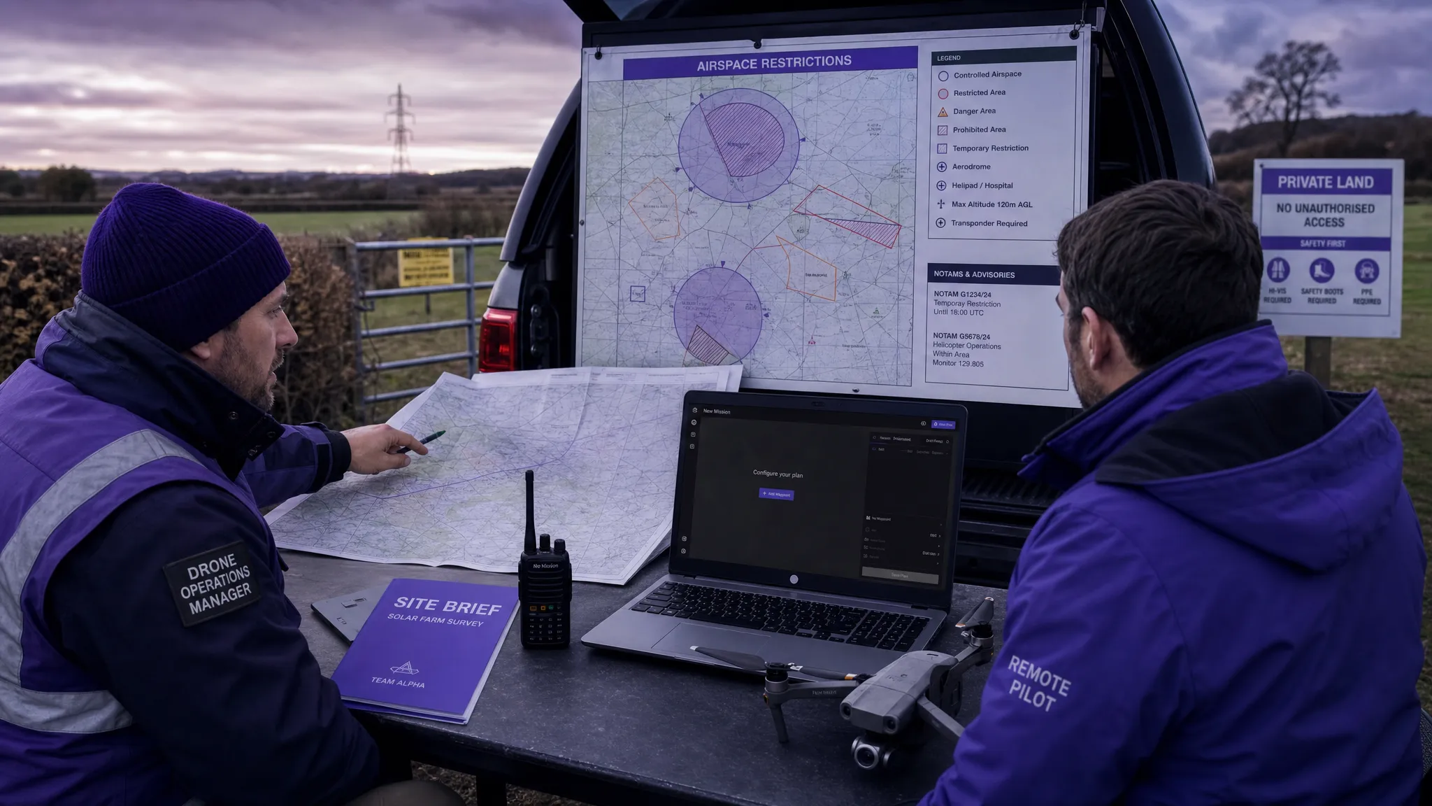 How to Use a Drone Flight Restrictions Map Safely →