A Drone Pilots Guide to Every Class of Airspace
Trying to make sense of the sky can feel like learning a new language. The best way to think about it is like a city with invisible highways, intersections, and restricted zones all stacked on top of each other.
A class of airspace is just a set of rules for a specific chunk of the sky. These rules dictate who can fly there, what gear they need, and what procedures they have to follow to make sure everyone stays safe. It’s the system that keeps massive airliners safely separated from small drones like yours.
Decoding The Sky: A Beginner's Guide To Airspace
The National Airspace System (NAS) is a complex but surprisingly logical network designed to prevent mid-air collisions and keep the skies orderly. For drone pilots, understanding this system isn't just a good idea—it's a legal must. At its core, the entire system boils down to two main categories that every remote pilot needs to get straight.
This flowchart breaks down the National Airspace System into its two basic types: Controlled and Uncontrolled. Everything else is built on this foundation.
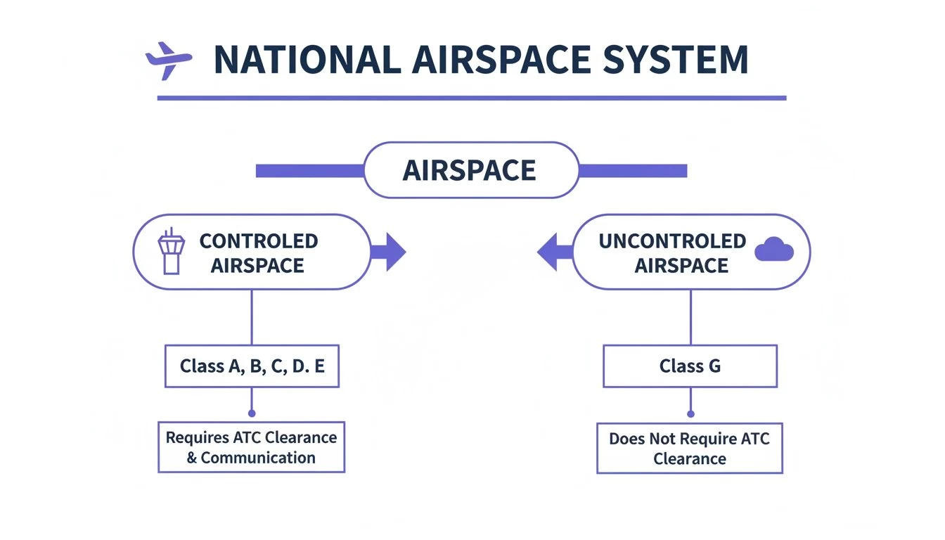
As you can see, the whole structure is designed to separate areas with active Air Traffic Control from those without. This simple division is the starting point for all flight rules.
Controlled vs. Uncontrolled Airspace
The most critical distinction you'll ever make is whether a piece of sky is controlled or uncontrolled. This one factor decides the level of regulation, what you need to say to whom, and whether you need permission to fly in the first place.
Controlled Airspace is any area where Air Traffic Control (ATC) services are actively provided. This covers the busy skies around airports where planes are constantly taking off and landing. Think of it as a managed freeway system with traffic cops directing the flow to keep things moving safely.
Uncontrolled Airspace, on the other hand, is where ATC does not exercise any authority. In these zones, pilots are on their own to maintain separation, operating under "see and avoid" principles. This is more like a quiet country road with way less traffic and fewer rules to worry about.
Why This Matters For Drone Operations
Getting this basic division right is the first step in planning any safe and legal drone mission. Flying in controlled airspace without the proper authorization can land you in serious trouble, including hefty fines and even losing your pilot certificate.
The good news is that most recreational flights and a lot of commercial drone work happen in uncontrolled airspace (Class G). However, many projects—especially in urban or industrial areas—will require you to operate inside controlled zones.
To get a feel for the bigger picture, it's worth knowing that global bodies like the ICAO set the international aviation standards that influence these national rules. You can learn more about the key players in this article on IATA Vs ICAO Key Differences.
Every class of airspace we’ll cover in this guide falls into one of these two foundational categories, each with its own set of operational rules you need to know cold.
Airspace Classes At A Glance For Drone Pilots
To make this a bit easier to digest, here's a quick-reference table summarizing the airspace classes you're most likely to encounter as a drone pilot.
| Airspace Class | Common Location | Controlled By | Drone Authorization Required? |
|---|---|---|---|
| Class B | Around the busiest major airports (e.g., LAX, JFK) | ATC | Yes, always |
| Class C | Around airports with a control tower and radar services | ATC | Yes, always |
| Class D | Around smaller airports with a control tower but no radar | ATC | Yes, always |
| Class E | Most other controlled airspace, often starting at 700' or 1,200' AGL | ATC | Yes, if flying in the controlled portion |
| Class G | Uncontrolled airspace, typically from the surface up to 700' or 1,200' AGL | None (Self-regulated) | No (unless other restrictions apply) |
This table is just a starting point. As we dive deeper into each class, you'll see there are more nuances to consider for every flight.
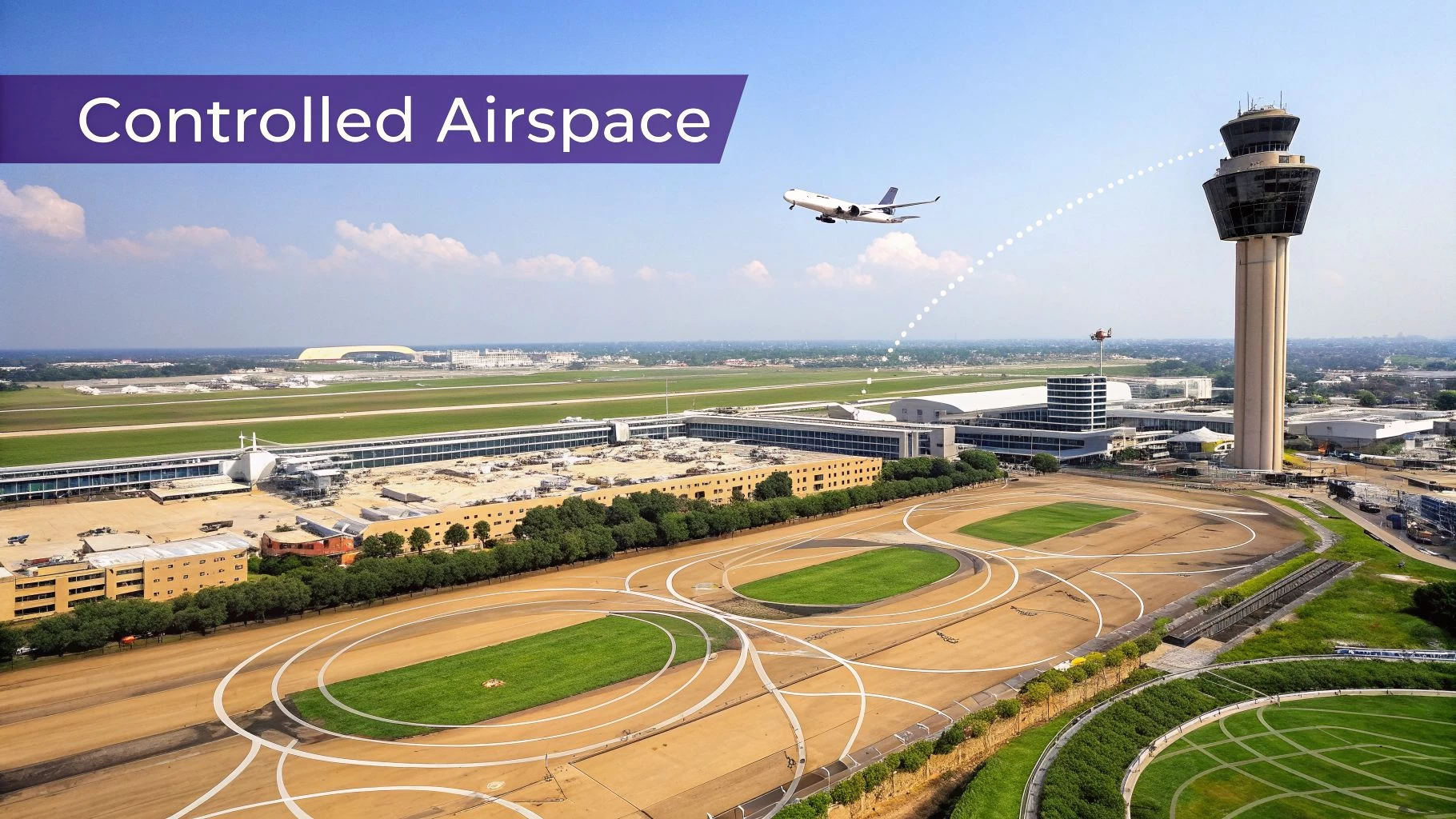
Navigating Controlled Airspace: Classes A, B, C, and D
Once you venture into controlled airspace, you’re flying on the sky's busiest highways, all managed by Air Traffic Control (ATC). This is where most commercial planes live and breathe, so the rules are, quite rightly, very strict. Think of these controlled zones—Classes A, B, C, and D—as protective bubbles around airports and at high altitudes, keeping manned aircraft safely separated.
For drone pilots, this is a whole different ball game. You can't just launch and fly; you need permission first.
Class A: The High-Altitude Freeway
Imagine Class A airspace as the exclusive expressway of the sky, reserved for the fastest, highest-flying jets. It covers everything from 18,000 feet Mean Sea Level (MSL) all the way up to 60,000 feet MSL.
Since drone operations are capped at 400 feet Above Ground Level (AGL), you’ll never find yourself planning a mission in Class A. It's good to know it exists as the ceiling of our national airspace system, but it won’t ever be a direct factor in your flight planning.
Class B: The Busiest Airport Hubs
Class B is the most complex and locked-down airspace you'll encounter as a drone pilot. It’s the protective bubble around the nation's biggest and busiest airports—think LAX, JFK, or Heathrow. The best analogy is an upside-down wedding cake, with layers that get wider the higher you go, creating a safe corridor for airliners on approach and departure.
- Structure: Typically extends from the surface up to around 10,000 feet MSL.
- Manned Aircraft Rules: Pilots need explicit ATC clearance just to enter. They also need specific equipment like a transponder with altitude reporting.
- Drone Pilot Rules: You must get authorization before flying anywhere inside Class B airspace. No exceptions. This is done through the Low Altitude Authorization and Notification Capability (LAANC) system.
Flying in Class B without the proper sign-off is a huge deal. With so many commercial airliners in a tight space, an unauthorized drone becomes a major safety hazard, and the aviation authorities enforce these rules to the letter.
Class C: Major Airports with Radar Services
Taking a step down in complexity, we find Class C airspace. This protects airports that are still very busy—often serving major regional cities—but not quite on the scale of a Class B hub. They have a control tower and are equipped with radar approach services.
The structure is like a smaller, two-tiered version of the Class B "wedding cake":
- Inner Core: A ring with a 5-nautical-mile radius, extending from the surface up to 4,000 feet above the airport.
- Outer Shelf: A wider ring with a 10-nautical-mile radius, sitting above the surrounding area from 1,200 feet up to 4,000 feet above the airport.
For drone pilots, the rules are just as serious as Class B. You must get LAANC authorization to fly anywhere within the lateral boundaries of Class C airspace, right from the ground up.
Class D: Smaller Airports with a Control Tower
Finally, there's Class D airspace. This is typically a simple cylinder of airspace around smaller airports that have an operational control tower but don’t have the radar services found at Class C and B facilities. It usually extends from the surface up to 2,500 feet above the airport, with a radius of about 4 nautical miles.
Even though it’s less complex, the active control tower means it’s still very much controlled airspace. As a drone pilot, you are required to get LAANC authorization before you even think about flying within Class D boundaries. For a deeper dive, take a look at our guide on how to read a Class D airspace map.
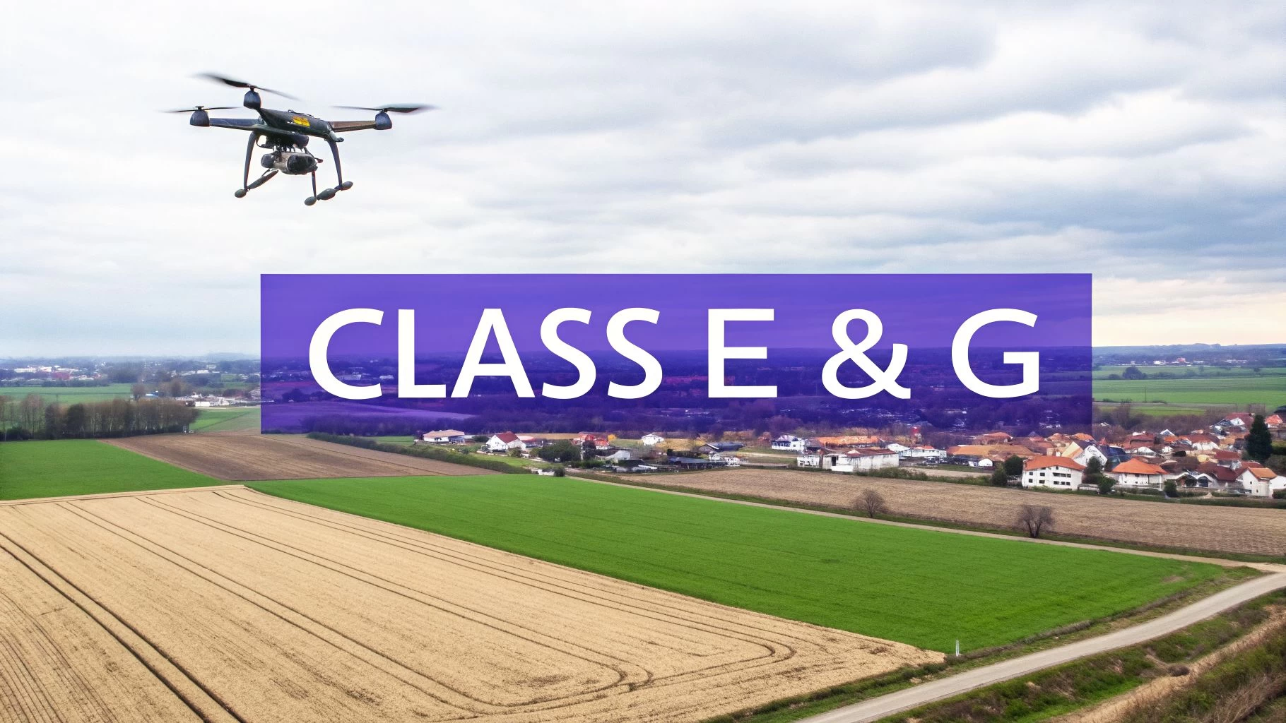
Flying in Your Primary Zones: Class E and G Airspace
Alright, let's move away from the complex, congested skies around major airports and get back to where most of us spend our time flying. This is the world of Class E and Class G airspace—the two classifications that will cover the overwhelming majority of your drone operations.
Getting a firm grasp on the subtle but critical differences between them is the key to flying safely, legally, and without jumping through unnecessary hoops.
If the busier airspace classes are the multi-lane motorways of the sky, think of Class G as the local country roads. It's where the traffic is lightest, and the rules are the most relaxed.
Class G: The Uncontrolled Default
Class G airspace is the only flavour of uncontrolled airspace in the United States. You can think of it as the default airspace—it’s what’s left over wherever Classes A, B, C, D, or E aren’t specifically designated.
Across most of the country, particularly in rural areas, Class G extends from the ground up to either 700 feet or 1,200 feet Above Ground Level (AGL).
The defining feature here is the total absence of Air Traffic Control (ATC) services. In Class G, pilots are on their own, responsible for spotting and avoiding each other.
For us drone pilots, this is fantastic news. It means you do not need ATC authorization to fly. You can get your jobs done freely, as long as you stick to all the other Part 107 rules, like staying below 400 feet AGL and keeping the drone in your sight.
Class E: The "Everywhere" Airspace
While Class G might feel like the default from the ground up, Class E is the true giant of the sky. This is controlled airspace that blankets the vast majority of the country.
It typically begins right where Class G leaves off, starting at either 700 or 1,200 feet AGL and stretching all the way up to 18,000 feet MSL, where Class A takes over. It’s the connective tissue that fills the gaps between airports, ensuring manned aircraft flying on instruments are always under ATC’s watchful eye.
Now, that might sound a bit intimidating, but there's a crucial detail every single drone pilot needs to burn into their memory.
The most important thing to know about Class E is this: even though it's technically "controlled", you generally do not need ATC authorization to fly in it, provided you stay below 400 feet AGL.
Why? Because your drone operation at 400 feet AGL is happening below the floor of where the controlled part of Class E usually begins (at 700 feet or higher). You’re effectively flying in the underlying Class G airspace. This simple fact opens up enormous areas for legal, authorization-free drone flights. But—and this is a big but—you must always verify the specific floor of Class E in your operating area.
When Class E Starts at the Surface
The big exception to that rule is when Class E airspace extends all the way down to the surface. This is common around smaller airports that don't have a control tower but do have published instrument approach procedures for manned aircraft. On a sectional chart, you'll see this marked with a dashed magenta line.
If your flight plan takes you inside one of these surface-level Class E zones, the game changes completely:
- Authorization is Mandatory: You must get ATC authorization, usually through LAANC, before you even think about taking off.
- Operating Altitude: The 400-foot buffer is gone. You need permission to be there at any altitude.
Learning to spot the difference between standard Class E and surface-level Class E is a non-negotiable skill for any professional drone operator. For a deeper dive on this, you can learn more about flying a drone in Class E airspace in our dedicated guide.
This isn’t just a suggestion; proper airspace intelligence is a hard requirement for compliant flying. Modern flight planning tools like Dronedesk make this analysis instant, taking the guesswork out of the equation and helping you avoid a very costly mistake.
Special Use Airspace and Other Critical No-Fly Zones
Beyond the familiar A through G airspace classes, there's another layer of complexity you absolutely have to account for—zones that carry invisible “Keep Out” signs. These areas are lumped together as Special Use Airspace (SUA), and they’re set aside for activities that could be flat-out hazardous to anyone not involved. For a drone pilot, blundering into one isn't just a mistake; it's a non-starter.
Getting your head around these zones is every bit as important as knowing your standard airspace classes. They’re there for a reason, whether it’s to protect national security, cordon off dangerous military exercises, or keep the skies clear during big public events. Flying into one without permission isn't a simple slip-up; it's a serious federal offence with equally serious consequences.
Prohibited and Restricted Areas
At the very top of the "don't even think about it" list are Prohibited and Restricted Areas. These are the heavy hitters of SUA, and you need to know the difference.
-
Prohibited Areas (P-###): Picture these as permanent, non-negotiable fortresses in the sky. Flight is completely forbidden, no exceptions, for national security reasons. We're talking about the airspace over places like the White House (P-56) and the U.S. Capitol. There's no scenario where a drone pilot can get a pass to fly here.
-
Restricted Areas (R-###): These zones are hot. They contain unusual and often invisible hazards like artillery firing, aerial gunnery, or guided missile tests. Unlike Prohibited Areas, you might be able to fly here, but only with explicit permission from the agency in charge.
Flying into a Restricted Area without clearance is the aviation equivalent of wandering onto a live firing range. The potential for a catastrophic outcome is incredibly high, and the legal penalties are designed to match that risk. Checking for these zones before every single flight is non-negotiable.
Military Operation Areas and TFRs
Not all of these critical zones are permanent fixtures on a map. Some are dynamic, popping up and disappearing based on what's happening on the ground. Two of the most common types you'll run into are Military Operation Areas (MOAs) and Temporary Flight Restrictions (TFRs).
A Military Operation Area (MOA) is a block of airspace set aside for military training, which can include things like high-speed aerobatic manoeuvres or formation flying. While you can technically fly a drone in an active MOA under VFR, it's an incredibly bad idea. The risk of a conflict with fast-moving military jets is just too high. The smart play is to always check an MOA's active hours and schedule your flight for another time.
A Temporary Flight Restriction (TFR) is even more fluid. These are short-term no-fly zones put in place by the FAA through a Notice to Air Missions (NOTAM). They can appear with very little warning for all sorts of reasons.
Common triggers for a TFR include:
- VIP Movements: For example, anytime the President is travelling.
- Major Sporting Events: Covering stadiums during NFL or MLB games.
- Natural Disasters: Over wildfires or hurricane recovery zones to keep the air clear for emergency crews.
- Public Events: Things like airshows or large festivals.
Because TFRs are temporary and location-specific, you won't find them on a standard aeronautical chart. This is exactly why relying on charts alone is a recipe for disaster. Professional pilots must use up-to-date airspace intelligence tools—like the ones built into Dronedesk—that pull real-time NOTAM data. These tools will flag any active TFRs that could affect your flight plan. Getting caught ignoring a TFR can lead to fines north of $20,000 and the immediate loss of your Part 107 certificate.
How to Automate Airspace Checks for Every Flight
Knowing the difference between Class B and Class G airspace is fundamental. But the real mark of a professional drone pilot isn’t just knowing the rules—it's applying that knowledge to every single mission, without fail.
Manually digging through sectional charts, checking for active NOTAMs, and pinpointing nearby airports is a massive time sink, and frankly, it’s prone to error. One small oversight is all it takes to commit a serious airspace violation. This is where modern drone operations platforms come in, transforming a painfully manual task into a slick, automated workflow.
From Manual Charts to Digital Intelligence
Forget spending hours poring over paper charts or bouncing between half a dozen websites. You can let specialized software do all the heavy lifting in seconds. This isn't just about making life easier; it’s about accuracy and covering your back. An automated system pulls real-time data from official sources, so your pre-flight checks are always based on the most current information out there.
Imagine you get a last-minute call to film a property near a regional airport. You need answers, fast. What's the airspace class? Do you need LAANC authorization? Are there any surprise TFRs? An automated platform gives you those answers instantly, so you can make a quick, informed decision.
Automated airspace analysis takes human error out of one of the most critical parts of flight planning. It ensures you never miss dynamic restrictions, like a pop-up TFR for a local event, protecting your certificate and your business from some very costly mistakes.
This approach lets you put your energy into the mission itself, knowing your compliance checks are rock-solid.
A Practical Flight Planning Scenario
Let's walk through a common job. A construction client needs progress photos of a site on the edge of a town with a small, tower-controlled airport. The old-school manual way would look something like this:
- Find the site on a VFR sectional chart.
- Figure out the exact Class D airspace boundaries around the airport.
- Head over to the FAA’s NOTAM website to check for TFRs or other restrictions.
- Pull up the LAANC grid map to see if you can get instant authorization.
That’s a lot of juggling between different tools and it eats up valuable time. With an integrated platform like Dronedesk, the whole process is a breeze. You just pop in the mission address, and the system instantly gets to work analyzing the location.
The Dronedesk platform gives you a clean, colour-coded map that lays out all the relevant airspace and ground hazards for your flight area.

In a single glance, you can confirm the site is inside Class D airspace, see the nearby airport, and spot any ground-based risks like schools or hospitals. The platform turns complex aeronautical data into intelligence you can actually use.
What Automated Airspace Checks Give You
A good drone operations platform does more than just show you a map. It pulls together multiple data sources into one comprehensive pre-flight briefing, giving you the complete operational picture. This tech is a cornerstone of modern drone safety management.
Here are the key data points you should expect from any solid automated system:
- Identified Airspace Class: A clear-cut statement on whether you're in Class B, C, D, E, or G airspace.
- Real-Time TFRs and NOTAMs: Flags for any temporary restrictions that you'd never find on a static chart.
- Airport and Heliport Proximity: Highlights of nearby air traffic facilities and their exact distance from your operation.
- Special Use Airspace Alerts: Warnings for any nearby MOAs, Restricted, or Prohibited areas.
- Ground Hazard Identification: Pinpoints for sensitive locations like schools, hospitals, and critical infrastructure.
By building these checks directly into your job planning, you create a repeatable, compliant process you can trust for every single flight. For a deeper dive, check out our full guide on Dronedesk’s airspace and proximity intelligence. This automated approach ensures your understanding of the class of airspace translates directly into safer, more efficient operations every time you fly.
Your Top Airspace Questions, Answered
Even after you’ve got a handle on the different airspace classes, the real world has a funny way of throwing curveballs during mission planning. Aviation is full of specific scenarios and little details that can trip you up. This section is all about tackling the most common questions drone pilots ask when they’re trying to connect the theory to the real world.
Getting straight answers to these sticking points is the key to flying with confidence. Let's break down some of the most critical ones.
How Can I Tell What Class of Airspace I Am In?
The most reliable way to figure out your airspace class is to use a current aeronautical chart, like a VFR Sectional, or a dedicated flight planning tool. These maps are the official source, laying out all the airspace boundaries visually.
On these charts, you'll see a web of lines and colors. For instance, solid blue circles typically mark out Class B airspace, while dashed magenta lines show you where Class E airspace starts right at the ground level.
For any professional pilot, though, the quickest and most foolproof method is using a drone operations platform. A system like Dronedesk completely automates this. It instantly scans your flight area and gives you a simple, clear report on all airspace classes and restrictions, taking all the guesswork out of the equation.
This approach doesn't just save time; it dramatically cuts the risk of misreading a complex chart.
What Is the Difference Between Controlled and Uncontrolled Airspace?
The single biggest difference boils down to one thing: the presence of Air Traffic Control (ATC). It's a simple distinction, but it has massive implications for how you operate.
In controlled airspace (that's Classes B, C, D, and most of E), ATC is actively managing traffic to keep everyone safely separated. This is exactly why you often need to get prior authorization or be in communication to fly there.
On the other hand, in uncontrolled airspace (Class G), ATC provides no services at all. Pilots are entirely on their own to maintain separation, mostly by using the "see and avoid" principle. For drone pilots, Class G offers the most freedom, but all the standard FAA rules—like staying below 400 feet—still apply.
Do I Always Need Authorization in Controlled Airspace?
Not always, but the answer depends entirely on the specific airspace class and how high you plan to fly. This is a crucial detail that trips up a lot of new pilots.
For any flight inside Class B, Class C, and Class D airspace, you always need ATC authorization, period. It doesn’t matter what altitude you're at. The most common way to get this is through the automated LAANC system.
The rules for Class E are a bit more forgiving. In most Class E airspace, you generally don't need authorization if you stay below 400 feet AGL. That’s because you're flying well underneath the "floor" of the controlled airspace, which usually starts at 700 or 1,200 feet. But—and this is a big but—if Class E extends all the way to the surface at your location, then authorization becomes mandatory. For commercial pilots, a rock-solid understanding of airspace is non-negotiable, especially for jobs like drone inspection services.
What Happens If I Accidentally Fly into Restricted Airspace?
Let’s be blunt: flying a drone into restricted or prohibited airspace without authorization is a serious federal offense. The consequences are designed to be severe because the risks are so high.
The fallout can vary based on the specific airspace and the nature of the flight, but you could be looking at:
- Hefty FAA Fines: We’re not talking about a slap on the wrist. These fines can easily run into the tens of thousands of dollars for a single flight.
- Certificate Action: The FAA can suspend or even permanently revoke your Part 107 remote pilot certificate, which means your commercial flying career is over.
- Criminal Charges: If you stray into airspace protecting sensitive national security locations, you could face criminal prosecution.
This is precisely why using a reliable, up-to-the-minute airspace intelligence tool before every single flight isn't just a good idea—it's an absolute necessity. It’s about protecting your license, your business, and national security. It's a risk that is never, ever worth taking.
Ready to stop guessing about airspace and streamline your entire drone operation? Dronedesk gives you instant, automated airspace and proximity intelligence, so you can plan every mission with confidence and total compliance. Simplify your workflow and get back to what you do best—flying.
 FAA Remote ID Rule Explained for Commercial Pilots →
 Drone Legal Requirements for Commercial Operations →
 Drone Near Airport Rules Explained for Safer Planning →
 International Drone Regulations Every Global Team Should Know →
 Drone Flight Risk Assessment Example for Safer Missions →
 Beyond Visual Line of Sight Explained for Operators →
 How BVLOS Drone Operations Change Commercial Workflows →
 FAA Drone Rules Every Commercial Pilot Should Know →
 FAA 107 Explained for Commercial Drone Operators →
 Canadian Drone Regulations Explained for Business Use →