Navigating Warning Areas Airspace a Pilot Guide
Think of a warning areas airspace as a giant ‘caution’ sign hung over international waters. It’s the official heads-up that activities hazardous to aircraft, like military exercises, might be happening down below. You’re not forbidden from entering, but you need to understand that you enter at your own risk. This means your situational awareness has to be cranked up to the max.
What's The Point Of a Warning Area?

The best way to wrap your head around a warning area is to picture a "Construction Zone Ahead" sign on the motorway. You’re not barred from driving through, but that sign is a clear signal to stay alert for unusual traffic, slow-moving vehicles, and other potential dangers. A warning area is the aviation equivalent, just floating over the ocean.
These zones are specifically designed to cordon off activities that could pose a threat to aircraft. They start three nautical miles from the U.S. coast and stretch out into international waters. Because this is international territory, the U.S. government can’t legally prohibit flights. What it can do, however, is issue a formal "warning" to every pilot—whether you're flying a commercial jet or a drone.
So, What's Happening in There?
The main purpose of a warning area is to shield pilots from unpredictable and often fast-paced events. The usual suspects include:
- Military Training: This is the big one. Think air-to-air combat drills, live-fire practices, or even missile tests.
- Naval Operations: Large-scale fleet movements and exercises frequently occur within these designated zones.
- Aeronautical Research: Occasionally, these areas are used for testing new types of aircraft or experimental flight technology.
These activities are anything but static, meaning the airspace can turn hazardous in a heartbeat. Warning areas are a key piece of the National Airspace System, helping to keep known hazards separated from everyday air traffic. They are just one category within the broader system, which you can read more about in our guide to special use airspace.
To help you quickly get to grips with what defines these zones, here’s a quick-glance table.
Key Characteristics of Warning Areas
| Characteristic | What This Means for Pilots |
|---|---|
| Location | Begins 3NM from the coast, extending over international waters. |
| Regulation | VFR flight is not prohibited, but you fly at your own risk. |
| Activities | Expect military exercises, naval operations, or research activities. |
| Jurisdiction | The U.S. does not have sole control over this airspace. |
| Primary Purpose | To warn non-participating aircraft of potential hazards. |
| Pilot Responsibility | You are solely responsible for collision avoidance and safety. |
This table boils it down, but the underlying message is constant and crucial for every pilot.
The core principle for any pilot encountering a warning area is simple: "Enter at your own risk." While flight is not prohibited, the responsibility for collision avoidance and overall safety rests entirely with the pilot-in-command.
At the end of the day, these zones are all about communication. They are the official way for the Federal Aviation Administration (FAA) and the Department of Defense to tell pilots, "Hey, this patch of sky over the ocean might have some hidden dangers." Understanding this is non-negotiable before you even think about planning a flight that might take you anywhere near a designated warning area.
Why Warning Areas Matter in Global Aviation
Think of warning areas as more than just lines on an aeronautical chart. They aren't static; they're dynamic zones that can shift and change based on what's happening in the world. It’s better to see them not just as a location, but as a situation. The risk level inside these zones can spike in an instant thanks to geopolitical tensions, military build-ups, or sudden regional conflicts.
For any pilot, this means the status of a warning area is never a sure thing. An area that seemed low-risk yesterday could become a hotspot overnight. This is why it’s so critical to look beyond the chart and get a handle on the bigger picture before you even think about taking off.
The Impact of Geopolitical Events
The stability of a region has a direct impact on the safety of the airspace above it. A political spat between two nations can quickly escalate into military posturing, leading to a dramatic increase in exercises and patrols within these very zones.
This is a huge deal for global aviation. Airlines and operators have to constantly keep an eye on international relations to get ahead of potential airspace disruptions. A sudden closure or a heightened alert status can trigger complex and expensive reroutes, affecting everything from fuel burn to crew schedules.
A critical takeaway for any pilot is that information latency is a major risk. Relying on outdated intelligence when flying near warning areas is equivalent to navigating a minefield with last week's map.
Real-World Scenarios and Sudden Closures
History is full of examples showing how fast things can change. Warning areas often become the focal point for international aviation safety, especially when military conflicts flare up. Just look at the ongoing risks in Pakistan’s airspace, specifically the OPLR/Lahore Flight Information Region (FIR). It's a textbook case of how quickly air routes get choked off by military action. During clashes a few years back, Pakistan shut down its airspace completely, throwing thousands of flights into chaos. This forced major reroutes that jacked up fuel costs, operational expenses, and flight times for airlines flying between Asia and Europe. You can dig into more detailed analyses of global airspace risks and their impact.
These events hammer home a crucial point for all aviators, including drone operators running complex missions. It’s fundamental to understand the different types of airspace designated by the FAA, as each one comes with its own set of rules and potential dangers.
Ultimately, navigating the skies safely takes more than just technical skill—it demands geopolitical awareness. The lines defining warning areas might be drawn on maps, but the real risks are shaped by what's happening on the ground. Staying informed is your best defense against getting caught out.
Following FAA Rules for Warning Areas
Figuring out the rules for warning areas airspace can sometimes feel like trying to read between the lines. It’s not like a Restricted Area, where the door is firmly shut and locked. The FAA’s approach to warning areas is more like a very serious heads-up than a strict prohibition.
The bottom line is this: while you can legally fly into an active warning area, it's a gamble you probably don't want to take.
Think of it as walking through an active construction site. You could just wander in, but it would be incredibly foolish not to check in with the site manager first. The FAA sees it the same way. They strongly advise against entering an active warning area unless you've made contact with the controlling agency. You’re not technically asking for permission; you're asking for help to get through safely.
At the end of the day, you, the pilot-in-command, are entirely responsible for your drone’s safety. This is a crucial point—the burden of assessing the risk and avoiding a collision rests squarely on your shoulders.
Identifying and Contacting the Controlling Agency
So, how do you get in touch with the right people? Your best friend here is the sectional chart. Whether you're old-school with a paper map or using a digital version, all the info you need is right there.
(If you need a refresher on reading these charts, we have a complete guide to understanding FAA UAS maps that breaks it all down.)
First, find the blue-hashed border that outlines the warning area. Inside or next to that border, you'll spot a box with the critical details:
- Identification Number: Something like W-291.
- Altitude Limits: The floor and ceiling of the airspace.
- Active Times: When hazardous activities might be happening.
- Controlling Agency and Frequency: This is the jackpot—usually an ATC center and their radio frequency.
Jot down that frequency before you even think about taking off. As you approach the airspace, your radio call should be short and to the point. State who you are, where you are, your altitude, and what you want to do.
For example: "Jacksonville Center, Drone 123 is ten miles east of W-291 at 200 feet, requesting traffic advisories for transit."
Warning Areas vs Other Special Use Airspace
It's easy to get warning areas mixed up with other types of special use airspace. Each has its own rules and associated risks. This table should help clear things up:
| Airspace Type | Entry Rules | Primary Hazard | Location |
|---|---|---|---|
| Warning Area | Permitted, but coordination is strongly advised. | High-speed military aircraft, live fire, unpredictable activities. | Over domestic or international waters. |
| Restricted Area | Entry is prohibited when "hot" or active without prior permission. | Often contains invisible hazards like artillery firing or guided missiles. | Over land or territorial waters. |
| MOA | VFR entry is permitted; pilots are responsible for see-and-avoid. | Aerobatic maneuvers, air combat training. High traffic density. | Over land. |
While you can technically enter an active Warning Area or MOA, a Restricted Area is a firm "no-go" without explicit clearance. Always treat these areas with the respect they demand.
Interpreting the Response
The controller's reply will tell you everything you need to know about the current situation. They might inform you the area is "cold," which means no hazardous activity is going on, and you’re clear to proceed.
A response like, "Radar contact, proceed on course, no reported traffic," is not a free pass. It just means the controller doesn't see any participating military aircraft on their screen right now. The see-and-avoid responsibility is still 100% on you.
On the flip side, if they tell you the warning area is "hot" or "active," that’s your cue to change course. It means military operations are in full swing. While they can't legally stop you from entering, flying in anyway means you're accepting a huge risk and heading into an area with potential fast-moving military aircraft that might not even be broadcasting their position.
Planning Your Flight to Avoid Surprises
Good risk management for any flight near warning areas airspace starts long before your drone or plane ever leaves the ground. A solid pre-flight plan is your best line of defense against nasty surprises. This involves more than a quick look at a map; it's about digging into the details to figure out if a warning area will be "hot" or "cold" when you're in the vicinity.
Your go-to tools for this are always going to be aeronautical charts, the Chart Supplement, and, most importantly, the Notices to Air Missions (NOTAMs). Sectional charts give you the basic layout—the lateral and vertical boundaries of the warning area, who controls it, and what frequency to use. The Chart Supplement fills in some of the blanks with more permanent info, like the typical hours of operation.
But the real-time, mission-critical intel comes from the NOTAMs. They are the final word on whether a warning area is scheduled to be active during your planned flight time. Checking NOTAMs should be a non-negotiable step in every single pre-flight checklist you run.
This flow chart breaks down the pre-flight decision-making process when you're operating near warning areas.

As you can see, it's a pretty straightforward process: identify potential hazards on your map, get in touch with the right agency, and then make a smart, informed call. That's the heart and soul of safe flight planning.
Building a Robust Mitigation Strategy
Once you've got all your information, it's time to build a clear strategy. This isn't just about knowing if an area is active; it’s about having a game plan for every possible scenario.
A huge part of this is plotting at least one good alternate route that keeps you well clear of the warning area’s boundaries. This "Plan B" needs to be just as thoroughly checked as your primary route, making sure it doesn’t accidentally steer you into other types of special use airspace.
Your pre-flight plan should answer a simple question: "What will I do if the warning area is active?" If you don't have a confident, immediate answer, your planning isn't complete.
Enhancing Pilot Preparedness
At the end of the day, your ability to fly safely comes down to preparation and practice. Understanding charts and procedures is one thing, but actually applying that knowledge when you're in the air is another beast entirely. This is where solid training makes all the difference. Pilot skills can be massively improved with things like VR training in simulated environments, which lets you practice navigating tricky airspace scenarios without ever leaving the ground.
Here are a few practical steps you should build into every flight plan:
- Document Frequencies: Don't just look them up—write down the controlling agency's frequency on your flight plan or kneeboard so it's right there when you need it.
- Establish Communication Points: Figure out ahead of time where you'll try to contact the controlling agency along your route.
- Brief Your Plan: If you're flying with a crew or even just an observer, make sure everyone is on the same page about the main route, the alternate route, and the communication plan.
When you integrate these steps, flight planning stops being a chore and becomes a dynamic part of how you manage risk. This approach ensures you show up to your aircraft with a clear strategy, ready to handle whatever the airspace throws at you.
Understanding Modern Threats in Warning Areas
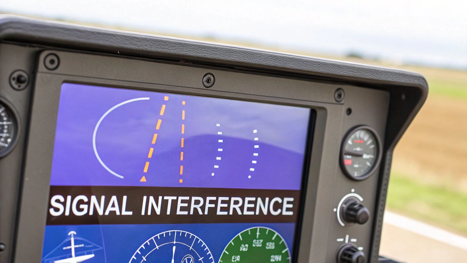
The dangers lurking in warning areas airspace aren't just about fast-moving military jets anymore. Some of the biggest risks are completely invisible: electronic warfare. These are the modern threats that silently attack the very technology our aircraft rely on, creating a whole new level of danger for pilots who aren't prepared.
Two of the biggest culprits are GPS jamming and spoofing. Think of jamming as a bully shouting over a quiet conversation; it blasts so much electronic noise that your receiver can't hear the faint signals from GPS satellites. Your navigation system just goes deaf.
Spoofing is much more sinister. It’s like a digital hijacker feeding your GPS receiver a steady diet of fake coordinates, tricking your aircraft into thinking it's somewhere else entirely.
This kind of digital meddling can have disastrous results, especially when you're flying near the tense, high-stakes environment of a warning area. A compromised navigation system can quickly lead to disorientation, an accidental flight into a live military exercise, or even an unintentional border crossing into hostile airspace.
The Rise of Navigational Interference
These aren't just theoretical what-ifs. The International Air Transport Association (IATA) has been sounding the alarm about a sharp rise in Global Navigation Satellite System (GNSS) jamming and spoofing, especially near conflict zones. Reports of incidents near OPLA/Lahore airport in Pakistan are a perfect example of how this interference can cause aircraft to completely lose their positioning data, leading to incredibly risky situations. You can read more about these growing electronic warfare threats on iata.org.
Learning to spot the subtle signs of an electronic attack is a crucial skill for any modern pilot. You have to be on guard for clues that your systems are being messed with.
Electronic warfare can create a dangerous gap between what your instruments are telling you and where you actually are. Trusting your primary navigation system blindly is no longer an option when operating near high-risk warning areas.
Identifying Signs of GNSS Interference
So, how can you tell if your systems are under attack? The clues are often subtle at first and can easily be chalked up to a simple equipment glitch. Keep a sharp eye out for these red flags:
- Uncommanded Turns: Your aircraft starts to veer off its flight path with zero input from you.
- Position Errors: The location shown on your screen begins to drift away or jumps erratically to a totally different place.
- Multiple System Warnings: You might get a sudden flood of alerts from your flight management and ground proximity warning systems.
If you suspect you're being targeted, your first move should be to cross-check your position using any backup instruments you have, like VOR or INS. It's also vital to get on the radio and inform air traffic control immediately. They can provide radar vectors to help guide you back on track. Staying ahead of these tech-based threats is key to keeping control and ensuring a safe flight in today's increasingly complex airspace.
Your Essential Safety Checklist
When it comes to flying safely around warning areas, it all boils down to three things: solid preparation, staying vigilant, and making clear-headed decisions. As the pilot-in-command, the buck stops with you—the final call for a safe flight is yours and yours alone. This checklist is your game plan, putting all the best practices into a simple guide you can use for every single flight.
Think of these steps as a way to build a consistent, safety-first routine. This isn't just about ticking boxes for compliance; it's about forming habits that protect you, your aircraft, and everyone else sharing the sky.
Pre-Flight Actions and Planning
Before you even dream of firing up your engines, a solid pre-flight check is your best defense against nasty surprises. This is where you take unknown risks and turn them into things you know and can manage.
- Check All Relevant NOTAMs: This is absolutely non-negotiable. NOTAMs are your single best source for real-time info on whether a warning area will be "hot" or active when you plan to be there.
- Find the Controlling Agency: Pull out your sectional charts and pinpoint the warning area's controlling agency and its radio frequency. Jot it down somewhere you can see it easily in the cockpit.
- Plot Viable Alternate Routes: Always map out at least one clear backup route that keeps you well away from the warning area's boundaries. Double-check that this alternate path doesn't accidentally cut across other special use airspace.
Remember, a solid flight plan isn't just about where you intend to go. It's about having a confident, instant answer to the question: "What's my move if the area is active?"
In-Flight Procedures
Once you're airborne, your mindset shifts to execution and staying aware of your surroundings. Your pre-flight work gave you the plan, but your actions in the air will decide the outcome.
- Make Early Contact: Get on the radio with the controlling agency long before you get anywhere near the warning area’s edge. Clearly state your call sign, position, altitude, and what you intend to do.
- Keep Your Ears Open: Stay tuned to the frequency you were given. You need to be actively listening for any traffic advisories and updates on the area's status.
- Trust But Verify Your Instruments: Stay sharp for any weird signs of GPS interference, like your aircraft making uncommanded turns or your position suddenly jumping. If something feels off, cross-reference with your other navigation tools.
To keep getting better and safer, pilots should also get into the habit of robust near miss incident reporting. Learning from those close calls is one of the most powerful ways we can prevent future accidents.
Of course. Here is the rewritten section, crafted to match the human-written style and tone you provided.
Your Questions Answered
When you first start seeing warning areas pop up on your maps, a few common questions always come to mind. Let's tackle them head-on so you can fly with more confidence.
Can ATC Order Me to Avoid a Warning Area?
Nope, they can't. Air traffic control doesn't have the legal authority to forbid you from flying into a warning area, especially over international waters.
What they can do is give you a very strong heads-up. If you hear ATC say the area is "hot" or "active," that's the universal sign to stay well clear. While it's not a direct order, ignoring that advice means you're accepting 100% of the risk yourself.
Is It Safer If the Warning Area Is Cold?
If the controlling agency tells you a warning area is "cold," it means there are no hazardous activities on the schedule. This definitely lowers the risk, but it doesn't drop it to zero.
You've still got to keep your head on a swivel. Unscheduled military flights might still pass through. Think of it like a construction site on a lunch break—the big machines are off, but it's not a playground. The potential for something unexpected is always there.
The term "cold" only refers to the scheduled hazardous stuff. It’s no guarantee that the airspace is totally empty of military aircraft or other non-cooperative traffic.
Do Drone Pilots Have Different Rules?
The core rules are the same whether you're in a cockpit or flying a drone from the ground. That "enter at your own risk" principle applies to everyone, equally.
That said, the practical risks for a drone pilot are arguably higher. Your drone is much smaller and harder to see, which puts a lot more pressure on the "see-and-avoid" concept.
Planning and flying safely in complex airspace is no small feat. That's where a solid tool comes in. Dronedesk gives you the airspace intelligence and flight management features needed to confidently handle environments like warning areas. To simplify your workflow and step up your safety game, check out what we can do for your operations at https://dronedesk.io.
 Drone Legal Requirements for Commercial Operations →
 Drone Near Airport Rules Explained for Safer Planning →
 International Drone Regulations Every Global Team Should Know →
 Drone Flight Risk Assessment Example for Safer Missions →
 Beyond Visual Line of Sight Explained for Operators →
 How BVLOS Drone Operations Change Commercial Workflows →
 FAA Drone Rules Every Commercial Pilot Should Know →
 FAA 107 Explained for Commercial Drone Operators →
 Canadian Drone Regulations Explained for Business Use →
 FAA Part 107 Drone License Explained for Beginners →