UAV Flight Planner - Transform Your Drone Operations
Mastering UAV Flight Planners: Beyond Basic Controls

The world of drone technology is constantly evolving, and with it, the way we plan and execute drone missions. At the heart of this progress lies the UAV flight planner, a tool that separates professional drone operations from amateur endeavors. These platforms have come a long way, transforming from simple waypoint systems to sophisticated mission control centers. This shift has significantly impacted how professionals approach drone operations in various industries.
Early flight planners mainly focused on plotting basic flight paths. Now, modern UAV flight planners offer a comprehensive suite of tools for mission management. This includes features such as terrain following, automated payload control, and real-time flight monitoring. These advancements provide operators with greater control, efficiency, and more accurate data. This highlights the increasing importance of software in fully realizing the potential of drone technology.
The professional drone community is increasingly recognizing the value of dedicated planning software. These platforms are essential for successful drone programs. They streamline workflows and boost operational efficiency. Investing in robust flight planning tools, despite the associated learning curve, demonstrates a commitment to precision and professionalism.
UAV flight planners have dramatically improved the efficiency and accuracy of drone operations. Advanced planners allow for precise flight path optimization, ensuring consistent altitude and speed, vital for applications like LiDAR surveys. This precision can reduce mission time by up to 30% and increase data accuracy. The drone adheres closely to the planned path, improving overall efficiency. For a deeper dive into this topic, discover more insights about flight planning and LiDAR.
Understanding the Advantages of Professional Flight Planning
Advanced features set professional UAV flight planners apart from basic control apps. These capabilities provide significant advantages in complex operational environments. For instance, terrain-following algorithms allow drones to maintain a constant ground sampling distance, even over challenging terrain. This ensures consistent data quality regardless of topographical variations.
Intelligent battery management systems calculate mission feasibility before takeoff. This critical feature prevents in-flight power failures, ensuring mission completion. By accurately predicting battery consumption based on the flight plan, operators can confidently execute missions without the risk of data loss or aircraft damage.
Many professional UAV flight planners facilitate multi-drone coordination, allowing operators to manage several drones simultaneously for complex missions. This collaborative approach significantly enhances operational scope and efficiency, particularly in large-scale mapping or surveillance. These sophisticated features demonstrate the potential of professional UAV flight planners in optimizing drone missions for maximum impact.
Essential Features That Define Professional UAV Flight Planners

Professional UAV flight planners offer a significant step up from basic consumer apps. They provide a suite of powerful features that are essential for professional drone operators. Understanding these key features is crucial for selecting the right platform for your specific needs.
Terrain Following and Ground Sampling Distance
A core difference lies in terrain-following capabilities. This technology allows the UAV to maintain a constant ground sampling distance (GSD), even over uneven terrain. Imagine surveying a hilly landscape. A basic flight planner might maintain a fixed altitude, leading to inconsistent GSD and potentially impacting data accuracy.
A professional UAV flight planner equipped with terrain following dynamically adjusts the drone's altitude. This ensures consistent GSD and uniform data resolution across the entire survey area. This is especially important for applications like precision agriculture or infrastructure inspections.
Intelligent Battery Management
Intelligent battery management is another vital aspect. This goes beyond simply indicating remaining battery life. Advanced systems analyze the planned mission, considering factors like distance, altitude changes, and wind speed. This allows for precise battery consumption predictions before takeoff.
Operators can then assess mission feasibility and prevent mid-flight power failures. Such failures can result in data loss or even aircraft damage. Pre-flight battery analysis is key to ensuring safe and successful missions.
Multi-Drone Coordination
For complex tasks, multi-drone coordination is invaluable. Professional flight planners enable operators to manage multiple drones at once. This significantly expands operational capacity, facilitating efficient data collection over large areas. It also allows for coordinated missions involving various payload types.
For example, one drone might capture high-resolution imagery, while another simultaneously collects LiDAR data. All this is managed through a single interface. This synchronized approach significantly boosts efficiency and data gathering capabilities. For further insights on drone mission planning software, check out this helpful resource: How to master drone mission planning software.
Payload Integration and Customization
Professional UAV flight planners prioritize payload integration. They support a wide array of sensors and other equipment. This lets operators tailor missions to their specific needs. This flexibility extends beyond basic payload control to include automated workflows for data acquisition and processing, significantly streamlining complex operations.
Evaluating Platforms Based on Operational Needs
Choosing the right UAV flight planner requires careful consideration of your operational needs. Don't just rely on marketing materials. Instead, assess the types of missions you typically conduct, the terrain you operate in, and your specific data requirements.
The following table summarizes the key features discussed and compares their availability across different tiers of UAV flight planning platforms:
UAV Flight Planner Feature Comparison Across Tiers
Comprehensive breakdown of capabilities between entry-level, mid-range, and enterprise UAV flight planning platforms
| Feature | Basic Planners | Intermediate Planners | Professional Planners |
|---|---|---|---|
| Terrain Following | Limited or None | Basic Terrain Following | Advanced Terrain Following with GSD Control |
| Battery Management | Basic Battery Level Indicator | Flight Time Estimation | Intelligent Battery Prediction based on Mission Parameters |
| Multi-Drone Coordination | Not Supported | Limited Support for 2-3 Drones | Full Support for Multiple Drones with Coordinated Missions |
| Payload Integration | Limited to Basic Payloads | Support for Common Payloads | Extensive Payload Support with Customized Integration |
The table above clearly highlights the increasing sophistication of features as you move from basic to professional flight planning platforms. The ability to control GSD, predict battery usage accurately, coordinate multiple drones, and integrate diverse payloads are hallmarks of a professional system.
By carefully evaluating platforms based on these criteria, you'll select a tool that truly enhances your workflow and contributes to mission success. This ultimately leads to a more productive and effective drone program.
Flight Path Optimization: The Science Behind Efficient Missions

Smart flight planning is essential for getting the most out of your drone. It's not simply about reaching your destination quickly; it's about maximizing efficiency. This means understanding the algorithms that drive efficient route planning and recognizing how small tweaks can lead to big improvements. Professional drone operators use UAV flight planners to strike a balance between competing factors such as battery life, required data resolution, and desired coverage area.
Balancing Competing Priorities
One of the biggest challenges in UAV flight planning is balancing the need for thorough data collection with the drone's limited battery life. For instance, increasing image overlap improves the quality of 3D models generated through photogrammetry, but it also drains the battery faster. Similarly, flying at lower altitudes results in higher resolution data, but it requires longer flight paths and consumes more power.
Good UAV flight planners help operators find the optimal balance. They offer fine-tuned control over parameters like overlap and ground sampling distance (GSD), allowing users to customize flight plans to their specific needs. This empowers operators to maximize data quality while staying within the drone's operational limits.
The Power of Terrain-Adaptive Missions
Terrain following is a valuable feature in UAV flight planning. In areas with varying elevations, a flight plan at a fixed altitude can lead to inconsistent GSD and potentially compromise data accuracy. Terrain-adaptive missions, on the other hand, adjust the drone's altitude dynamically to maintain a constant distance from the ground.
This technology is crucial for a wide range of applications, from surveying mountainous terrain to inspecting infrastructure such as pipelines and power lines. By maintaining consistent GSD, terrain-adaptive missions ensure uniform data quality, regardless of the terrain below. This is essential for producing accurate maps, models, and subsequent analysis.
Intelligent Obstacle Avoidance and Optimal Coverage
Intelligent obstacle avoidance is another critical aspect of flight path optimization. Advanced UAV flight planners incorporate data from various sources, including terrain maps and airspace restrictions, to automatically create flight paths that avoid collisions. This enhances safety and reduces the need for manual intervention, allowing operators to focus on other important tasks.
UAV flight planners also typically use algorithms to optimize coverage patterns. For example, during a mapping mission, the planner can automatically generate a flight path that covers the entire target area with minimal overlap. This reduces both flight time and battery consumption. Moreover, the use of UAV flight planners has contributed to significant improvements in drone maintenance and performance. By analyzing flight logs and planning data, as discussed here, operators can identify potential problems before they become critical. If a drone consistently consumes more power than anticipated during specific maneuvers, the flight planner can reveal this pattern and suggest adjustments to the flight plan or maintenance schedule.
Metrics for Evaluating Mission Efficiency
Analyzing mission efficiency is key to continually improving operations. Key metrics include flight time, battery consumption, data acquisition rate, and coverage area. By reviewing these metrics after each mission, operators can pinpoint areas for improvement and refine their flight planning strategies. This iterative process leads to more efficient and effective drone operations over time.
Industry-Tailored UAV Flight Planning Strategies

A UAV flight planner isn't one-size-fits-all. Different industries have unique needs, demanding specific flight planning strategies. Understanding these industry-specific requirements is crucial for optimizing drone operations and achieving desired outcomes. This means considering everything from data collection to regulations.
Agriculture: Optimizing For Growth Stages
In agriculture, timing is key. UAV flight planners are essential for capturing data at crucial growth stages. A farmer might use a flight planner to capture multispectral imagery at regular intervals throughout the growing season. This data monitors crop health, identifies problem areas, and optimizes irrigation and fertilization.
Flight planners also enable consistent data collection, vital for accurate analysis and year-over-year comparisons. Flight parameters like altitude and overlap are crucial for consistent imaging. This precision helps farmers identify low-yield areas or pest infestations, allowing for prompt intervention and minimizing losses.
Construction: Documenting Progress and Managing Resources
Construction projects greatly benefit from regular aerial monitoring. UAV flight planning software like Dronedesk helps create missions that capture comprehensive site documentation. This data provides valuable insights into project progress, resource allocation, and potential safety hazards.
A construction team can use a UAV flight planner to schedule regular flights, monitoring progress and tracking operations. This real-time visibility helps project managers identify bottlenecks, optimize workflows, and maintain schedules. This translates to significant cost savings and improved project outcomes.
Conservation: Balancing Monitoring and Minimal Disturbance
Balancing data needs with minimal environmental impact is paramount in conservation. UAV flight planners create flight plans that minimize wildlife disturbance while collecting vital ecological data, allowing researchers to observe animal populations from a safe distance.
Consider monitoring endangered species. A UAV flight planner can design a mission that surveys nesting sites without disturbing the animals. This balances data collection with minimizing human impact on sensitive ecosystems, making drones valuable tools for researchers.
To illustrate industry-specific flight planning, let's look at some expert-recommended parameters and considerations.
Industry-Specific UAV Flight Planning Requirements
Expert-recommended flight parameters and considerations across major drone application sectors
| Industry | Flight Pattern | Optimal Altitude | Special Considerations | Data Output |
|---|---|---|---|---|
| Agriculture | Grid, Double Grid | Dependent on sensor and desired GSD | Overlap, flight timing synchronized with crop growth stages | Multispectral imagery, NDVI maps |
| Construction | Linear, Crosshatch | Varies based on site size and detail requirements | Airspace restrictions, site safety protocols | Orthophotos, 3D models, progress reports |
| Conservation | Waypoint, Corridor | Minimize disturbance to wildlife; dependent on observation targets | Environmental regulations, sensitive habitats | Aerial imagery, wildlife population data |
The table highlights how flight patterns, altitudes, and considerations vary drastically between industries. From the grid patterns used in agriculture to the waypoint navigation crucial for conservation, tailoring your approach is essential.
Choosing the right UAV flight planner and adopting an industry-tailored strategy are essential for maximizing the potential of drone technology. By understanding these specific requirements, operators can increase efficiency, gather superior data, and make informed decisions. This leads to safer, more effective, and impactful drone operations across diverse industries.
Seamless Workflows: UAV Flight Planner to Deliverable
A well-crafted flight plan is only as good as the usable data it generates. This section explores how modern UAV flight planners integrate with processing workflows, creating seamless data pipelines from initial planning to the final deliverable. We'll examine how strategic planning decisions directly influence processing outcomes and discuss optimization techniques for specific deliverables.
Optimizing Planning Decisions for Processing Outcomes
Effective UAV flight planning significantly impacts data processing efficiency. Consistent image overlap, for instance, is crucial for photogrammetry software like Metashape, to create accurate 3D models. A UAV flight planner helps automate this process, ensuring appropriate overlap throughout the mission. This reduces manual adjustments during post-processing and streamlines the overall workflow. Additionally, setting the correct ground sampling distance (GSD) during the planning phase ensures the captured data meets the required resolution for the final product.
Automating Data Management for Error Reduction
Features like automatic geotagging and integrated logging within UAV flight planners eliminate tedious manual steps. This automation reduces potential errors and significantly speeds up post-processing. Imagine manually geotagging hundreds of images after a survey mission! This time-consuming task is prone to human error. UAV flight planners automate geotagging, embedding precise location data within each image file. This not only saves time but also ensures data accuracy, essential for generating reliable deliverables. Learn more in our article about How to master drone flight planning.
Building End-to-End Workflows for Data Integrity
Leading drone operators are developing end-to-end workflows that maintain data integrity from capture to client presentation. This approach minimizes post-processing difficulties and ensures consistency and reliability across all projects. Imagine a construction company monitoring a project’s progress. By integrating their UAV flight planner with their project management software, they can automatically upload geotagged images and create progress reports.
This seamless workflow eliminates the need for manual data transfer and ensures all stakeholders have access to the most current information, significantly enhancing efficiency and communication within the project team.
Metadata Management: The Key to Efficient Post-Processing
Metadata management is crucial for streamlining post-processing. Modern UAV flight planners automatically embed essential information, such as flight parameters, camera settings, and environmental conditions, directly into the data. This rich metadata context allows processing software to automatically optimize its algorithms, improving results and reducing processing time.
For instance, knowing the precise camera angle and lighting conditions during image capture enables photogrammetry software to produce more accurate 3D models. This automated metadata management is essential for optimizing post-processing workflows.
Real-World Examples of Integrated Workflows
Consider a search and rescue operation. A UAV flight planner can be used to define a search grid, taking into account terrain and obstacles. The drone captures real-time video and imagery, automatically geotagged with location information. This data is then streamed to a command center where it is analyzed immediately to locate and assist individuals in need. This streamlined workflow can be the difference between a successful rescue and a tragic outcome.
Another example involves using drones for infrastructure inspection. By incorporating pre-defined flight paths and automated reporting features, a UAV flight planner can generate detailed inspection reports immediately after the mission. This ensures timely identification of potential issues, minimizing downtime and ensuring infrastructure safety.
These examples demonstrate the critical role of UAV flight planners in bridging the gap between capturing data and generating valuable deliverables. By automating tasks, ensuring data integrity, and optimizing workflows, these tools enhance efficiency, accuracy, and ultimately, the value of drone operations across diverse industries.
Navigating Compliance With UAV Flight Planners
UAV flight planners are indispensable tools for navigating the complex world of drone regulations. They're not just about efficiency; they're your key to safe and legal drone operations. These platforms incorporate critical airspace information, regulatory restrictions, and important safety parameters. This proactive approach ensures compliance and unlocks more commercial opportunities.
Integrating Airspace Information and Regulatory Restrictions
Modern UAV flight planners integrate real-time airspace data, including no-fly zones, restricted areas, and temporary flight restrictions (TFRs). This dynamic data is crucial for avoiding hazardous situations and maintaining compliance. For instance, a UAV flight planner can automatically notify you of a TFR in your planned flight area, allowing for timely adjustments.
Furthermore, many planners include regulatory information, such as maximum altitude limits and area-specific restrictions. By presenting this information upfront, these tools help operators stay informed and compliant, minimizing potential penalties and operational delays.
Simplifying Regulatory Adherence With Automated Features
Many UAV flight planners simplify regulatory adherence through automated features. Automated authorization requests streamline the permission process for flights in controlled airspace, eliminating manual paperwork and reducing administrative burden.
Geofencing integration creates virtual boundaries within the flight planner, preventing drones from entering restricted areas. This added safety net is especially beneficial in complex or sensitive environments. These automated features make compliance more manageable, letting operators focus on their mission.
Flight Log Documentation and Operational Transparency
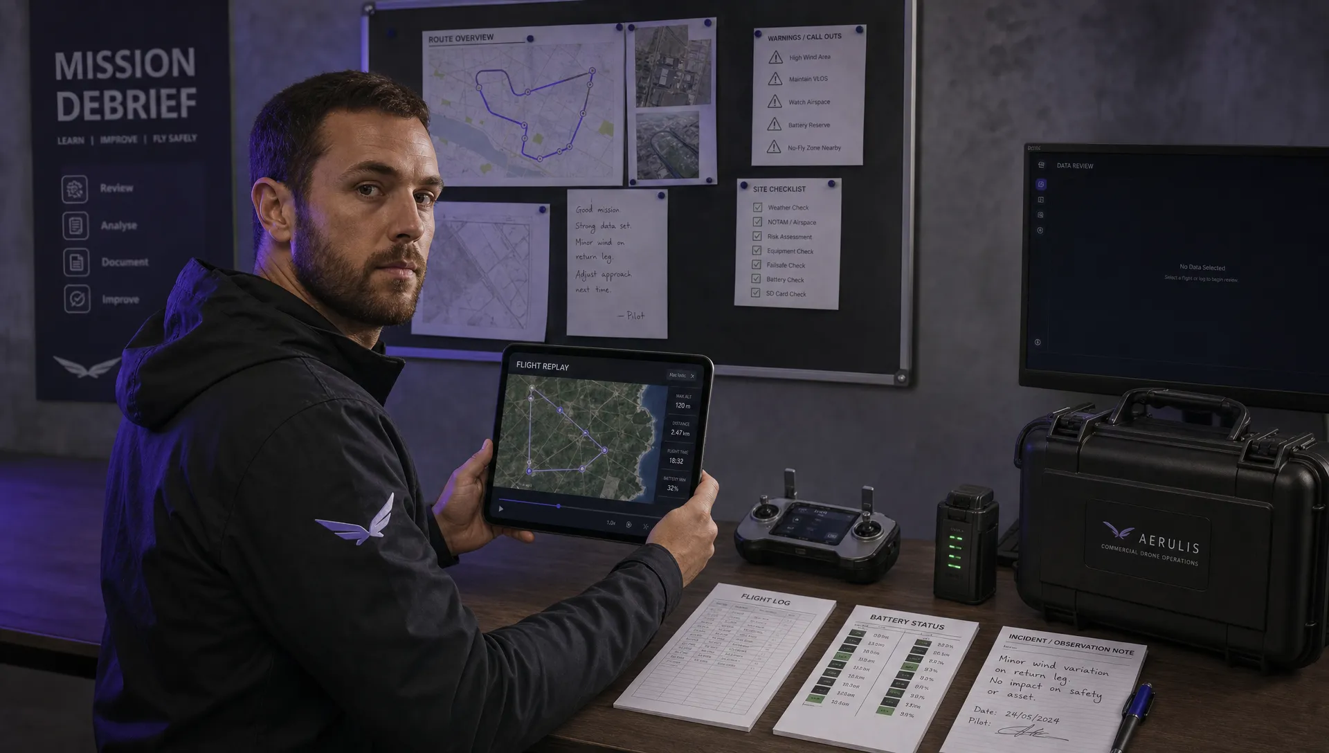
Accurate flight logging is essential for demonstrating compliance. UAV flight planners automatically generate detailed flight logs, recording flight paths, altitudes, speeds, and other pertinent data. This thorough record-keeping is crucial for incident investigations and audits. Imagine needing to reconstruct a flight path after an incident; a detailed log is invaluable evidence, potentially protecting you from liability.
This data is also valuable for operational improvement. Analyzing flight logs helps operators identify patterns, optimize future missions, and enhance overall safety. You might find this resource helpful: How to master drone regulations.
Strategic Advantages of Compliance Planning
Proper compliance planning offers substantial strategic advantages. Demonstrating a commitment to regulatory compliance builds trust with clients and partners, especially when pursuing commercial opportunities. Insurance providers also favor operators who prioritize safety and adhere to regulations, potentially leading to lower premiums and improved coverage.
A robust compliance record also strengthens your position in case of an incident. Comprehensive documentation demonstrates regulatory adherence and mitigates potential legal challenges. This proactive approach builds resilience and safeguards your business.
UAV Flight Planners as Compliance Tools
Using your UAV flight planner as a compliance and documentation system offers numerous advantages. It streamlines workflows, reduces administrative work, and ensures operational transparency. By integrating compliance features into your flight planning, you're not just meeting requirements; you're establishing a foundation for a safe, sustainable, and successful drone operation. This strategic approach positions your business for growth and protects your investment in the evolving drone technology landscape.
The Evolution of UAV Flight Planning: What's Next
The future of UAV flight planning is just around the corner, promising a significant change from the tools we rely on today. Emerging technologies are set to reshape mission planning, presenting exciting new opportunities for drone operations. This evolution is fueled by progress in artificial intelligence, sensor technology, and cloud computing.
AI-Assisted Route Optimization: Adapting to Change
Imagine a drone mission that adapts to changing conditions in real time. AI-assisted route optimization is making this a reality. These systems analyze environmental data like weather patterns, wind speeds, and unexpected obstacles. This allows the UAV flight planner to dynamically alter the flight path, ensuring mission success even in unpredictable circumstances. For instance, a delivery drone could reroute around a sudden downpour, guaranteeing the package arrives safely and on schedule.
Advanced Obstacle Detection: Transforming Urban Operations
Urban environments pose specific challenges for drone operations. Advanced obstacle detection systems are changing how we navigate these complex areas. By combining sensors like LiDAR and computer vision, these systems generate a detailed 3D map of the surrounding area. This allows the UAV flight planner to accurately maneuver around buildings, trees, and other obstacles, enabling safe and efficient urban drone operations. This opens up possibilities for new applications such as complex deliveries or inspections in densely populated locations.
Cloud-Based Collaborative Planning: Enabling Enterprise Workflows
Collaboration is essential in enterprise drone operations. Cloud-based flight planning platforms allow multiple users to access and modify mission plans concurrently. This real-time collaboration simplifies workflows and enhances decision-making. Imagine a team planning a large-scale infrastructure inspection. Cloud-based planning enables engineers, surveyors, and project managers to work together on the flight plan, ensuring all needs are addressed and data is gathered efficiently. This collaborative method improves communication, minimizes potential conflicts, and ultimately increases the value of drone data.
Preparing for the Future of UAV Flight Planning
These developing technologies will significantly influence how we plan and execute drone missions. Staying ahead requires understanding how these capabilities can benefit your operations. By evaluating your specific requirements and exploring the latest innovations in UAV flight planning technology, you can make informed choices about platform selection and capability development. This proactive strategy sets your operation up for success in the rapidly changing drone industry. This involves assessing your present and future needs to guarantee you choose a UAV flight planner capable of adapting to the evolving demands of your operations.
Ready to enhance your drone operations with a robust and future-proof platform? Explore Dronedesk, the comprehensive drone operations management platform designed for professionals. Dronedesk offers advanced features, smooth integrations, and adaptable solutions to help you streamline workflows, enhance safety, and maintain compliance in the dynamic world of drone technology.
 How to Review a DJI Flight Record After a Mission →
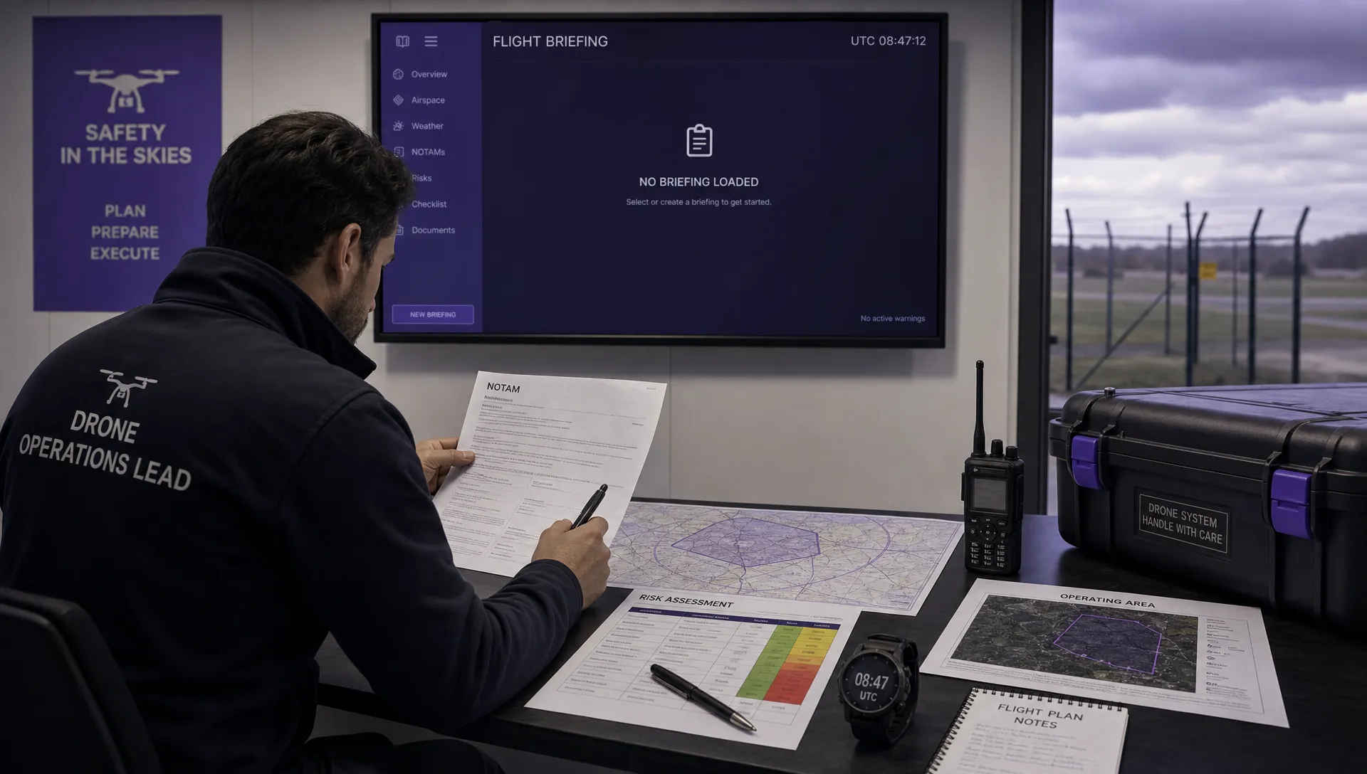 How to Check a Drone NOTAM Before You Fly →
 Part 108: What Drone Operators Should Expect →
 Beyond Visual Line of Sight BVLOS Explained →
 Drone Laws and Regulations Every Team Should Review →
 Current Drone Laws: What Changed in 2026? →
 JARUS SORA Explained in Plain English →
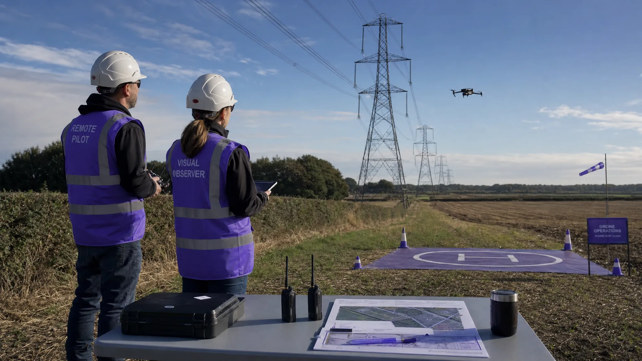 Drone Visual Line of Sight Rules Explained →
 Drone Regulations Checklist for Commercial Flights →
 Drone Flying Laws: A Practical Guide for Operators →