Mastering Traffic Pattern Altitude for Safe Flights
The Traffic Pattern Altitude (TPA) is the specific altitude aircraft fly in a standardized rectangular loop around an airport just before landing. Think of it as a designated "lane" in the sky, usually set at 1,000 feet above the ground. This simple rule ensures every pilot follows a predictable path, which is a massive win for safety and efficiency in busy airspace. It’s the very foundation of orderly airport operations.
The Highway in the Sky Explained
Picture the airspace around an airport. Without clear rules, it would be pure chaos. The Traffic Pattern Altitude is the elegant solution to that potential mess. It establishes a consistent altitude—a specific "lane"—for all arriving and departing aircraft to follow, turning what could be a free-for-all into a smooth, predictable flow of traffic.
This system is absolutely vital for keeping aircraft separated, not just from each other but also from towers, trees, and buildings on the ground. When everyone flies at the same relative height, pilots know exactly where to look for other planes. This predictability eases the mental workload, especially during the critical approach and landing phases, letting them focus on what matters most: flying the plane.
Core Components of the Traffic Pattern
The traffic pattern itself is a rectangular course flown around the runway. Every segment, or "leg," of this pattern serves a specific purpose, and the whole circuit is flown at the established TPA.
This infographic breaks down how the key legs—downwind, base, and final approach—fit together, all flown at that consistent altitude.
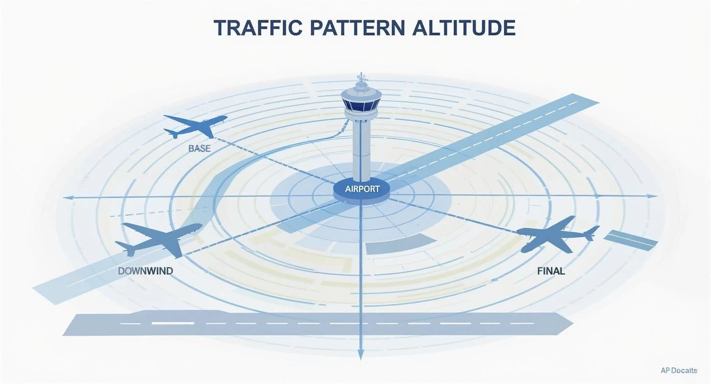
As you can see, the TPA creates an organized "box" around the runway that guides aircraft through a safe and systematic landing sequence. Each leg perfectly sets up the pilot for the next step, ensuring a stable, controlled approach.
At its core, the traffic pattern altitude is a simple, yet powerful, agreement among pilots. It's a mutual understanding that says, "This is where we will be," creating a transparent and safe environment for everyone operating near the airport.
Globally, the standard TPA for most general aviation aircraft is 1,000 feet above ground level (AGL), but this isn't set in stone. Major commercial airports often use higher pattern altitudes, sometimes 1,500 feet AGL or even more. This helps accommodate faster, heavier aircraft and keeps them safely separated from slower traffic. This kind of altitude stacking is crucial as global air travel grows, a trend you can explore further with data from Airports Council International.
Different Altitudes for Different Aircraft
It's a simple fact: not all aircraft fly the same. A small Cessna has vastly different performance characteristics than a corporate jet, so they can't safely share the exact same airspace "lane." To solve this, airports often establish different TPAs for various aircraft categories. This vertical segregation is a fundamental safety feature.
The table below gives you a quick reference for typical traffic pattern altitudes based on aircraft type, illustrating how the system creates separation.
Standard Traffic Pattern Altitudes by Aircraft Category
| Aircraft Category | Typical TPA (AGL) | Primary Use Case |
|---|---|---|
| Piston Single/Multi-Engine | 1,000 feet | General aviation, flight training, personal travel |
| Turbine/Jet Aircraft | 1,500 feet | Corporate travel, charter flights, regional jets |
| Large Transport Aircraft | 1,500 - 2,500 feet | Commercial airlines, cargo operations |
| Helicopters & Gliders | 500 - 800 feet | Specialized ops, often using separate or modified patterns |
This tiered approach ensures that faster, larger aircraft can operate efficiently without conflicting with the slower traffic flying at lower pattern altitudes.
Why Predictable Altitudes Are Critical for Air Safety
Imagine driving down the motorway if there were no set speed limits or lane markings. It would be absolute chaos. That's pretty much what the airspace around an airport would be like without a Traffic Pattern Altitude (TPA). The TPA is the invisible lane marker in the sky, making sure every pilot is playing by the same rules.
Sticking to the published TPA is the single most effective way to prevent mid-air collisions. When every aircraft in the pattern flies at the same altitude, it creates a predictable, layered environment that everyone can count on. Pilots flying under Visual Flight Rules (VFR) live by the "see and avoid" principle, and knowing other planes will be at a specific height makes that possible. They know exactly where to scan the sky.
This standard altitude gets rid of the dangerous guesswork. It lets pilots anticipate what other aircraft are going to do with a high degree of confidence. Without it, you'd have planes approaching the airport at all sorts of heights, turning the sky into a three-dimensional free-for-all where the risk of a collision would skyrocket.
Creating Order from Chaos
Picture a busy, non-towered airport on a clear Saturday morning. Without a standard TPA, one pilot might decide to fly their downwind leg at 800 feet, while another comes in at 1,200 feet. Then, a third, faster aircraft might descend right through both of those altitudes. You can see how quickly that creates a frighteningly unpredictable mix of flight paths.
This is exactly the kind of mess a TPA is designed to prevent. The established altitude puts everyone on the same page, flying a consistent rectangular path around the runway. This shared procedure is the bedrock of safe flying, especially at airports that don't have an active air traffic control tower.
The benefits go well beyond just avoiding collisions:
- Reduces Pilot Workload: During the critical landing phase, pilots can focus on checklists and landing the plane safely, not trying to figure out where the aircraft next to them is headed.
- Enhances Situational Awareness: Knowing the TPA helps pilots build a mental map of where other traffic should be, making it far easier to spot them.
- Improves Airport Capacity: An orderly flow of traffic means more aircraft can safely use the airport, which boosts overall efficiency without cutting corners on safety.
The traffic pattern altitude is a pact of predictability. It’s a simple rule that creates a powerful safety net, ensuring that every pilot in the vicinity of an airport is speaking the same language of altitude and intention.
A Buffer for the Unexpected
Beyond normal day-to-day flying, a consistent TPA provides a vital safety margin when things go wrong. If a pilot runs into trouble—say, a partial engine failure or a dodgy instrument—being at a known, safe altitude gives them precious time and space to troubleshoot the problem.
Trying to manage an in-flight issue while dodging unpredictable traffic would be a nightmare. The TPA gives a pilot a clear, obstacle-free zone to maneuver, declare an emergency if needed, and figure out a safe way back to the runway. This buffer can be the difference between a minor incident and a serious accident. For more on how incidents are documented, check out our guide on the importance of an aviation safety reporting system.
This predictability is also key when conditions change. Weather is a huge factor in aviation, with the FAA noting a 40% increase in weather-related delays recently. The FAA's own plans for handling bad weather often involve using alternate, predictable altitudes to keep traffic moving. You can read more about their strategy in the 2025 Summer Air Traffic Operational Summit Readout. It’s a perfect example of why standardized altitudes are a cornerstone of modern air safety.
How to Find the Correct Traffic pattern Altitude
Knowing what a traffic pattern altitude is is one thing, but finding the actual number for your flight is a critical part of your pre-flight checks. Fortunately, you don't have to guess. Aviation authorities publish this information in several reliable sources, so the correct altitude is almost always just a few clicks or page turns away.
Your first stop should always be your primary flight planning resources. For pilots in the United States, the go-to document is the Chart Supplement (you might remember it as the Airport/Facility Directory). This publication is packed with detailed information for every public-use airport and is the official source for all operational data, including the TPA.

Unlocking the Chart Supplement
Think of the Chart Supplement as the airport's official biography. When you look up an airport, you'll find a block of text filled with essential data. The traffic pattern altitude is usually listed under "AIRPORT REMARKS" or a similar section and will typically be presented in Mean Sea Level (MSL), which is what your altimeter shows.
For instance, an entry might state: "PATTERN ALTITUDE: 2500 MSL." That's your number. If it only lists an AGL altitude (like "1000 AGL"), you’ll need to do a quick bit of math.
Calculating Your Target Altitude
The difference between AGL (Above Ground Level) and MSL (Mean Sea Level) is a crucial distinction. AGL is simply the height above the airport's ground, whereas MSL is the height above the sea. Since your altimeter is set to MSL, you have to fly your pattern based on an MSL value.
Here's the simple formula you'll use every single time:
Airport Field Elevation (MSL) + Pattern Altitude (AGL) = Target Pattern Altitude (MSL)
Let's walk through a real-world example. Imagine you're flying into an airport with a field elevation of 1,500 feet MSL. The standard pattern altitude is 1,000 feet AGL.
Using the formula: 1,500 ft (Airport Elevation) + 1,000 ft (AGL) = 2,500 ft (Target TPA in MSL)
So, your target altitude to fly in the traffic pattern is 2,500 feet MSL. This simple calculation is a fundamental part of every pre-flight briefing.
Using Sectional Charts and EFBs
While the Chart Supplement is the definitive source, other tools can give you this information in a more visual way. Sectional charts—the detailed maps pilots use for VFR flight—often include TPA information right on the chart. If you want to get better at spotting these details, check out this great guide on how to read sectional charts.
These days, modern Electronic Flight Bag (EFB) apps like ForeFlight or Garmin Pilot make this even easier. These powerful tools pull all the necessary data into one place. When you tap on an airport, the EFB displays a summary page that includes:
- Runway information and current winds
- The airport elevation, listed clearly
- The published TPA in both MSL and AGL
This integration cuts out a lot of the manual work, but it’s still vital to understand where the data comes from and how to calculate it yourself. After all, technology can fail, but fundamental knowledge won’t.
What to Do When No Altitude Is Published
Now and then, you might plan a flight to a smaller airport that doesn't have a published TPA. This can feel a bit uncertain, but there’s a standard, accepted procedure to follow.
If there’s no published altitude, the universally recognized convention is to fly the pattern at 1,000 feet AGL. For turbine or jet aircraft, the standard is a bit higher at 1,500 feet AGL. This predictable default ensures that even without specific instructions, pilots can maintain a safe and orderly flow of traffic.
When approaching an airport with no published TPA, your situational awareness becomes even more critical. Keep your ears open on the Common Traffic Advisory Frequency (CTAF), listen for other aircraft, and clearly announce your own position and intentions. Sticking to the 1,000-foot AGL convention is the safest, most predictable thing you can do.
Comparing Manned Aircraft and Drone Altitudes
As more drones take to the skies, it’s absolutely critical to understand the different operating "lanes" for traditional aircraft and unmanned aerial systems (UAS). While they both share the airspace, they're governed by completely different sets of rules designed to keep them safely apart. This is especially true near airports, where manned aircraft activity is most concentrated.
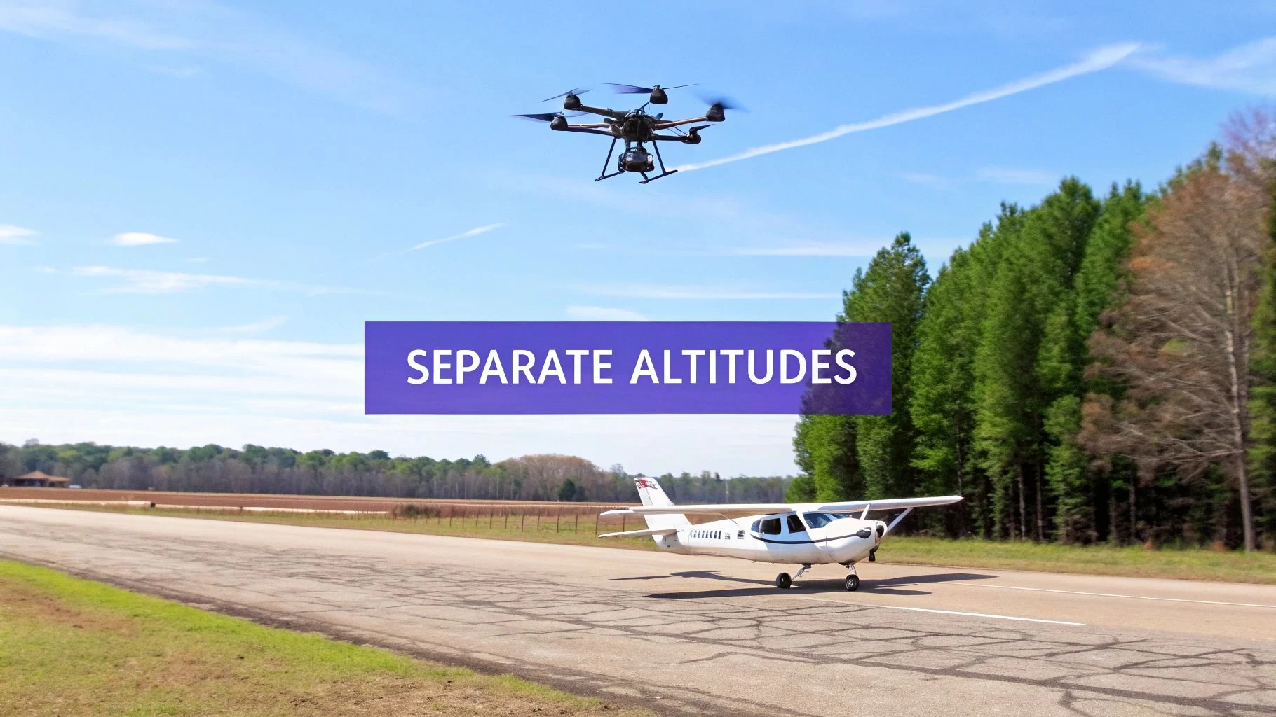
Think of it like different floors in a skyscraper. Manned aircraft flying a traffic pattern are on a higher floor, typically around 1,000 feet above ground level (AGL). Drones, on the other hand, are confined to the lower levels, which creates a vital vertical buffer between them.
The 400-Foot Ceiling for Drones
Under the FAA's Part 107 rules, which cover most commercial drone operations in the US, drones must fly at or below 400 feet AGL. This isn't just a random number; it’s a carefully chosen altitude that builds in a crucial safety margin.
This 400-foot ceiling creates a 600-foot buffer between the highest a drone can legally fly and the standard traffic pattern altitude. This vertical separation is really the foundation of safe, integrated airspace. And while drones don't fly a "traffic pattern" in the traditional sense, their pilots must know exactly where those patterns are to steer clear of any potential conflict.
The rules are black and white: drones must always give way to manned aircraft. If you see or even hear an airplane or helicopter nearby, your immediate response should be to land the drone safely and wait for the all-clear. For a deeper dive, our guide to drones and airspace is essential reading for any operator. https://blog.dronedesk.io/drones-and-airspace/
The core principle is simple: manned aircraft have established, predictable flight paths near airports, and drones must operate well below these paths to prevent interference. Think of the traffic pattern as a protected zone that UAS operations must never breach.
To put this in perspective, here’s a quick comparison of the rules for each type of aircraft when operating near an airfield.
Manned vs Unmanned Aircraft Altitude Regulations Near Airports
| Parameter | Manned Aircraft (in pattern) | Drones (UAS) |
|---|---|---|
| Typical Altitude | 1,000 feet AGL | At or below 400 feet AGL |
| Airspace Access | Follows established ATC procedures and traffic patterns. | Requires LAANC authorization in controlled airspace. |
| Right of Way | Has the right of way over all unmanned aircraft. | Must yield the right of way to all manned aircraft. |
| Primary Responsibility | Aviate, navigate, communicate. | "See and avoid"; maintain separation from other aircraft. |
As you can see, the operational frameworks are designed to keep these two types of aircraft in completely separate vertical spaces, with the primary burden of avoidance placed firmly on the drone pilot.
Why This Vertical Separation Is Non-Negotiable
The consequences of a mid-air collision between a drone and a manned aircraft could be catastrophic. This is especially true at lower altitudes during takeoff or landing, when an aircraft is moving slower and has less room to recover from an emergency like an engine ingestion or a windshield strike.
This is why drone pilots flying anywhere near an airport have to be extra vigilant. It's not just about staying below 400 feet; it’s about maintaining constant situational awareness of everything happening in the sky around you. The responsibility for "see and avoid" falls heavily on the drone pilot because, frankly, the crew of a manned aircraft might not see a small drone until it's far too late.
A Practical Checklist for Drone Pilots Near Airports
Flying a drone near an airport isn't off-limits, but it demands strict procedures and a proactive mindset toward safety. Before you even think about taking off, run through a pre-flight checklist to make sure you're operating safely and legally.
Here’s a quick-reference checklist to get you started:
- Check Airspace with B4UFLY: First things first, use the FAA’s official B4UFLY app. It gives you real-time info on airspace restrictions and TFRs at your planned location.
- Obtain LAANC Authorization: If you plan to fly in controlled airspace (Class B, C, D, or E), you must get authorization through the Low Altitude Authorization and Notification Capability (LAANC) system. This is non-negotiable and lets ATC know you're there.
- Visualize the Airport's Traffic Pattern: Pull up sectional charts or an Electronic Flight Bag (EFB) to spot the runways and picture where the traffic pattern is likely to be. Remember, it's usually a rectangular path around the airport at 1,000 feet AGL.
- Listen for Traffic: If you can do it safely, use a handheld aviation radio to monitor the airport's Common Traffic Advisory Frequency (CTAF). This will give you priceless insight into the movements of manned aircraft.
- Always Yield the Right of Way: Your number one job is to see and avoid other aircraft. If you even think an aircraft is nearby, bring your drone down to a lower altitude or land it immediately. Never, ever assume the other pilot sees you.
Common TPA Mistakes and How to Avoid Them
Even the most careful pilots can make simple mistakes with traffic pattern altitude, especially when things get busy. Knowing what these common slip-ups are is the first step to building better, safer habits. These aren't just minor technical points; getting them right is crucial for preventing conflicts in the air.
Most of these errors pop up during high-workload moments, like when you're entering the pattern or setting up for landing. One moment of distraction or a quick miscalculation can put you at the wrong altitude, creating a hazard for everyone. The goal is to make the correct procedures second nature through solid pre-flight planning and consistent practice.
For Manned Aircraft Pilots
Pilots deal with all sorts of things that can throw them off the correct TPA, from changing weather to plain old human error. Steering clear of these common mistakes helps you stay predictable and safe in the pattern.
1. Messing Up the MSL Calculation This one’s a classic. It’s easy to mix up AGL (Above Ground Level) with MSL (Mean Sea Level). If you forget to add the airport's field elevation to the standard 1,000 feet AGL pattern altitude, you’ll end up flying way too low, putting you in conflict with other traffic and obstacles.
- The Fix: Make calculating the TPA in MSL a non-negotiable part of your pre-flight briefing. Scribble the final MSL number on your kneeboard or punch it into your EFB as a reminder. For an airport at 1,200 ft elevation, your target TPA is 2,200 ft MSL. Simple as that.
2. Flying a "Creative" Pattern Entry Trying to join the pattern on the base leg or flying a straight-in approach without talking to anyone is a recipe for disaster. It surprises other pilots, and surprises are the last thing you want in an airport environment. The standard 45-degree entry to the downwind leg exists for a reason: it makes you visible and your intentions clear.
- The Fix: Unless ATC tells you otherwise, always plan for a standard 45-degree entry. A great technique is to overfly the field 500 to 1,000 feet above the TPA. It gives you a bird's-eye view to check the windsock, spot other traffic, and set yourself up for a perfect, predictable entry.
A predictable pilot is a safe pilot. The traffic pattern isn't just a suggestion; it's a choreographed sequence designed to keep everyone separated. Adhering to standard procedures is your most important contribution to collective safety.
3. Drifting Off Altitude Due to Distraction It happens. You're running through checklists, configuring the plane for landing, and scanning for traffic, and before you know it, you've drifted off your altitude. But even a deviation of 100-200 feet is a big deal. It shrinks your safety buffer, especially when you have a mix of slower piston planes and faster turbine aircraft sharing the pattern at different altitudes.
- The Fix: Nail that TPA and hold it firm. If your aircraft has an altitude-hold function on the autopilot, use it. If not, make your altimeter a key part of your scan throughout every leg of the pattern.
For Drone Operators
As a drone pilot, you have a massive responsibility to stay clear of airport operations. The consequences of getting it wrong are just too high.
1. Flying Too Close to Airport Operations A lot of drone pilots think they're safe because they're flying legally under 400 feet AGL. What they don't realize is how close that can be to the flight paths of aircraft on final approach or takeoff. Think of the traffic pattern as a big, invisible box around the airport—you need to stay well clear of it.
- The Fix: Pull up an aviation chart before you fly. Get a visual on where the pattern is likely to be. The best practice is to give the airport and its extended runway centerlines a wide berth, even when you're flying well below your legal altitude ceiling.
2. Misunderstanding What LAANC Does Getting a LAANC authorization to fly in controlled airspace doesn't mean you own the sky. It's just a way of letting ATC know you're there. Some operators mistakenly think it gives them a free pass to fly without constantly watching for manned aircraft.
- The Fix: Think of LAANC as a permission slip to operate with extreme vigilance. Your number one job is, and always will be, to see and avoid other aircraft. If you see or hear a plane or helicopter, the right move is to land your drone immediately. It is your legal and moral duty to give way.
Common Questions About Traffic Pattern Altitude
Flying brings up a ton of questions, especially around something as fundamental as traffic pattern altitude. Let's tackle some of the most common ones that pop up for both GA pilots and drone operators.
Think of this as your go-to guide for those "what-if" moments. We’ll cover situations that aren't always black and white, so you can make safe, predictable decisions every time you're in the air.
What Should I Do If an Airport Has No Published TPA?
This happens all the time, especially at smaller, private, or quieter airfields. You've scanned the Chart Supplement and the sectional chart, but there's no traffic pattern altitude (TPA) listed anywhere. So, what's the move?
When there’s no official number, you fall back to the standard, unwritten rule. The FAA recommends, and most pilots expect, a pattern altitude of 1,000 feet above airport elevation (AGL). It’s a simple convention that keeps everyone on the same page. If you're in a faster, turbine-powered aircraft, that bumps up to 1,500 feet AGL.
When in doubt, 1,000 feet AGL is the safest and most predictable altitude. It tells other pilots exactly what to expect from you, even without a published procedure.
Of course, your ears are your best tool here. Get on the CTAF or UNICOM frequency early and just listen. Hearing other pilots make their position reports will give you a live picture of what altitude everyone is actually using. And don't forget to make your own calls—it's just as important.
How Does Density Altitude Affect Flying the TPA?
This is a big one and a common point of confusion. Let's be crystal clear: density altitude does not change your target TPA. If the pattern is published at 3,500 feet MSL, you fly to 3,500 feet MSL, period. What does change is how your aircraft performs on its way there.
On hot, high, and humid days, the air is thinner. This robs your engine of power and your wings of lift. Your plane will feel sluggish, climb like a snail, and eat up way more runway on takeoff. You absolutely have to plan for this.
So, how do you adjust?
- Expect a Slower Climb: It's going to take you longer and you'll cover more ground to reach pattern altitude. Don't rush it.
- Plan Your Legs: You might need to fly a wider pattern, extending your upwind or crosswind leg to give yourself the room to climb safely to the TPA before you have to turn.
- Manage Your Power: You'll likely need more power, for longer, just to hit your climb rate and maintain altitude.
If you ignore density altitude, you risk entering the pattern low, which is a recipe for a very bad day.
As a Drone Pilot, How Close Can I Fly to a Traffic Pattern?
For any drone pilot flying under Part 107 rules, the number one directive is simple: never, ever interfere with manned aircraft. This isn't a suggestion; it's an absolute. Even with LAANC authorization to fly in controlled airspace, you must stay at or below 400 feet AGL and always give way.
You have to picture where the traffic pattern is. It’s a big rectangle of airspace sitting roughly 1,000 feet AGL around the airport. Your job is to stay well clear of that zone, both vertically and horizontally.
If you see or even hear a plane or helicopter approaching, your first and only move should be to get your drone on the ground as quickly and safely as possible. Treat the traffic pattern like a protected highway in the sky that you cannot enter or disrupt. Remember, it's on you to "see and avoid," because a pilot in a cockpit is highly unlikely to spot your drone until it’s far too late.
Are Traffic Patterns Different for Helicopters or Gliders?
Yes, absolutely. To keep different types of aircraft from running into each other, you'll often find non-standard patterns in play. The airport's Chart Supplement is the place to look for these details.
Here are a few common variations you might see:
- Helicopters: They often fly a lower pattern, maybe at 500 feet AGL. To create even more separation, they might fly an opposite pattern—for instance, a right-hand pattern when all the fixed-wing traffic is flying a standard left-hand one.
- Gliders: Glider operations are unique and depend heavily on wind and thermals. They might use different entry points or altitudes to match their performance.
- Ultralights: Like helicopters, these slower aircraft usually stick to a lower altitude, often around 500 feet AGL, to stay safely out of the way of faster GA planes.
Before you fly into any airport with a mix of traffic, do your homework. A quick look at the Chart Supplement can save you a whole lot of trouble.
Streamline your flight planning and ensure compliance on every mission. Dronedesk provides the airspace intelligence and operational management tools you need to fly safely and efficiently. Discover how thousands of pilots simplify their workflow.
 What a BVLOS Flight Means for Risk and Compliance →
 Drone VLOS Rules Explained for Commercial Teams →
 FAA Remote ID Rule Explained for Commercial Pilots →
 Drone Legal Requirements for Commercial Operations →
 Drone Near Airport Rules Explained for Safer Planning →
 International Drone Regulations Every Global Team Should Know →
 Drone Flight Risk Assessment Example for Safer Missions →
 Beyond Visual Line of Sight Explained for Operators →
 How BVLOS Drone Operations Change Commercial Workflows →
 FAA Drone Rules Every Commercial Pilot Should Know →