A Pilot's Guide to Airspace for Drones
Welcome to the world of drone piloting! If you're new to this, you'll quickly learn that understanding the sky is just as important as knowing how to fly your drone. I like to think of airspace for drones as an invisible, multi-layered highway system above our heads. Knowing how to navigate this system isn't just a good idea—it's absolutely essential for safety, staying on the right side of the law, and making sure you never get in the way of manned aircraft.
Why Understanding Airspace for Drones Is So Important
At first, figuring out the rules of drone airspace can feel like you're learning a new language. But trust me, this knowledge is the bedrock of every single safe and legal flight you'll ever make. Without it, you’re not just risking some pretty hefty fines; you're potentially endangering people on the ground and in the air. The Civil Aviation Authority (CAA) has laid out clear guidelines to safely integrate drones into the national airspace, a system once exclusively for planes and helicopters.
This guide is here to cut through the jargon. We'll walk through the different classes of airspace, break down what they actually mean for your flight plans, and show you how modern tools make staying compliant easier than you might think. The goal is to build your confidence and turn complex rules into practical, everyday skills.
The Highway in the Sky Analogy
Let's stick with that highway analogy for a moment, as it’s a great way to picture how airspace is structured:
-
Class G Airspace: Think of this as your quiet, local country road. It's largely uncontrolled, and drone pilots can generally fly up to 400 feet without needing any special permission. It's the simplest and most common airspace you'll likely fly in.
-
Controlled Airspace (Classes B, C, D, E): Now, imagine these as progressively busier roads, all the way up to the massive, complex interstate system surrounding a major city. These zones are in place around airports and require pilots to get official authorisation before they can even think about taking off.
This whole structure is designed to make sure a hobbyist flying in a rural field doesn't accidentally wander into the path of a commercial jet on its final approach. It’s all about creating safe, predictable flight patterns for everyone sharing the sky.
Before you fly, it's a good idea to get a handle on the key concepts that govern the sky. Here’s a quick-glance table to help you out.
Key Drone Airspace Concepts at a Glance
| Concept | Why It Matters for Drone Pilots |
|---|---|
| Controlled Airspace | Found around airports, this airspace requires explicit authorisation (like from LAANC) to fly in. Flying here without permission is illegal and dangerous. |
| Uncontrolled Airspace (Class G) | This is the most common airspace for drone operations. You can generally fly up to 400 feet AGL without specific authorisation, but you still have to follow all other drone rules. |
| Temporary Flight Restrictions (TFRs) | These are no-fly zones that pop up for specific events like sporting events, emergencies, or VIP movements. You must always check for TFRs before every flight. |
| Altitude Limits | The standard maximum altitude is 400 feet above ground level (AGL) unless you're flying near a structure, which has its own rules. This keeps you safely below most manned aircraft. |
| Situational Awareness | This is about knowing what’s happening around you at all times—other aircraft, weather changes, and obstacles. It's your personal responsibility as a pilot. |
Understanding these concepts is non-negotiable for any pilot. They're the foundation of every safe flight plan.
Using Tools for Situational Awareness
The great news is you don’t have to memorise a map of the entire country's airspace. The FAA provides brilliant tools like its B4UFLY app to give you real-time, location-specific information.
Take a look at this screenshot. It shows exactly how the app displays airspace information, clearly marking out areas with flight restrictions.

This kind of visual map instantly tells you if your planned flight is inside controlled airspace or near a Temporary Flight Restriction (TFR). For any professional drone pilot, failing to check these resources before every single takeoff is a massive oversight and frankly, unprofessional.
A core principle of safe drone operation is that the pilot-in-command is ultimately responsible for ensuring the flight can be completed safely. This responsibility starts with a thorough pre-flight check of the airspace.
Ignoring this duty isn't just sloppy; it's a direct violation of federal regulations. As drones become more and more common for everything from real estate photography to major infrastructure inspections, the need for rock-solid pre-flight planning has never been more critical. Mastering the airspace is your first and most important step toward becoming a skilled, trusted, and professional pilot.
Decoding Airspace for Drone Pilots
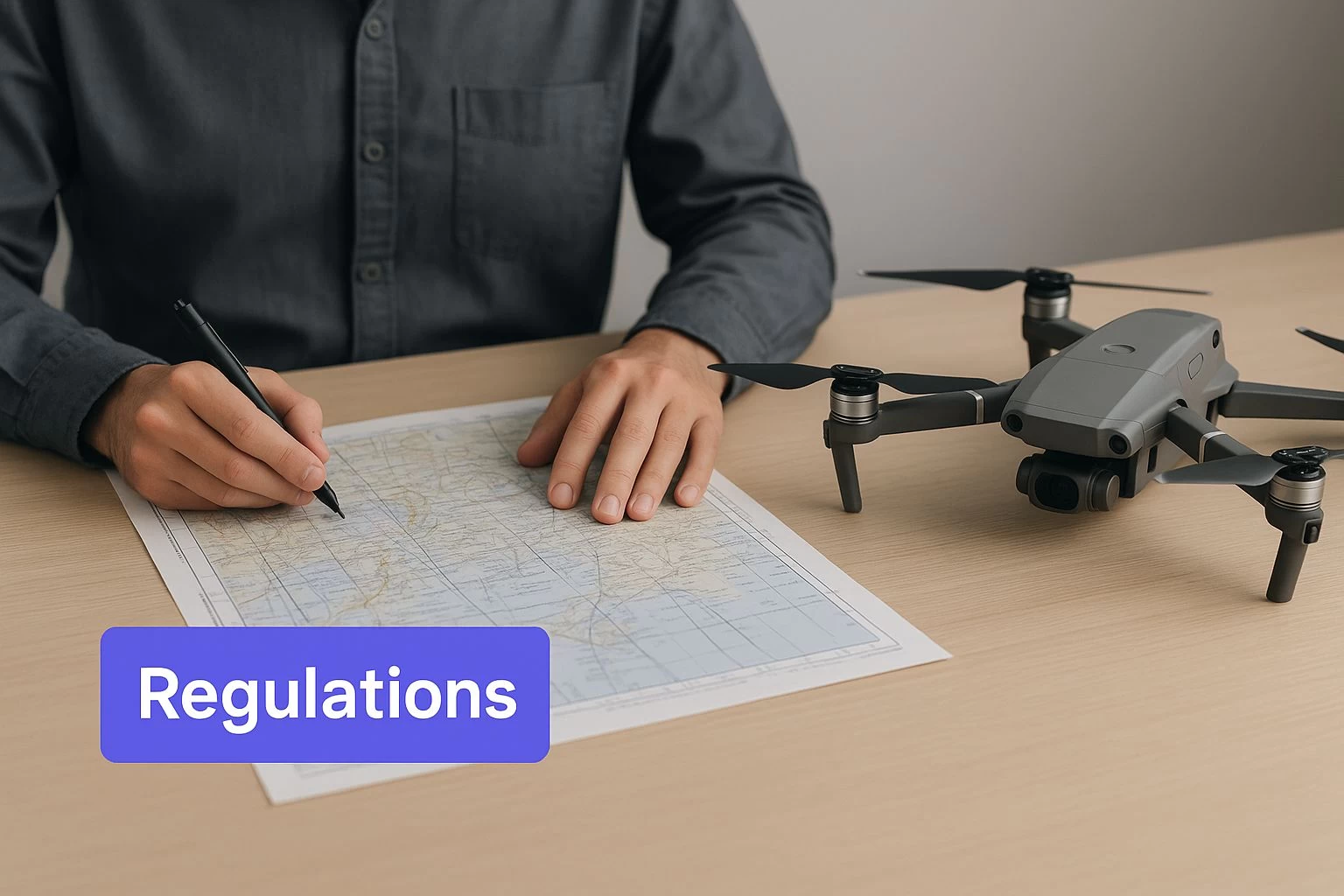
This image pretty much sums up a modern drone pilot's pre-flight routine: head down, deep in the maps, figuring out the airspace. At the end of the day, you're the one in charge, and it's your job to understand the rules of the sky to keep everyone safe.
I've found the best way to think about the different airspace classes is to picture them as zones in a city, each with its own traffic rules. To fly your drone safely, you need to know which part of town you're in. Let's walk through the FAA's classifications, starting with the most restrictive and working our way out to the wide-open spaces.
Class B Airspace: The Downtown Core
Imagine the bustling, chaotic downtown of a major city—that's Class B airspace. It surrounds the nation's biggest international airports, and it's the most controlled airspace out there. Its entire purpose is to protect massive passenger jets as they take off and land.
Flying a drone here is a big deal and heavily restricted. You absolutely must get explicit permission from Air Traffic Control (ATC) before your props even think about spinning up. For most of us, that means using the Low Altitude Authorization and Notification Capability (LAANC) system. Without that green light, Class B is a strict no-fly zone.
Class C Airspace: The Busy Suburbs
If Class B is the downtown core, think of Class C as the busy commercial suburbs ringing it. This airspace usually surrounds airports that see a lot of traffic—think regional hubs with control towers and a steady stream of flights—but aren't quite on the scale of a JFK or LAX.
Just like downtown, you need ATC authorization to fly here. LAANC is your go-to tool for getting that permission. The main takeaway is simple: if there’s a control tower, you need to ask for clearance before you fly.
Class D Airspace: The Small Town Center
Continuing the analogy, Class D is like the center of a smaller town. It typically surrounds local airports that have a control tower but handle less traffic than Class C airports. These are often the homes of regional airlines or a healthy amount of general aviation traffic.
The rule doesn't change. A control tower is a control tower, which means you need authorization. Once again, LAANC is the system you'll use to request access. Never make the mistake of thinking a smaller airport means relaxed rules; if a tower is running, you need permission.
Key Insight: The common thread for Class B, C, and D airspace is the airport control tower. If you see one, you need authorization. It really is that simple. This is a bedrock rule for safely managing airspace for drones.
Class E Airspace: The Connecting Highways
Class E is a bit of an oddball. It's still controlled airspace, but it's different. Think of it as the network of major highways connecting all the different city zones. It exists in places where ATC needs to manage air traffic, but there isn't a control tower on the ground.
For drone pilots, Class E can be tricky. In most cases, you can fly up to 400 feet without needing to ask for permission. The catch is when Class E airspace extends all the way down to the ground around an airport that doesn't have a tower. In those specific spots, you do need to request authorization. Your flight planning app is your best friend here—always double-check.
Class G Airspace: The Open Countryside
Finally, we get to Class G, or uncontrolled airspace. This is the open countryside, the rural areas, and the neighbourhoods far from any airport. It’s where most of us do our recreational flying and a good chunk of commercial work, too.
In Class G, you generally don't need ATC authorization as long as you stay at or below 400 feet above ground level (AGL). While it feels like more freedom, all the other rules still apply. You've got to keep your drone within your visual line of sight and avoid flying over people. Also, remember that some places, like national parks or military bases, are off-limits regardless of airspace class. It's always smart to check for other restrictions, which you can learn more about in our guide to drone restricted airspace.
Comparing Global Drone Regulations and Standards
While the core ideas of flying safely are pretty much the same everywhere, the actual rulebook for airspace for drones can change dramatically the moment you cross a border. A perfectly legal flight in Ohio could land you in hot water in Germany. That’s why any pilot with ambitions beyond their backyard needs a solid grasp of the global picture.
In the United States, the Federal Aviation Administration (FAA) calls the shots, mainly through its Part 107 rules for commercial pilots. It’s a well-oiled system centred on pilot certification, registering any drone over 250 grams, and sticking to clear operational rules like always keeping the drone in your line of sight (VLOS).
Over in Europe, the European Union has been working hard to create one single, harmonised market for drone flights. The goal is to get rid of the patchwork of different rules from country to country, making it much simpler for pilots to operate across the continent.
The EASA Framework in Europe
The European Union Aviation Safety Agency (EASA) has rolled out a framework that’s all about risk. It sorts drone flights into three buckets: 'Open,' 'Specific,' and 'Certified'. This is a smart shift because it moves the focus away from why you're flying (recreational vs. commercial) to how risky the flight actually is.
-
Open Category: This is for your low-risk stuff. It's broken down further by drone weight and how close you'll be to people. The big rules here are generally no flying over crowds and keeping your drone where you can see it.
-
Specific & Certified Categories: When the stakes are higher—like flying beyond visual line of sight (BVLOS) or transporting hazardous materials—you fall into these categories. This requires a thorough risk assessment and a green light from the national aviation authority.
This unified system makes life easier across dozens of countries. If you're looking for a deeper dive on this, our guide on what new drone regulations mean for UK and EU operators has all the details you need to stay compliant.
A Look at Regulations in Asia-Pacific
The Asia-Pacific region is a completely different beast. The regulatory scene there is a mixed bag, with rules changing quickly to keep up with a massive boom in drone technology. Each country seems to be carving its own path.
China, for example, now requires real-name registration for all drones and has mapped out strict no-fly zones, especially around airports and government buildings. This push for tighter control ramped up after a major incident in 2017 when drones caused chaos at Chengdu's airport. India has taken a tech-heavy approach with its 'No Permission, No Takeoff' (NPNT) system, which digitally locks down drones unless they have clearance.
Meanwhile, places like Japan and Australia have their own distinct flavour of rules. Japan, for instance, generally caps flights at 150 meters high, while Australia requires a Remote Pilot License for almost all commercial work.
The big lesson for any pilot flying internationally? Never assume. Every country sets its drone rules based on its own unique priorities, whether that’s national security or economic growth.
At the end of the day, these global differences highlight one crucial fact for every pilot. Before you even think about launching in a new country, you have to do your homework. What’s considered safe and legal use of airspace for drones is decided locally, and the duty to know and obey those rules is 100% on you. Pleading ignorance won't get you out of trouble.
The Future of Airspace and UTM Systems
As more and more drones take to the skies for everything from package delivery to critical infrastructure inspections, it’s clear our old ways of managing airspace just won’t keep up. The future of airspace for drones is going to be intelligent, automated, and deeply interconnected—a concept being brought to life by Unmanned Aircraft System Traffic Management, or UTM.
So, what is UTM? Think of it as a digital, dynamic air traffic control system built from the ground up for the low-altitude world where drones fly. We're not talking about controllers radioing pilots. Instead, imagine a sophisticated network where drones and their operators digitally file flight plans, share their locations in real-time, and automatically negotiate their paths to steer clear of each other.
Introducing a Smarter Sky
The whole point of UTM is to create a cooperative system where drones can safely fly in crowded skies without needing a human to micromanage every single flight. This is the very backbone that will support the complex drone operations we're all looking forward to, like fleets of autonomous delivery drones buzzing around a busy city.
Its European cousin, U-Space, shares the same fundamental vision. Both systems are built on a collection of digital services that manage drone traffic, feeding pilots crucial information on everything from weather hazards to other aircraft nearby. It’s all about creating a transparent and predictable environment for everyone involved.
Key Technologies Building the Future
This vision of a futuristic sky isn't just science fiction; it's being built right now, piece by piece, on the foundation of several key technologies. Each one plays a critical role in making the drone ecosystem safe, integrated, and secure.
- Remote ID: This is basically a digital license plate for your drone. It broadcasts essential identification and location data, letting authorities and other airspace users know who is flying where.
- Geofencing: Picture this as an invisible, digital fence. It sets up virtual boundaries around sensitive spots like airports, prisons, or power plants, automatically stopping drones from flying into restricted zones.
- 5G Connectivity: For all this to work, you need ultra-reliable, high-speed communication. 5G networks provide that super-low-latency connection drones need to instantly share data, get commands, and maintain constant awareness of their surroundings.
Together, these technologies are the building blocks of UTM. They supply the data, connectivity, and safeguards needed to manage a sky full of autonomous aircraft. Of course, a solid grasp of existing airspace classes is still fundamental, since these new systems build on top of what's already there. If you need a refresher, check out our guide on the key FAA airspace classifications explained.
The explosive growth of the global drone market is what’s really pushing the development of these advanced traffic management systems. With forecasts predicting the industry could hit over $160 billion by 2030, robust UTM and U-Space systems aren't just a nice idea—they're an absolute necessity. This change is happening worldwide, with countries piloting special urban zones for autonomous drone flights, all supported by advanced registration and geofencing. You can learn more about how these developments are shaping the global drone market outlook on ts2.tech.
When you get right down to it, UTM is the next logical step in the evolution of airspace for drones. It marks a major shift from static rules and manual approvals to a dynamic, data-driven system—one that can safely and efficiently support the next wave of aerial innovation.
Right, so you understand the theory behind drone airspace. But knowing the difference between Class B and Class G on paper is one thing; putting it into practice out in the field is where safety really gets put to the test.
A solid, repeatable pre-flight check isn’t just a nice-to-have. It’s a core professional responsibility. Think of this checklist as your pre-launch ritual, the kind that separates the pros from the amateurs. Just like an airline pilot, you need a thorough procedure before every single takeoff. Cutting corners here introduces risks you just don’t need to take, and the legal or financial blowback can be serious.
Step 1: Verify Your Flight Location and Airspace
Before you even think about packing your gear, the very first thing you need to do is a digital deep-dive on your proposed flight area. The days of showing up and hoping for the best are long gone. You absolutely need a reliable flight planning app to get the real story on the airspace you're heading into.
Fire up an FAA-approved app like B4UFLY or a more comprehensive flight management platform like Dronedesk. These tools give you an immediate, clear picture of the sky above your site. You'll instantly see:
- Airspace Class: Is it controlled (Class B, C, D, or E) and going to require authorization, or is it the wild west of Class G?
- Altitude Grids: Don’t just assume you have 400 feet to play with. Many areas, especially near airports, have much lower ceilings shown on the map.
- Surrounding Airports: Take note of any nearby airports, heliports, or even private grass strips. They all matter.
This initial digital recon is the bedrock of your entire flight plan. It tells you right away what rules apply and what hoops you might need to jump through.
Step 2: Check for Temporary Flight Restrictions
This one is critical. Before every single flight, you have to check for Temporary Flight Restrictions (TFRs). These are no-fly zones that can appear with very little warning for all sorts of reasons, and they are not optional.
A TFR is a non-negotiable, hard stop. Blundering into one, even by accident, is a serious violation that gets the attention of the FAA and law enforcement incredibly fast.
What could trigger a TFR?
- Major sporting events (think NFL or MLB games)
- VIP movements (like when the President is in town)
- Emergency scenes (wildfires, major accidents)
- Airshows and other special aviation events
Always, always check the FAA's official TFR list or, even better, use your flight planning app which should overlay active TFRs right on your map. Make this a non-negotiable part of your pre-flight routine—check the day before, and then check again right before you launch.
Step 3: Confirm Remote ID and Weather Conditions
Once you’ve got your airspace intelligence sorted, it’s time to look at your gear and the environment. First up: Remote ID. Make sure your drone's "digital license plate" is active and broadcasting properly. This is a regulatory must-have for almost all drones now, so don't skip it.
Next, get serious about the weather. This isn't just about glancing outside to see if it’s sunny. You need to look at the factors that directly mess with a drone:
- Wind Speed and Gusts: Are they safely within your aircraft's limits? Gusts are often what catch people out.
- Precipitation: Any rain, snow, or even dense fog can kill your drone and, just as importantly, ruin your ability to see it.
- Visibility: You have to be able to maintain a clear visual line of sight. Period.
- Temperature: Extreme cold absolutely hammers battery life, sometimes cutting your flight time in half.
Ignoring the weather is one of the top reasons drones crash. If conditions aren't right, be professional enough to scrub the mission and fly another day.
Step 4: Obtain LAANC Authorization if Needed
So, what if your checks in Step 1 showed you’re in controlled airspace like Class B, C, D, or E that extends to the surface? You're going to need authorization. The Low Altitude Authorization and Notification Capability (LAANC) system is your fastest path to getting it.
Let's walk through a real-world example. Say you've got a real estate shoot for a house just two miles from a small regional airport, smack in the middle of Class D airspace.
- You open your LAANC-enabled app.
- You draw your flight boundary around the property, setting your max altitude—say, 200 feet.
- The app instantly shows that you're within a pre-approved 200-foot altitude grid for automated authorization.
- You hit submit, and within seconds, you get an automated approval from the FAA to fly at or below 200 feet in that zone.
This system takes what used to be a painful, weeks-long paperwork process and turns it into a few taps on a screen. It makes flying compliantly near airports totally achievable. Just make sure you get that LAANC approval before you head out to the site.
Right, let's get into how Dronedesk takes the headache out of airspace compliance.
How Dronedesk Cuts Through the Airspace Compliance Hassle
Let's be honest, juggling airspace rules, surprise Temporary Flight Restrictions (TFRs), risk assessments, and flight logs can feel like a full-time job in itself. The old way of doing things—bouncing between multiple apps and websites before every single flight—isn't just a massive time sink. It's a recipe for something to slip through the cracks.
This is where a proper drone operations platform completely changes the game. It takes that tangled mess of a pre-flight checklist and turns it into one smooth, straightforward process.
Instead of trying to patch together information from all over the place, a platform like Dronedesk pulls all your essential pre-flight intelligence into a single, easy-to-digest mission dashboard. This isn't about just saving a few minutes; it's about eliminating the guesswork and automating the repetitive compliance checks that every professional pilot has to nail, every time. You get the full operational picture in seconds, not hours.
Automated Airspace Intelligence at Your Fingertips
The real magic is having instant access to clear, actionable airspace data layered right on top of your mission map. No more trying to decipher complex VFR charts or cross-referencing three different apps to see if you're clear to fly. You get one unified view of everything that could impact your mission.
For instance, Dronedesk’s built-in tools automatically flag:
- Controlled Airspace Zones: You'll see Class B, C, D, and E boundaries laid out clearly, so you know instantly if you need to get authorisation.
- Active TFRs: Any temporary flight restrictions are overlaid directly onto your flight plan. No more accidental no-fly zone incursions.
- Ground Hazards: It will pinpoint potential risks on the ground near your site, like schools, hospitals, or critical infrastructure that you need to be aware of.
Think of it like a digital co-pilot. By automating these crucial checks, you slash the risk of an oversight that could lead to a safety incident or a fine you really don't want to pay. It ensures you’ve considered all the critical airspace for drones before your boots even hit the ground.
Building a Rock-Solid Audit Trail
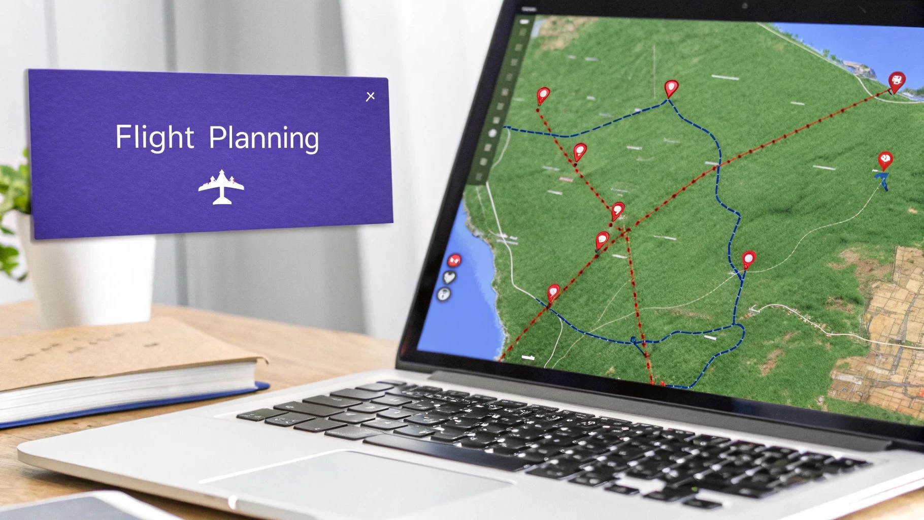
But just seeing the data isn't enough. A truly comprehensive platform helps you do something with it. Dronedesk weaves this airspace intelligence directly into your flight planning and risk assessment documents.
When you go to generate a risk assessment, the system automatically pulls in the known airspace and ground hazards for that location. Then, it prompts you to create specific mitigation strategies for them.
The image below shows you exactly how this airspace data is baked right into the flight planning interface.
This seamless process creates a complete, compliant audit trail for every single job. Your flight plans, risk assessments, and airspace checks are all logged, time-stamped, and stored, proving you've done your due diligence. It's not just about ticking regulatory boxes; it's about having bulletproof documentation for clients and insurers, showing with just a few clicks that you're a professional who runs a tight, safe operation.
Common Questions About Airspace for Drones
Even with the basics down, a few tricky questions always seem to pop up when we talk about airspace. Let's tackle some of the most common ones I hear from pilots. Getting these right will give you a huge boost in confidence and help keep every mission compliant.
Do I Need Authorization for Every Flight?
Nope, you don't. But—and this is a big but—you absolutely need to check the airspace before every single flight.
Authorization is really only for when you’re flying in controlled airspace that goes all the way down to the ground, like Class B, C, or D, and some specific Class E zones. If you’re in the clear, wide-open Class G airspace and staying below 400 feet, you generally don’t need to bother ATC.
The catch is, you have to know for sure which airspace you're in. That’s why using a flight planning app to verify your location before you lift off isn't just a good idea; it's a non-negotiable step for any responsible pilot.
What Is the Difference Between Altitude and Elevation?
This is a classic. It trips up so many new pilots, but getting it right is critical for steering clear of manned aircraft and other obstacles.
- Altitude (MSL): This is your height Above Mean Sea Level. Think of it as your height above the ocean. Manned aircraft live and breathe by MSL.
- Elevation (AGL): This is your height Above Ground Level—the actual ground directly under your drone. The drone rules, like the famous 400-foot ceiling, are all based on AGL.
Picture this: you take off from a 1,000-foot hill and fly 400 feet straight up. Your AGL is a perfectly legal 400 feet. But your MSL is now 1,400 feet, which is right where planes might be. Always, always plan your flights based on AGL.
It’s a common mistake to confuse your drone’s altitude limit with the ground’s elevation. The 400-foot rule applies to the height above the ground you are flying over, not just from where you took off.
How Do I Handle Pop-Up Flight Restrictions?
Ah, the dreaded TFR, or Temporary Flight Restriction. These are the bane of a poorly planned flight day. They can appear with almost no warning for things like emergencies, big sporting events, or VIP visits. Flying into one is a massive deal, and not in a good way.
Your only real defense here is being diligent. You must use an app with up-to-the-minute TFR data and check it right before you launch. There’s simply no excuse for not knowing about an active TFR in your area. This last-minute check is a cornerstone of managing airspace for drones and flying safely.
Ready to take the complexity out of your pre-flight checks? Dronedesk integrates real-time airspace intelligence, TFR alerts, and risk assessments into a single, seamless workflow. Streamline your operations and fly with total confidence by visiting https://dronedesk.io to see how it works.
 Drone VLOS Rules Explained for Commercial Teams →
 FAA Remote ID Rule Explained for Commercial Pilots →
 Drone Legal Requirements for Commercial Operations →
 Drone Near Airport Rules Explained for Safer Planning →
 International Drone Regulations Every Global Team Should Know →
 Drone Flight Risk Assessment Example for Safer Missions →
 Beyond Visual Line of Sight Explained for Operators →
 How BVLOS Drone Operations Change Commercial Workflows →
 FAA Drone Rules Every Commercial Pilot Should Know →
 FAA 107 Explained for Commercial Drone Operators →