Top 10 UAV Employment Opportunities to Explore in 2026
The unmanned aerial vehicle (UAV) industry is no longer a niche market; it is a rapidly expanding frontier of innovation with diverse and rewarding career paths. As drone technology integrates into every major sector, from construction and agriculture to public safety and entertainment, the demand for skilled professionals has skyrocketed. Finding the right role requires understanding the specific needs of these industries and the skills they value most.
This guide provides a detailed roundup of the top 10 UAV employment opportunities available today. We move beyond generic job titles to explore specific roles, the required skills and certifications, and typical salary expectations. Our focus is on providing actionable insights to help you launch or advance your career.
You will learn about positions ranging from the hands-on Commercial Drone Pilot to the data-focused Drone Data Analyst. We will cover specialized roles like Thermal Imaging Specialist and strategic positions such as Drone Fleet Manager. For each opportunity, we will detail:
- Core responsibilities and day-to-day tasks.
- Essential certifications, like the FAA Part 107.
- Industry-specific tools and software, including operations management platforms for flight logging and compliance.
- Practical tips for building a strong portfolio and finding job listings.
Whether you're an aspiring pilot, a data guru, or an entrepreneur planning a drone service business, this article delivers the specific information needed to turn a passion for drones into a profession. We'll show you how to find your place in this growing field and give you a competitive edge from day one.
1. Commercial Drone Pilot (Part 107 Certified)
The Commercial Drone Pilot is often the first role that comes to mind when considering UAV employment opportunities, and for good reason. This is the foundational career path where a certified individual operates drones for compensation. To fly legally for business purposes in the United States, you must obtain an FAA Remote Pilot Certificate, commonly known as a Part 107 license. This certification confirms your understanding of airspace regulations, weather effects, and safe operational procedures.
A Part 107 pilot's work is incredibly diverse. You might find yourself capturing stunning aerial photos for a high-end real estate listing one day and conducting a detailed roof inspection for an insurance claim the next. The role demands both technical piloting skill and a keen eye for the specific data or imagery a client needs.
Common Applications and Industries
- Real Estate & Architecture: Creating compelling property marketing videos and photos or documenting construction progress from start to finish.
- Infrastructure & Utilities: Performing routine safety inspections on power lines, wind turbines, bridges, and cell towers, often in hard-to-reach locations.
- Agriculture: Using multispectral sensors to assess crop health, monitor irrigation, and calculate plant counts for precision farming.
- Media & Events: Capturing dynamic aerial footage for films, commercials, news broadcasts, or live events like concerts and weddings.
Tips for Success
To stand out in a competitive field, it’s not enough to simply get certified. Specializing in a high-demand niche like thermal inspections or LiDAR mapping can significantly increase your earning potential. Before accepting client work, secure professional liability insurance to protect your business. Building proficiency with one or two specific drone models is more effective initially than trying to master an entire fleet. As you prepare for the certification exam, understanding the associated expenses is crucial; you can find a detailed breakdown of the drone license cost to budget accordingly. Maintaining meticulous records of every flight, including pre-flight checks and maintenance, is non-negotiable for compliance and professionalism.
2. Drone Data Analyst
While the pilot captures the data, the Drone Data Analyst is the professional who gives it meaning. This critical role in the world of UAV employment opportunities involves processing, interpreting, and visualizing the vast amounts of information collected by drones. An analyst transforms raw sensor outputs-like thermal readings, multispectral imagery, or point cloud data-into actionable intelligence that drives business decisions. This is where terabytes of data become clear, concise reports that solve specific problems.
This position bridges the gap between field operations and strategic outcomes. A data analyst doesn't just look at pictures; they use specialized software to measure volumes, detect anomalies, and track changes over time. They are the storytellers who translate complex aerial data into a language that project managers, farmers, and engineers can understand and act upon, making them an indispensable part of a modern drone operation.

Common Applications and Industries
- Agriculture: Analyzing multispectral imagery to create crop health maps for precision fertilizer application, saving farmers money and boosting yields.
- Construction & Mining: Performing volumetric analysis of stockpiles to track materials, calculate earthwork progress, and ensure project accuracy.
- Energy & Utilities: Inspecting solar farms with thermal cameras to identify underperforming or damaged panels for targeted maintenance.
- Environmental Monitoring: Using high-resolution orthomosaics to track deforestation, monitor coastal erosion, or assess the impact of natural disasters.
Tips for Success
To excel as a Drone Data Analyst, deep expertise in specific software is essential. Master complementary tools like ArcGIS for geospatial analysis, Pix4D for photogrammetry, and DroneDeploy for processing and visualization. Specializing in a particular vertical, such as thermal analysis for energy or volumetric calculations for construction, allows you to differentiate your services and command higher rates. Create a strong portfolio showcasing successful projects with quantified business impact, like "identified 50 faulty solar panels, saving the client an estimated $20,000 in lost production." A solid understanding of data management is also key; learning more about how to set up a drone data management program can provide a structured approach to handling client information. Finally, stay current with the application of AI and machine learning, which are increasingly used to automate and refine the data analysis process.
3. Drone Service Provider / Aerial Surveying Specialist
Beyond basic photography, one of the most technical and valuable UAV employment opportunities lies in aerial surveying and mapping. A Drone Service Provider (DSP) or Aerial Surveying Specialist uses advanced drone technology, such as photogrammetry and LiDAR, to capture high-precision spatial data. This information is then processed to create detailed 3D models, orthomosaic maps, and digital elevation models for clients in engineering, construction, and environmental management.
This role transforms the drone from a camera into a sophisticated measurement tool. Specialists in this field provide clients with actionable data that supports critical decisions, such as site planning, resource management, and safety compliance. Success depends on a deep understanding of geospatial principles, data processing software, and the ability to guarantee survey-grade accuracy.
Common Applications and Industries
- Construction & Engineering: Creating topographic surveys for bid planning, monitoring earthwork volumes, and conducting as-built verification against design plans.
- Mining & Aggregates: Performing volumetric calculations of stockpiles, monitoring pit progression, and ensuring site safety and environmental compliance.
- Land Surveying: Augmenting traditional ground-based methods to cover large or inaccessible areas quickly, reducing field time and project costs.
- Environmental Management: Tracking coastal erosion, monitoring land use changes, and assessing the impact of natural disasters with high-resolution data.
- Utilities: Conducting detailed surveys of transmission line corridors to identify vegetation encroachment and potential structural integrity issues.
Tips for Success
To build a reputable surveying business, investing in survey-grade equipment from manufacturers like DJI Enterprise or Trimble is a must to ensure data accuracy and client acceptance. You can also create powerful partnerships by offering your aerial services to traditional surveying firms, expanding your client base and credibility simultaneously. Develop detailed case studies that clearly show the cost and time savings your drone-based methods offer compared to conventional ground surveys. Finally, to scale your business, it’s critical to use a robust operations management platform to track projects, manage client deliverables, and maintain flight and maintenance logs for your entire fleet.
4. Drone Fleet Manager / Safety and Compliance Officer
As organizations scale their drone programs from a single aircraft to a full fleet, a specialized leadership role becomes essential. This is where the Drone Fleet Manager or Safety and Compliance Officer steps in, representing one of the more advanced uav employment opportunities. This position moves beyond piloting and focuses on the strategic oversight of multi-aircraft operations, managing everything from pilot teams and maintenance schedules to regulatory adherence and operational safety.
These professionals are the central nervous system of a large-scale drone program. Their responsibility is to ensure that every mission is conducted safely, efficiently, and in full compliance with FAA regulations and internal company policies. They coordinate complex airspace authorizations, develop safety protocols, investigate incidents, and manage the entire lifecycle of the drone fleet, from procurement to retirement.
Common Applications and Industries
- Enterprise Operations: Managing fleets for national infrastructure companies conducting widespread inspections of power grids, pipelines, or rail lines.
- Construction & Development: Coordinating drone teams across multiple large-scale jobsites to monitor progress, conduct surveys, and ensure site safety.
- Government & Environmental Agencies: Overseeing drone programs for environmental monitoring, wildlife tracking, or public safety surveillance.
- Logistics & Delivery: Companies like Amazon Prime Air rely on safety and compliance officers to develop and enforce the rigorous protocols necessary for autonomous delivery networks.
- Insurance & Claims: Managing a fleet of drones and pilots deployed nationally to assess property damage after catastrophic events.
Tips for Success
Success in this role requires a blend of regulatory knowledge, technical expertise, and strong leadership. Developing standardized operating procedures (SOPs) is critical for ensuring every pilot on your team performs consistently and safely. Establish a robust maintenance tracking system for your aircraft to maximize their operational lifespan and prevent unexpected downtime. To centralize all these moving parts, you can learn more about drone fleet management platforms that integrate flight planning, pilot scheduling, and compliance reporting. Building relationships with regional FAA offices and other airspace stakeholders will also be invaluable for navigating complex operational requests. Finally, create detailed dashboards that track key performance indicators like flight hours, mission success rates, and safety incidents to demonstrate the program’s value and identify areas for improvement.
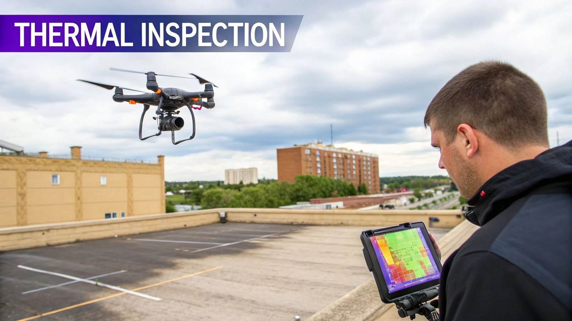
5. Thermal Imaging and Inspection Specialist
Beyond standard visual data, one of the most valuable UAV employment opportunities involves interpreting the invisible world of heat. A Thermal Imaging and Inspection Specialist operates drones equipped with infrared cameras to detect temperature variations on surfaces. This role translates thermal data into actionable insights, identifying problems like energy loss, electrical faults, or moisture intrusion that are invisible to the naked eye.
The work is less about piloting and more about data analysis, requiring a deep understanding of thermography principles to diagnose issues correctly. You might be hired by a commercial real estate firm to conduct a building energy audit, identifying HVAC inefficiencies, or by a utility company to find overheating components on transformers before they fail. It’s a specialized field that commands high value by enabling predictive and preventive maintenance.
Common Applications and Industries
- Building & Roofing: Identifying insulation failures, air leaks, and moisture intrusion under roof membranes for commercial and residential properties.
- Electrical & Utilities: Inspecting substations, power lines, and transformers for hotspots that indicate imminent component failure.
- Solar Farms: Detecting defective, underperforming, or damaged panels in large-scale solar arrays quickly and efficiently.
- Manufacturing & Industrial: Monitoring the temperature of critical machinery and equipment to implement predictive maintenance schedules and prevent costly downtime.
Tips for Success
Success in this niche requires more than just an advanced drone. Obtain a Level I or Level II Thermography certification from an accredited organization like the Infrared Training Center (ITC) to build credibility and master data interpretation. Partner with facilities management companies, energy auditors, and engineering firms to establish a steady stream of client work. Investing in a high-quality thermal camera system from an established manufacturer is critical for accurate data. To stay organized, use specialized software to develop standardized report templates, ensuring your clients receive consistent and professional deliverables for every inspection.
6. Agricultural Drone Specialist / Precision Ag Consultant
The role of an Agricultural Drone Specialist merges advanced UAV technology with agronomy, creating a powerful career path within precision agriculture. These specialists use drones equipped with multispectral or hyperspectral sensors to provide farmers with data-driven insights that were previously unavailable. Instead of just capturing visual imagery, this job involves analyzing vegetation indices like NDVI to monitor crop health, detect irrigation issues, and identify pest infestations before they become widespread.
This position is much more than a pilot; it’s a consultant who translates complex aerial data into actionable agronomic advice. A farmer might hire a specialist to determine where to apply fertilizer with variable-rate precision or to identify areas of water stress in a vineyard. This one of the key uav employment opportunities that directly impacts food production, resource efficiency, and farm profitability.
Common Applications and Industries
- Row Crop Farming: Assisting corn and soybean operations with variable-rate nitrogen application plans based on crop vigor analysis.
- Viticulture (Vineyards): Monitoring for signs of disease like Pierce's Disease and managing precision irrigation to improve grape quality and yield.
- Large-Scale Production: Identifying early-stage pest infestations in massive cotton fields, allowing for targeted spraying instead of blanket application.
- Specialty Crops: Tracking water stress and development in high-value almond or pistachio orchards to optimize irrigation and harvest timing.
- Organic Farming: Supporting integrated pest management by pinpointing problem areas for targeted, non-chemical interventions.
Tips for Success
Success in this field requires more than just piloting skills; it demands a solid foundation in agricultural science. Consider obtaining specialized training in precision agriculture and agronomic principles from universities like Penn State or Texas A&M to build credibility. Partnering with local agricultural extension services and established agronomic consultants is a great way to build a client base and demonstrate your value. Tools like Dronedesk can help manage seasonal client contracts and schedule flights to align with critical crop growth stages. To provide genuine value, focus on developing agronomic expertise beyond simple drone operation, positioning yourself as a holistic advisor. Finally, create compelling case studies that clearly show yield increases and cost savings from your analysis, as this tangible proof of ROI is your most effective marketing tool.
7. Real Estate and Architectural Drone Photographer
One of the most visually compelling and in-demand UAV employment opportunities is in real estate and architectural drone photography. This specialized role involves capturing high-quality aerial imagery and videography to market properties and visualize architectural projects. Professionals in this field combine expert piloting with a strong artistic sense to showcase buildings, landscapes, and developments from perspectives that ground-level photography simply cannot achieve.
For real estate agents, compelling visuals are critical for attracting buyers, and a drone's unique vantage point can highlight a property's best features, its size, and its relationship to the surrounding neighborhood. Similarly, architects and developers use aerial shots to create realistic visualizations of proposed designs, document construction progress, and market large-scale projects. This career path is perfect for those who have a passion for both technology and creative expression.
Common Applications and Industries
- Luxury Real Estate: Creating exclusive marketing campaigns for high-end residential homes, showcasing expansive estates and unique property features.
- Commercial Properties: Marketing office buildings, retail centers, and industrial parks for sale or lease to business clients.
- Architectural Visualization: Assisting architectural firms by providing aerial context for 3D models and visualizing how new structures will fit into the existing environment.
- Hospitality & Resorts: Producing promotional content for hotels, golf courses, and vacation properties that highlights amenities and scenic landscapes.
- New Development Marketing: Documenting and marketing large residential communities, showcasing amenities like pools, parks, and walking trails.
Tips for Success
To excel, investing in high-quality imaging drones like the DJI Mavic 3 series is essential for delivering professional-grade photos and videos. Building a strong portfolio with diverse property types is crucial for attracting clients; be sure to include examples of both residential homes and commercial buildings. Actively build relationships with real estate agents, brokers, and property management companies to generate consistent work. Tools like Dronedesk can help you manage client projects, track deliverable dates, and keep your business organized. Finally, master post-production editing software to color grade footage, add music, and create polished final products that set your work apart.
8. Drone Infrastructure and Utility Inspector
Drone Infrastructure and Utility Inspectors play a critical role in maintaining the safety and reliability of essential services like power, telecommunications, and transport. This specialized UAV employment opportunity involves using drones to conduct detailed visual and thermal inspections of critical assets, identifying damage, wear, and potential failures before they cause outages or accidents. This work significantly reduces risk by replacing dangerous manual inspections that often require rope access, bucket trucks, or helicopters.
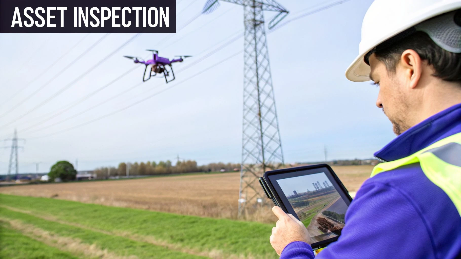
This role is data-driven, demanding a methodical approach to capturing high-resolution imagery and sensor readings. An inspector’s primary job is to provide asset managers and engineers with actionable intelligence, allowing them to make informed maintenance decisions, prioritize repairs, and ensure regulatory compliance. It’s a field where precision and reliability are paramount.
Common Applications and Industries
- Energy & Utilities: Power utility companies use drones to inspect transmission lines for faulty insulators, while wind farm operators monitor turbine blades for cracks and erosion.
- Telecommunications: Telecom firms examine cell tower structural integrity, antenna alignment, and component condition without requiring tower climbs.
- Oil & Gas: Pipeline operators conduct corridor inspections to detect leaks, encroachment, and right-of-way issues across vast, often remote territories.
- Transportation & Civil Engineering: Government agencies and engineering firms assess the structural condition of bridges, dams, and roadways, identifying concrete spalling or rebar corrosion.
Tips for Success
Beyond a Part 107 certificate, specialized credentials like an OSHA 10 or 30 certification are often required to even step on a job site. Investing in rugged, reliable equipment with high-resolution and thermal cameras is essential for this work. Partnering with established engineering firms or utility contractors can provide a steady stream of projects. You must also develop expertise in both visual and thermal imaging to deliver comprehensive inspection reports. Using a platform to create standardized inspection checklists and reporting protocols will ensure consistent, high-quality deliverables for every client. Meticulous flight planning and record-keeping are non-negotiable for compliance and proving the value of your service.
9. Drone Software Developer / Flight Control Engineer
While pilots operate drones, software developers and flight control engineers are the architects behind their capabilities. This advanced career path involves designing the core systems that govern a drone's behavior, from stable flight and autonomous navigation to sophisticated data processing. These professionals write the code that makes a UAV more than just a remote-controlled aircraft, turning it into a smart, data-gathering tool.
This role is one of the most technical and rewarding UAV employment opportunities, sitting at the intersection of robotics, computer science, and aerospace engineering. A developer might create algorithms for a drone to autonomously inspect a wind turbine, build mission-planning software for complex survey routes, or develop the flight control systems that allow for precise, stable hovering in difficult conditions. The work directly advances what drones can achieve in the field.
Common Applications and Industries
- Drone Manufacturing: Developing proprietary flight control software, obstacle avoidance systems, and user interfaces, as seen with companies like Skydio and DJI.
- Open-Source Platforms: Contributing to community-driven autopilot projects like ArduPilot or PX4, which power a wide range of custom and commercial drones.
- Enterprise Software: Creating specialized applications for enterprise clients, such as custom data processing pipelines or integrations with existing business intelligence platforms.
- Payload and System Integration: Writing the software that allows specialized sensors, like LiDAR or thermal cameras, to communicate with the drone's flight controller and ground station, a focus for firms like Flyby Technology.
Tips for Success
Success in this field hinges on a strong technical foundation and a demonstrable portfolio. Contribute to open-source drone projects like ArduPilot or QGroundControl to build credibility and real-world experience. You should also network with drone manufacturers and software platforms to identify unlisted career opportunities and gain industry exposure through internships. Given the prevalence of Python in drone programming, preparing for Python Developer Interview Questions is a highly recommended step. Specializing in a high-demand area such as computer vision for autonomous flight or AI/ML for predictive data analysis can set you apart and lead to more significant roles.
10. Drone Training Instructor and Consultant
As the drone industry matures, the demand for high-quality education creates significant UAV employment opportunities for seasoned experts. Drone Training Instructors and Consultants are experienced pilots who educate aspiring professionals, develop safety programs, and advise organizations on how to best integrate drones into their workflows. This role moves beyond flying missions to shaping the next generation of pilots and influencing enterprise-level drone programs.
These professionals are essential for building a competent and safe drone workforce. They might lead hands-on flight training for a UAS flight school, design a custom curriculum for a corporation’s internal inspection team, or consult with a university to launch an accredited drone program. This career path requires a deep well of operational experience combined with strong communication and teaching skills.
Common Applications and Industries
- UAS Flight Training Centers: Working for established schools like the National Academy of Drones or Drone Pilot Ground School to deliver Part 107 prep and advanced flight instruction.
- Corporate and Enterprise Training: Developing and delivering specialized training programs for large companies in sectors like energy, construction, or insurance to upskill their internal teams.
- Academic Institutions: Teaching at universities or community colleges that offer drone technology degrees or certificate programs.
- Government & Public Safety: Training pilots within military, law enforcement, and fire departments on specific mission sets like surveillance, search and rescue, and incident mapping.
Tips for Success
Becoming a respected instructor requires more than just a Part 107 license. Aim to build extensive operational experience, with at least 100 logged flight hours as a bare minimum, before you begin teaching others. Obtaining advanced certifications in areas like thermography or complex airspace operations will distinguish you as a true subject matter expert. When creating course material, develop an engaging, interactive curriculum that uses real-world case studies to demonstrate concepts. To expand your reach beyond a local market, consider creating online or hybrid training options. You can also build partnerships with flight schools, corporations, and academic institutions to secure consistent work. Finally, stay current with evolving FAA regulations and immediately incorporate those changes into your curriculum to ensure your students receive the most accurate information.
10 UAV Career Comparison
| Role | 🔄 Implementation Complexity | ⚡ Resources & Cost | 📊 Expected Outcomes | 💡 Ideal Use Cases | ⭐ Key Advantages |
|---|---|---|---|---|---|
| Commercial Drone Pilot (Part 107 Certified) | Moderate — Part 107, VLOS, flight planning and compliance | Moderate — consumer/prosumer drone, insurance, ongoing training | Aerial photos, maps, inspections; steady freelance or contract income | Real estate, site monitoring, basic inspections, mapping | High demand, quick certification path, flexible work |
| Drone Data Analyst | High — GIS, orthomosaics, ML and data pipelines | Moderate — powerful workstation, software licenses, specialized training | Actionable analytics, detailed reports, decision-support products | Precision ag analysis, construction volumetrics, environmental monitoring | Remote work, premium rates, less weather-dependent |
| Drone Service Provider / Aerial Surveying Specialist | High — survey-grade workflows, QA, coordinate systems | High — LiDAR/multispectral sensors, computing cluster, certifications | Survey-grade deliverables, high-value contracts, recurring projects | Construction surveys, mining, government mapping, utilities | Premium pricing, scalable business model, technical credibility |
| Drone Fleet Manager / Safety & Compliance Officer | Very high — multi-team ops, waivers, SOPs, incident management | High — fleet management software, staff, maintenance budgets | Efficient, compliant large-scale operations; reduced incidents, KPI visibility | Enterprise inspection programs, multi-site construction, delivery fleets | Leadership impact, high compensation, shapes safety standards |
| Thermal Imaging & Inspection Specialist | Moderate–High — thermography principles, calibration, reporting | High — thermal cameras ($20k–50k+), thermography certification | Detailed thermal reports for maintenance and energy savings; premium hourly rates | Building audits, electrical inspections, solar panel surveys, roofs | Specialized demand, year-round opportunities, high margins |
| Agricultural Drone Specialist / Precision Ag Consultant | High — multispectral analytics, NDVI, agronomy knowledge | High — multispectral/hyperspectral sensors ($30k–100k+), software, seasonal ops | Yield optimization, input savings, farm-specific prescriptions | Large row crops, vineyards, specialty crops, irrigation management | Growing market, measurable ROI for clients, seasonal recurring work |
| Real Estate & Architectural Drone Photographer | Moderate — advanced composition, post-production, client management | Moderate — high-quality cameras, editing software, portfolio costs | High-impact marketing assets, improved listings, visual portfolios | Luxury real estate, commercial properties, architectural visualization | Creative output, steady demand, premium pricing for quality work |
| Drone Infrastructure & Utility Inspector | High — strict safety protocols, asset-specific inspection standards | High — high-res and thermal sensors, insurance, utility certifications | Safety-critical inspection reports, recurring contracts, liability reduction | Power lines, towers, pipelines, bridges, wind farms | Stable demand, high pay, essential safety function |
| Drone Software Developer / Flight Control Engineer | Very high — control systems, autonomy, hardware–software integration | Moderate–High — development tools, test hardware, R&D investment, advanced degrees | Scalable autonomous systems, platform integrations, competitive IP | Autonomy development, enterprise platforms, avionics vendors | Top earning potential, innovation-focused, broad industry impact |
| Drone Training Instructor & Consultant | Moderate–High — curriculum design, adult learning, regulatory updates | Low–Moderate — training materials, simulators, extensive operational experience | Certified pilots, improved safety culture, revenue from courses and consulting | Flight schools, corporate programs, government and industry training | Flexible/scaleable work, influence on standards, diversified income streams |
Launching Your Drone Career: Next Steps and Strategic Tools
The sky is no longer the limit; it's the new frontier for a diverse and growing workforce. The UAV employment opportunities we've explored, from the hands-on expertise of a Thermal Imaging Specialist to the strategic oversight of a Drone Fleet Manager, illustrate a dynamic and expanding industry. Your journey from enthusiast to professional doesn't follow a single flight path. Instead, it’s about identifying a niche that aligns with your skills and committing to the continuous learning required to excel. The common thread connecting every successful drone professional is not just piloting skill, but a foundation built on safety, compliance, and operational excellence.
To truly stand out, you must move beyond simply completing flights. The most sought-after professionals are those who can manage the entire project lifecycle with precision. This includes everything from initial client consultation and risk assessment to delivering polished data products and maintaining meticulous records. This end-to-end management capability is what separates a hobbyist from a high-value service provider.
Key Takeaway: The most valuable UAV professionals are not just pilots; they are business operators who manage data, clients, and compliance with equal proficiency. Your ability to integrate these elements will directly influence your earning potential and career growth.
Charting Your Course: Actionable Next Steps
Translating your ambition into a career requires a structured approach. Here are the immediate, actionable steps you should take to build momentum and secure one of the many available UAV employment opportunities:
-
Specialize and Certify: General piloting is the baseline. Choose a specialty like agricultural analysis, infrastructure inspection, or cinematic videography. Then, pursue advanced certifications (e.g., ITC Level 1 Thermography, survey-specific training) to validate your expertise and command higher rates.
-
Build Your Digital Footprint: A professional portfolio is non-negotiable. Use flight logging platforms to document your hours and mission types. Curate your best work on a dedicated website or social media profile that showcases your specialty. This digital proof of performance is your most powerful marketing tool.
-
Master Your Professional Narrative: Your resume and cover letter must speak the language of the drone industry. Highlight specific aircraft you've operated, sensors you've used (LiDAR, thermal), and software you've mastered (Pix4D, DroneDeploy). To effectively showcase your skills and experience in the UAV industry, mastering the art of Crafting Your Perfect Resume is a crucial next step. Tailor your application to demonstrate how your unique skills solve the specific problems of the employer or client.
-
Adopt an Operations Management System: Before you get overwhelmed with administrative tasks, implement a drone operations platform. Managing flight plans, maintenance logs, client details, and compliance paperwork manually is inefficient and prone to error. Centralizing these tasks from day one establishes a professional, scalable foundation for your business or career progression within an enterprise. This proactive step demonstrates a serious commitment to operational integrity.
The drone industry is built on trust, which is earned through consistent, documented, and safe operations. By taking these strategic steps, you are not just preparing for a job; you are building a reputable brand and a sustainable career. The future of UAV employment opportunities belongs to those who combine technical skill with business acumen. Your next flight is not just a job, it's a building block for your future in this exciting field.
Ready to elevate your drone operations from a hobby to a professional business? Dronedesk is the all-in-one platform designed to manage your clients, plan your flights, and handle your compliance paperwork, freeing you to focus on growth. Start your free trial of Dronedesk today and build the professional foundation your drone career deserves.
 Drone Flight Risk Assessment Example for Safer Missions →
 Beyond Visual Line of Sight Explained for Operators →
 How BVLOS Drone Operations Change Commercial Workflows →
 FAA Drone Rules Every Commercial Pilot Should Know →
 FAA 107 Explained for Commercial Drone Operators →
 Canadian Drone Regulations Explained for Business Use →
 FAA Part 107 Drone License Explained for Beginners →
 How to Review a DJI Drone Flight Log Step by Step →
 Drone Registration Law Explained for Commercial Pilots →
 How to Check a Drone NOTAM Before Every Mission →