GCV Explained in UK SORA and BVLOS Planning
Ask most UK drone operators what slows down a BVLOS application and the answer is rarely the aircraft alone. It is the evidence: where the aircraft will fly, what happens if it does not behave as expected, who is exposed on the ground, and how the operator can prove those assumptions are controlled.
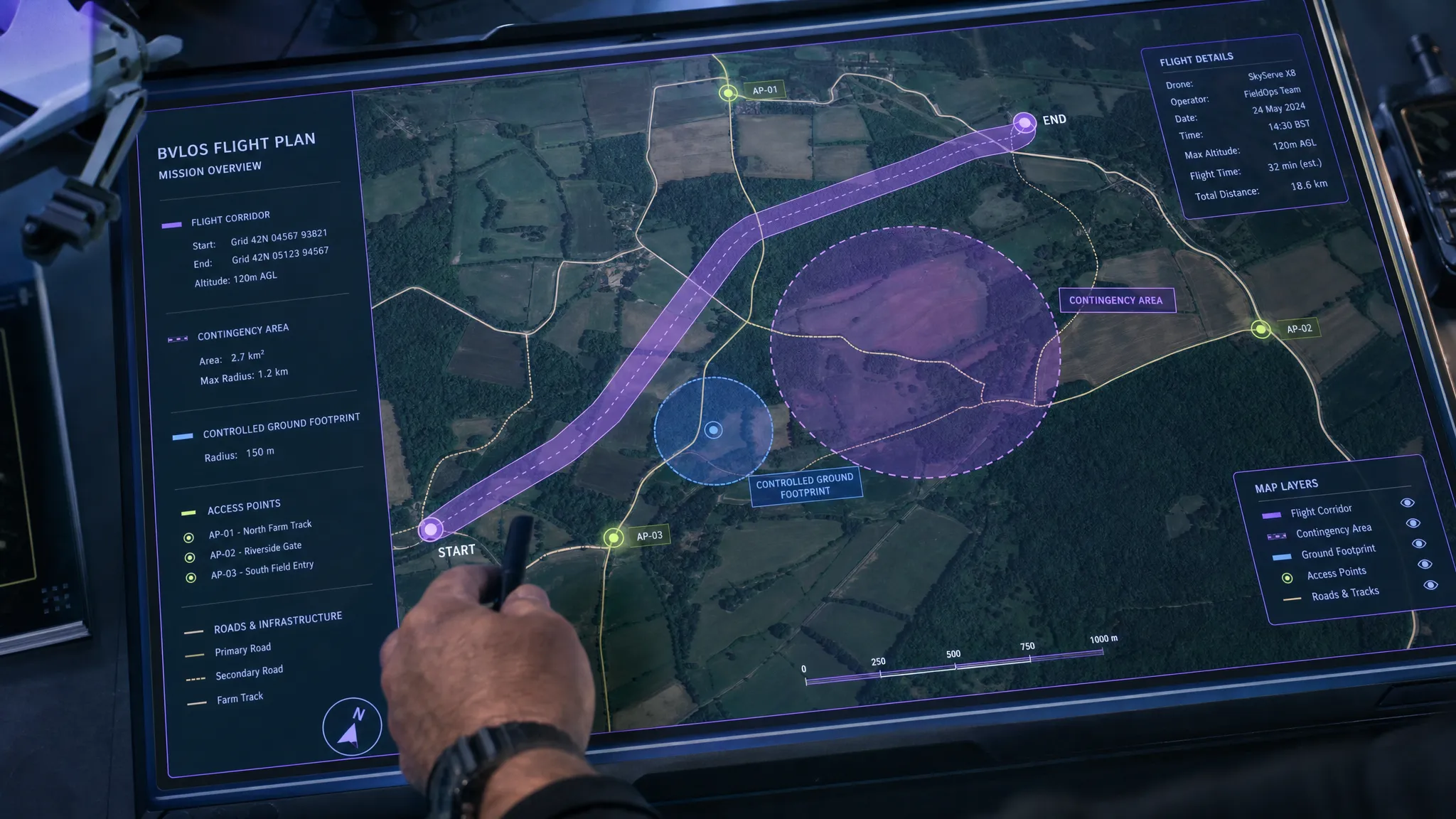
That is where GCV becomes important. In UK SORA and BVLOS planning, GCV is commonly used to mean Ground Controlled Volume: a defined three-dimensional volume whose ground footprint is controlled well enough for the operator to justify the ground-risk assumptions in the safety case.
A good GCV is not just a polygon on a map. It is a defensible planning concept that links land access, population exposure, contingency space, containment, emergency procedures and operational discipline. For survey companies, utility inspection teams and emergency services, understanding this concept can make the difference between a safety case that feels theoretical and one that is practical, auditable and ready for scrutiny.
What does GCV mean in UK SORA?
A Ground Controlled Volume is best understood as the volume of operation that sits above a controlled ground footprint. The key point is control. The operator must be able to show that the people and property beneath the planned operation are managed in a way that matches the risk assumptions being made.
In UK SORA work, GCV is not a magic shortcut or a single standalone approval category. It sits alongside established SORA concepts such as flight geography, contingency volume, ground risk buffer, controlled ground area, ground risk class and operational volume. If you are submitting an application, always use the exact terminology requested by the UK CAA or your competent adviser. In day-to-day planning discussions, however, GCV is a useful shorthand for the controlled ground-risk volume you intend to rely on.
It is also worth clearing up a common confusion: GCV is not GVC. The GVC, or General VLOS Certificate, is a UK remote pilot competency often used for VLOS operations in the Specific category. GCV, in this article, refers to the Ground Controlled Volume concept used in operational risk planning.
Why GCV matters for BVLOS operations
BVLOS, or Beyond Visual Line of Sight, normally places an operation in the Specific category because the remote pilot is not maintaining direct unaided visual contact with the aircraft. The UK Civil Aviation Authority explains the Specific category as the route for operations that present greater risk than the Open category and require an operational authorisation. The CAA’s Specific category guidance is the starting point for understanding that framework.
SORA, the Specific Operations Risk Assessment methodology developed by JARUS and adopted in different forms by regulators, separates the problem into ground risk and air risk. The JARUS SORA publications provide the underlying methodology, while the UK CAA’s CAP 722A publication is the key UK reference for Specific category operational risk assessment.
GCV primarily helps with the ground-risk side of the argument. It helps answer questions such as:
- Where exactly could the UA be during normal, abnormal and emergency phases?
- Who could be beneath it?
- Can the operator keep uninvolved people out of the relevant ground area?
- What happens if the aircraft exits the intended flight path?
- Are the buffers and contingency actions credible for the aircraft, weather and crew?
For BVLOS, this matters because the operation may cover longer distances, linear corridors, remote infrastructure, variable terrain or dynamic incident scenes. The ground environment can change quickly. A public footpath, lay-by, farm track, road crossing, railway boundary, car park or event site can undermine a GCV if it is not identified and controlled.
GCV versus related SORA terms
A frequent mistake is treating GCV as if it replaces official SORA terminology. It does not. It is better to use GCV as a practical planning lens that pulls several SORA elements together.
| Term | Plain-English meaning | Why it matters |
|---|---|---|
| GCV, Ground Controlled Volume | A defined volume above a ground footprint the operator can control or justify | Helps structure the ground-risk argument for BVLOS and complex operations |
| Controlled ground area | A surface area where the operator can ensure only involved persons are present | Supports lower population exposure assumptions when genuinely controlled |
| Flight geography | The area or route where the aircraft is intended to fly during normal operation | Forms the core of the planned operation in the ConOps |
| Contingency volume | Additional volume used if the aircraft enters an abnormal state but remains recoverable | Gives space for return, hold, terminate, land or other contingency procedures |
| Ground risk buffer | Additional ground area considered to protect people if control is lost or containment fails | Links aircraft performance, altitude, speed, wind and failure modes to ground exposure |
| Operational volume | The combined normal and contingency operating volume | Sets the boundary for containment and monitoring assumptions |
The important distinction is that ground control is not the same as airspace control. A GCV may show that you can manage people on the surface, but it does not remove the need to assess air risk, other airspace users, detect-and-avoid arrangements, command-and-control performance, emergency coordination and any required airspace permissions.
How to define a GCV for BVLOS planning
A defensible GCV starts with the mission, not with the map. The map is the output of operational thinking, not a substitute for it.
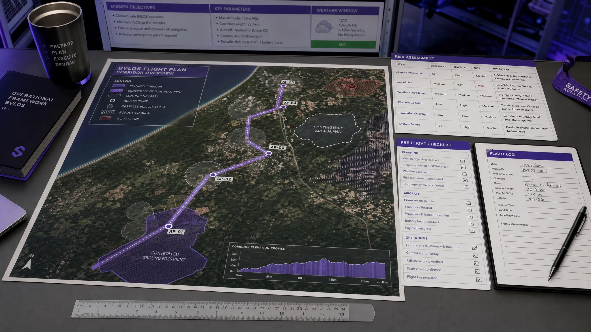
Start with the ConOps
Your Concept of Operations should describe the task, aircraft, payload, crew, operating area, altitude, route, flight phases, communications, decision points and emergency arrangements. For a utility inspection, the ConOps may be a linear corridor along pylons, pipelines, rail assets or water infrastructure. For a survey company, it may be a defined rural site, construction boundary or quarry. For emergency services, it may be a dynamic search area linked to incident command.
The GCV should then reflect how that operation actually works. A narrow corridor may be appropriate for a slow, contained inspection with strong access control. A wider area may be needed where the aircraft is faster, higher, operating in stronger winds, or using automated turns, holds or return routes.
Prove ground control, do not just assert it
Private land is not automatically controlled. A field may have a public right of way. A construction site may have subcontractors moving unpredictably. A rural track may be used by dog walkers, riders or farm vehicles. A utility corridor may cross roads, gardens, commercial premises or land owned by third parties.
For SORA purposes, the question is practical: can you ensure that uninvolved persons are not exposed in the way your safety case assumes? Evidence may include landowner permissions, site induction processes, barriers, marshals, access logs, road or path closures, incident cordons, timed operations, stakeholder briefings and clear stop/go criteria.
Size the volume around credible failure cases
A GCV should include more than the planned flight line. It needs to consider what the aircraft could do before a contingency action takes effect. That may include navigation error, GNSS degradation, command link issues, fly-away scenarios, wind drift, return-to-home behaviour, braking distance, turn radius, descent profile, parachute deployment, termination logic and crew reaction time.
There is no universal GCV width that is correct for every BVLOS operation. The right answer depends on the aircraft, operating height, kinetic energy, speed, environmental conditions, containment system, crew procedures and the surrounding ground environment.
Treat edges as risk hotspots
The boundary of a GCV is usually where weak assumptions show up. If the aircraft is operating near a road, railway, public path, school, housing edge, event site or industrial facility, your plan needs to explain how that edge is managed. The same applies where a rural corridor crosses a village, car park, campsite, marina or popular viewpoint.
In many BVLOS plans, the safest approach is segmentation. Instead of trying to justify one large GCV for an entire route, divide the operation into sections with different controls. A remote section may rely on land access control and low population density. A road crossing may require a temporary hold point, observer, marshal, closure or alternative route. A populated edge may require the flight geography to be moved or the operation to be conducted under different conditions.
Link the GCV to procedures
A GCV is only credible if the crew know what to do when conditions change. The planned volume should connect directly to checklists, briefings, communications and emergency response actions.
For example, your procedures should define when the operation is paused because an uninvolved person enters the area, who has authority to stop the flight, how the remote pilot is informed, what happens during lost link, what the aircraft will do at each geofence boundary, and how emergency services or site owners are contacted if needed.
Examples of GCV thinking in real operations
The shape and strength of a GCV varies by sector. The following examples are simplified, but they show how different operators should think about the same underlying problem.
| Operation type | GCV opportunity | Watch-out |
|---|---|---|
| Rural land survey | Defined site boundary, landowner permission and low public access may support a clear GCV | Public rights of way, neighbouring properties and seasonal events can change the risk |
| Utility corridor inspection | Linear infrastructure may allow a route-based GCV with planned access controls at crossings | Roads, footpaths, railway interfaces and third-party land can break continuous control |
| Construction or quarry survey | Site security, inductions and controlled work areas can provide strong evidence | Contractors, delivery drivers and visitors must be treated consistently in the procedures |
| Emergency services search | Incident cordons and command structures may help create a temporary controlled ground footprint | Dynamic public movement, media presence and responder safety need constant reassessment |
| Coastal or upland BVLOS task | Sparse population may reduce exposure along parts of the route | Car parks, trails, rescue access points and changing weather can quickly alter assumptions |
For emergency services, the GCV may be highly dynamic. A police, fire or search and rescue drone team might be operating within an incident cordon one moment and near public access points the next. The planning challenge is not simply drawing a larger area. It is making sure incident command, ground teams and the remote pilot share the same understanding of where the aircraft can operate and when the task must be paused or replanned.
What evidence should support a GCV?
A reviewer should be able to follow your logic without relying on verbal explanation. That means your GCV evidence should be documented, version-controlled and connected to the wider SORA submission.
| Evidence area | What to include | Common weak point |
|---|---|---|
| Map pack | Flight geography, contingency volume, ground footprint, buffers, access points and sensitive receptors | A single map with no layers, scale, date or assumptions |
| Land and access control | Permissions, closures, marshals, site rules, cordons or stakeholder agreements | Assuming private land equals controlled land |
| Population exposure | Time of day, site use, rights of way, nearby roads, events and seasonal variation | Using generic rural assumptions where the site has public access |
| Aircraft and containment | Aircraft performance, geofencing, lost-link actions, termination logic and limitations | Describing features without linking them to the actual route and weather |
| Crew procedures | Stop/go criteria, communications, roles, briefings and emergency actions | Procedures that do not say who does what under pressure |
| Change management | Triggers for replanning, weather limits, route changes and post-flight review | Treating the GCV as fixed even when site conditions change |
Common GCV mistakes in UK SORA applications
The most common GCV problems are not technical. They are evidence problems. The aircraft may be suitable and the route may be sensible, but the documentation does not prove the assumptions.
Common mistakes include:
- Drawing a polygon without explaining how ground access is controlled.
- Ignoring public rights of way, informal paths, lay-bys, car parks and seasonal visitors.
- Using one GCV for a long BVLOS route even though the ground environment changes section by section.
- Treating GCV as a ground-risk solution while leaving air risk, detect-and-avoid or command link assumptions underdeveloped.
- Copying buffer distances from another aircraft or site without linking them to the actual UA, altitude, wind and failure modes.
- Failing to connect the GCV to checklists, briefings, logs and emergency response procedures.
A strong SORA pack should read like a chain of reasoning. The ConOps describes the mission. The maps show the operating volume and ground context. The risk assessment explains the hazards. The procedures show how the crew will maintain control. The logs prove the operation was conducted in line with the plan.
How Dronedesk supports the admin behind GCV planning
GCV work can quickly become fragmented if maps, checklists, risk assessments, crew details, client information and flight logs are managed in separate spreadsheets or folders. That fragmentation is a problem because SORA evidence depends on consistency.
Dronedesk is an all-in-one drone operations management platform with features for flight planning, airspace intelligence, proximity intelligence, configurable checklists, risk assessments, flight logging, fleet management, team management, client management and reporting. For teams preparing BVLOS or more complex Specific category work, that means the operational admin around a GCV can be kept closer to the job record rather than scattered across disconnected documents.
This does not replace the need for competent SORA preparation or regulatory approval. It does help operators build a more disciplined workflow around planning, documenting, reviewing and logging drone operations. If you are refining your wider risk process, Dronedesk’s guide on building a drone flight risk assessment that works is a useful companion read.
Practical checklist before relying on a GCV
Before using a GCV as part of a UK SORA or BVLOS planning argument, ask five simple questions.
First, can you define the ground footprint and operational volume clearly enough that another competent person can understand them from the documents alone? If not, your maps or ConOps need more detail.
Second, can you prove control of the ground area, not merely ownership or expectation of low use? If there is a public right of way, shared access route or uncontrolled boundary, your plan needs to address it.
Third, have you considered credible abnormal and emergency scenarios, not just normal flight? A GCV that only fits the ideal flight path is not enough.
Fourth, does the GCV connect to live operational decisions? Crew members need clear criteria for pausing, aborting, holding, landing or escalating.
Finally, have you separated ground risk from air risk? A strong GCV can support ground-risk mitigation, but BVLOS also requires a robust air-risk argument.
Frequently Asked Questions
Is GCV the same as GVC? No. GVC means General VLOS Certificate, a recognised UK remote pilot competency. GCV, in this article, means Ground Controlled Volume, a planning concept used when discussing controlled ground-risk volumes in SORA and BVLOS work.
Does a GCV make BVLOS approval easier? A well-evidenced GCV can make the ground-risk part of a BVLOS safety case clearer, but it does not guarantee approval. Air risk, command-and-control performance, detect-and-avoid arrangements, crew competence, aircraft reliability and emergency procedures still need to be addressed.
Can public land be part of a GCV? Potentially, but only if the operator can lawfully and practically control access in line with the safety case assumptions. If uninvolved persons can enter unpredictably, the area may not support the level of control being claimed.
How wide should a GCV be? There is no universal width. It depends on the aircraft, speed, altitude, containment, wind, failure modes, contingency procedures and the surrounding ground environment. The width must be justified for the specific operation.
Should a GCV include the ground risk buffer? The GCV should be planned with the ground risk buffer and contingency assumptions in mind. The exact way you present this should align with the terminology and structure expected in your UK SORA documentation.
Can software create a compliant GCV automatically? Software can help organise planning data, maps, checklists, risk assessments and logs, but it cannot replace competent operational judgement or regulatory review. The operator remains responsible for the safety case and the accuracy of the assumptions.
Bring structure to your BVLOS planning workflow
If your team is preparing more complex operations, the hard part is often keeping the evidence consistent from planning through to post-flight records. GCV thinking only works when the maps, risk assessment, crew procedures, checklists and logs tell the same story.
Dronedesk helps drone operators manage the operational admin around flight planning, risk assessments, checklists, airspace and proximity intelligence, fleet records, team details and flight logging in one place. Explore the Dronedesk features to see how a more connected workflow can support safer, better documented drone operations.
 GCV Explained in UK SORA and BVLOS Planning →
 British Drone Laws Explained for Commercial Operators →
 Commercial Drone Services: How to Scale Without Chaos →
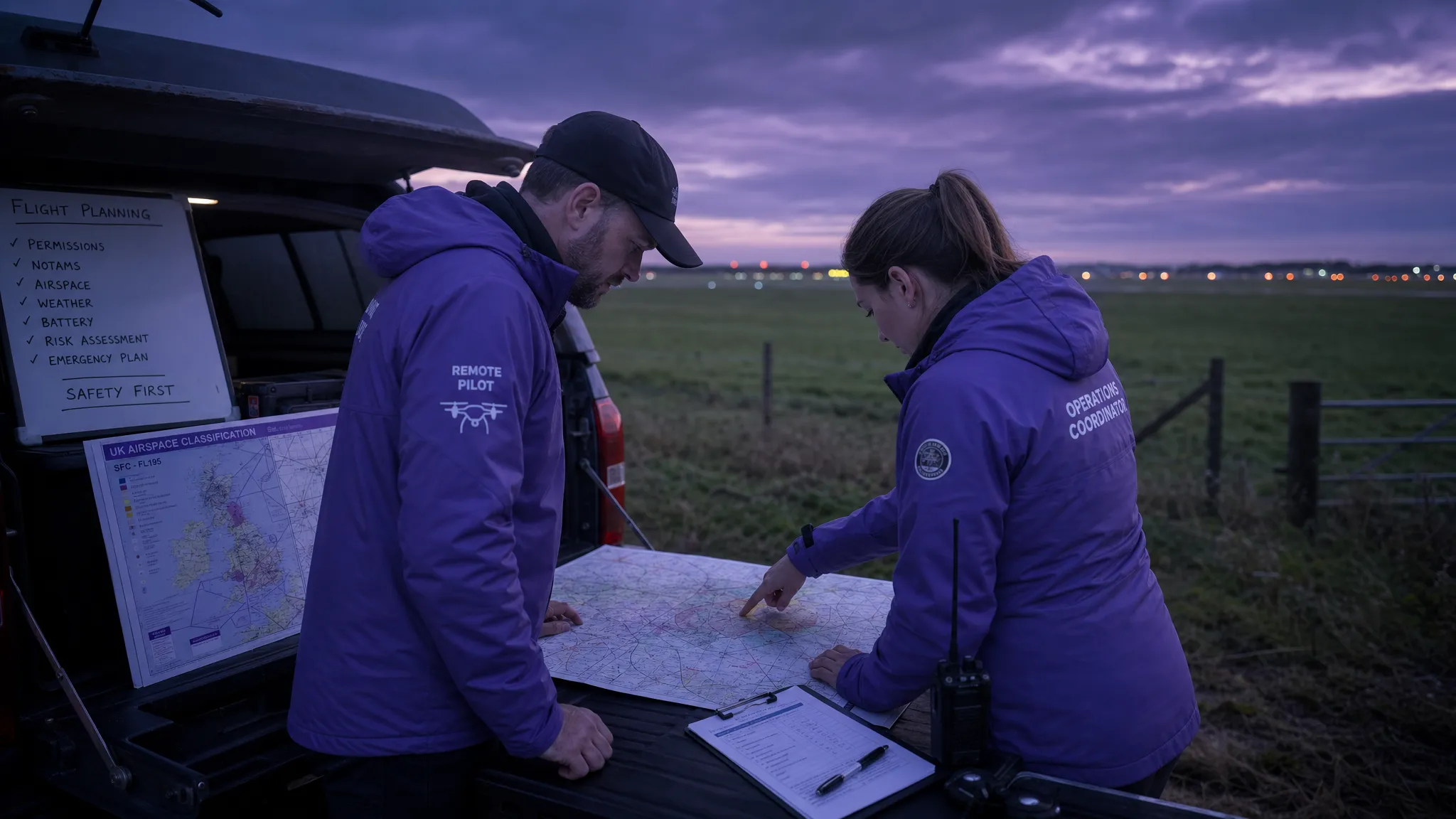 Drone Airspace Map Guide for Safer UK Flight Planning →
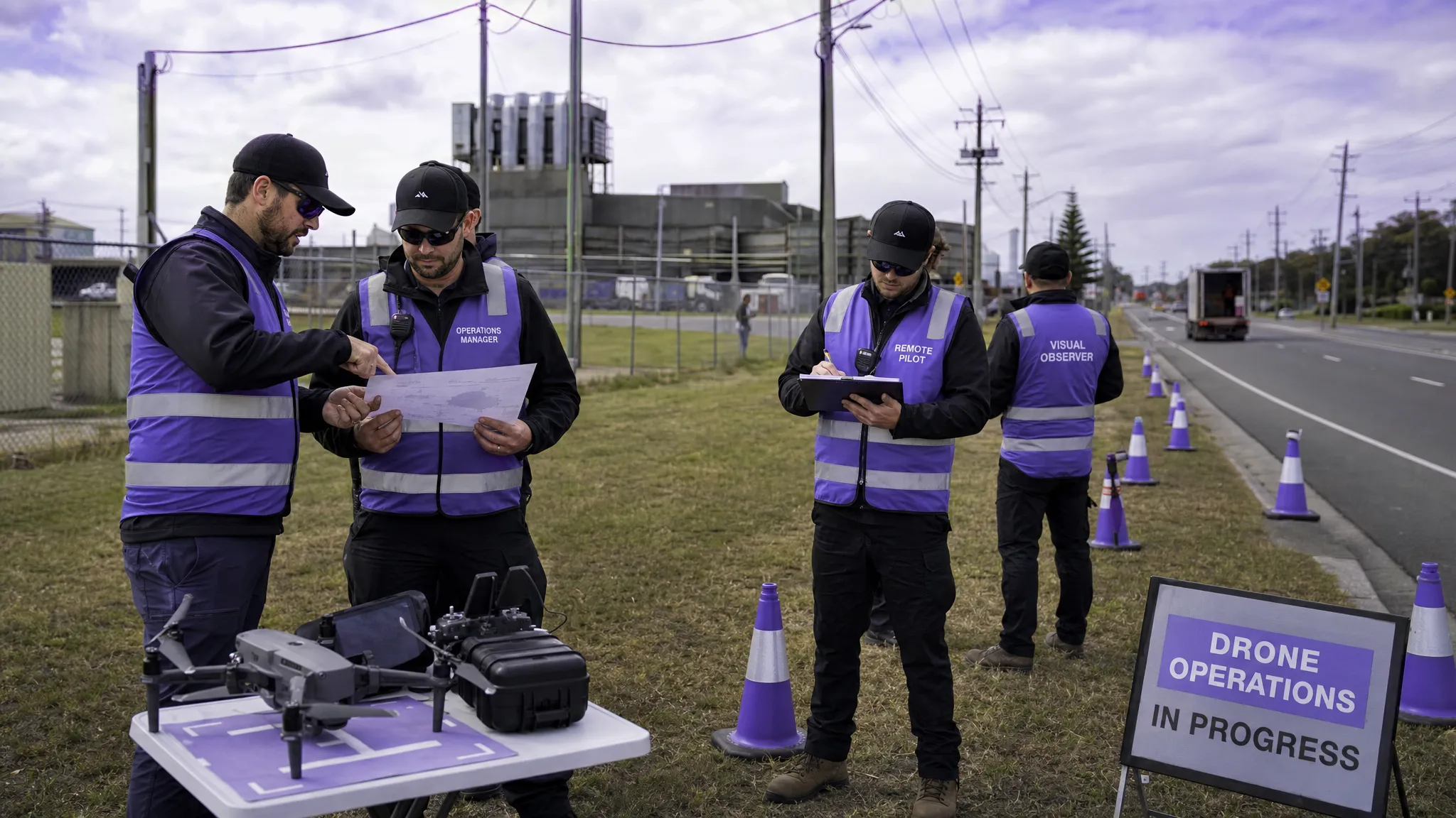 How to Build a Drone Flight Risk Assessment That Works →
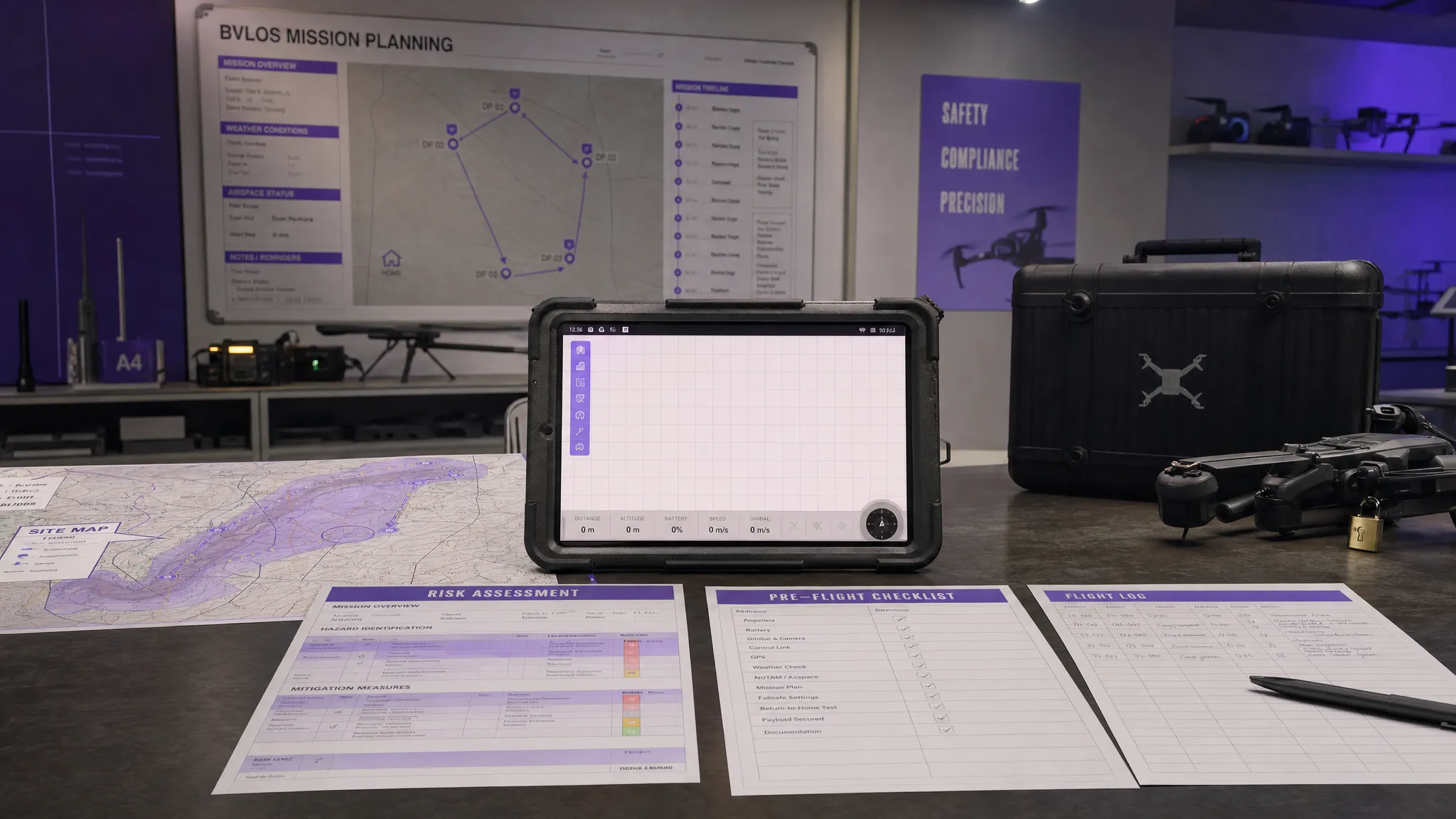 BVLOS Meaning Explained for Commercial Drone Teams →
 Drone Mapping Companies: How to Choose the Right Partner →
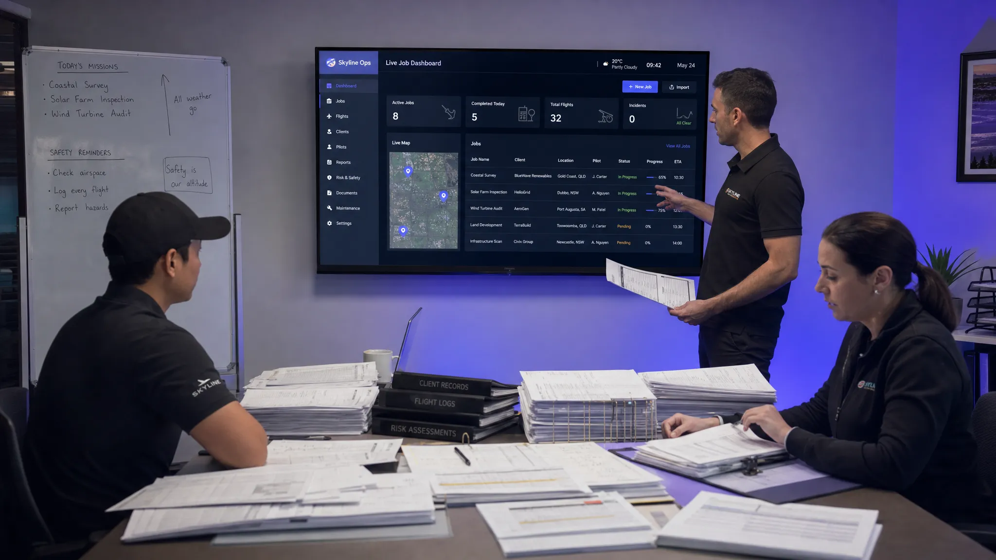 Why Drone Operations Management Software Beats Spreadsheets →
 How to Build a Drone Business Website That Wins Clients →
 Drone Safety Checklist for Commercial Flights →