
Drone Night Flying Rules and Pre-Flight Checks
Night operations can unlock work that is difficult or impossible in daylight: thermal roof inspections after heat loading, emergency scene awareness, security patrols, infrastructure checks with reduced public activity and creative filming with controlled lighting. The legal position is usually less dramatic than people expect, but the operational discipline needs to be much tighter.
If you are searching for drone night flying rules, the core question is not simply whether night flying is allowed. It is whether you can still meet the same legal duties you have in daylight, especially visual line of sight, airspace checks, separation from people, safe site control and reliable emergency procedures.
This guide focuses on UK operations, with practical notes for professional drone operators, survey companies, utility teams and emergency services. If you operate outside the UK, use the same planning logic but check the rules of your national aviation authority.
Are drone night flights legal in the UK?
Yes, drone flights at night are permitted in the UK when the operation complies with the relevant Civil Aviation Authority rules and any conditions in your operational authorisation, operations manual or client procedures.
Night does not create a separate permission route by itself. A flight that fits within the Open category in daylight may still fit within the Open category at night, provided you can meet all the same limits and safety duties. That includes staying within visual line of sight, observing the usual height limit, keeping the required distance from uninvolved people and respecting airspace restrictions.
For professional work, many night missions fall into more complex operational territory because of the location, proximity to people, critical infrastructure, emergency conditions or the need for repeatable procedures. If the job falls outside the Open category, it may require an Operational Authorisation in the Specific category. The night element should then be reflected in your risk assessment, procedures, crew roles and contingency planning.
The CAA Drone and Model Aircraft Code is the best starting point for UK operators because it sets out the everyday rules for flying safely and legally. For location planning, the CAA also publishes guidance on airspace restrictions, including Flight Restriction Zones around protected aerodromes.
| Rule area | What to confirm before a night flight |
|---|---|
| Operator and pilot compliance | Registration, Flyer ID where required, competency, insurance and any company approvals are current |
| Operating category | The mission fits the Open category or is covered by a valid Specific category authorisation |
| Visual line of sight | The remote pilot can see the aircraft directly, judge its orientation and monitor surrounding airspace |
| Height and separation | The planned flight respects the applicable height limit and distance from uninvolved people |
| Airspace | FRZs, controlled airspace, restricted areas, NOTAMs and temporary restrictions have been checked |
| Site permissions | Landowner, client, site security and local authority requirements have been addressed where relevant |
| Night controls | Lighting, crew briefings, emergency procedures and site marking are suitable for low-light conditions |
What counts as night for drone operations?
In practical terms, treat any low-light condition that affects your ability to see the drone, obstacles or surrounding airspace as a night operation. That includes dusk, dawn, foggy winter afternoons, unlit rural sites, brightly lit urban sites with glare and any job where the aircraft may blend into a dark background.
Legal definitions can matter, particularly if your operational authorisation, operations manual, client specification or regulator guidance refers to night, sunset, sunrise or civil twilight. Do not rely on an app screenshot alone. Check the definition used in your procedures and record the source of your sunset, sunrise or twilight times in the job file.
A conservative approach is better for commercial work: if the conditions require additional lighting, a revised crew briefing or a different emergency plan, document the job as a night or reduced-visibility operation even if part of the flight occurs around twilight.
Visual line of sight is the main night flying challenge
Most night drone incidents begin with a simple problem: the aircraft is technically airborne and controllable, but the pilot no longer has enough visual information to make safe decisions.
Visual line of sight is not the same as seeing the camera feed. It means the remote pilot can see the aircraft directly, without binoculars or a screen, well enough to control it safely, maintain awareness of its orientation and avoid other aircraft or obstacles. A thermal camera, spotlight, map display or telemetry readout can support the mission, but none of them replaces visual line of sight unless you are operating under a permission that explicitly allows otherwise.
At night, visual line of sight depends on more than distance. A drone may be easy to spot 250 metres away against a dark hillside but almost invisible 80 metres away against urban lighting. Orientation can also be misleading if all the pilot can see is one white light moving across the sky.
Useful controls include bright anti-collision lighting, orientation lighting that distinguishes front from rear, a defined maximum operating range for the conditions, a properly briefed observer and clear lost-sight actions. If you use a visual observer, define exactly what they are responsible for. They can improve situational awareness, but the remote pilot remains responsible for the flight.
UK operators should follow current CAA requirements and any authorisation conditions. If you also operate under EASA rules in Europe, note that EASA Open category night flights require a green flashing light on the unmanned aircraft. Do not assume lighting rules are identical across jurisdictions.
Planning the mission before you leave the office
Good night flights are usually won or lost before the vehicle is loaded. The planning phase should prove that the operation is legal, needed, proportionate and controllable in darkness.
Start by defining the purpose of the night flight. A thermal inspection, emergency overwatch or security patrol may have a clear operational reason. A routine daylight-capable survey may not justify the additional risk unless there is a client, safety or data-quality reason to fly at night.
Then review the operating category. Confirm whether the planned height, location, people proximity, airspace and aircraft class keep the mission inside the Open category or whether it needs Specific category authorisation. For professional teams, this should be linked to your operations manual and task risk assessment rather than treated as an informal decision on the day.
Airspace checks matter even more at night because detecting other aircraft visually can be harder. Review controlled airspace, aerodrome Flight Restriction Zones, temporary restrictions, danger areas, military activity and NOTAMs. If the work is near an airport, heliport or hospital helicopter route, build in extra time for coordination and permissions. Dronedesk has a separate guide on planning flights near airports without surprises if that is part of your operating environment.
For commercial operators managing multiple clients or aircraft, a central planning workflow reduces the chance that one person keeps critical information in a notebook or inbox. Dronedesk’s features page lists flight planning, airspace intelligence, proximity intelligence, configurable checklists, risk assessments, fleet management, team management and flight logging as part of its drone operations management platform.
Building a night-specific risk assessment
A standard daylight risk assessment is not enough for a night mission. The same location can behave differently after dark: public movement changes, security gates close, wildlife activity increases, wires become harder to see and the pilot’s depth perception is reduced.
If your risk assessment template only asks whether the weather is suitable and the take-off area is clear, it is too thin for serious night work. It should force the operator to consider darkness as a risk multiplier across airspace, people, obstacles, crew performance and emergency response. For a deeper structure, see Dronedesk’s guide to building a drone flight risk assessment that works.
| Night hazard | Why it matters | Practical control |
|---|---|---|
| Reduced obstacle visibility | Wires, branches, cranes and masts may be hard to identify | Daylight reconnaissance, obstacle mapping, conservative flight paths and higher clearance margins |
| Poor aircraft orientation | The pilot may see the drone but not know its heading | Directional lighting, shorter range limits, clear hover checks and observer support |
| Glare and light pollution | Streetlights, floodlights and vehicle headlights can hide the aircraft | Reposition the pilot, reduce operating range and avoid looking through glare sources |
| Public behaviour changes | People may gather at events, nightlife areas or emergency scenes | Cordon planning, ground crew, client liaison and revised take-off location |
| Fatigue | Night work often happens after a normal working day | Duty limits, rest planning, second pilot availability and stop-work triggers |
| Battery performance | Cold temperatures can reduce available performance | Warm storage, conservative reserve limits and battery health checks |
| Emergency access | Gates, barriers and site staff may not be available after hours | Confirm access, keys, contacts, lighting and recovery routes before deployment |
| Data limitations | RGB imagery may be noisy, blurred or unsuitable | Test exposures, use the right payload and confirm acceptance criteria with the client |
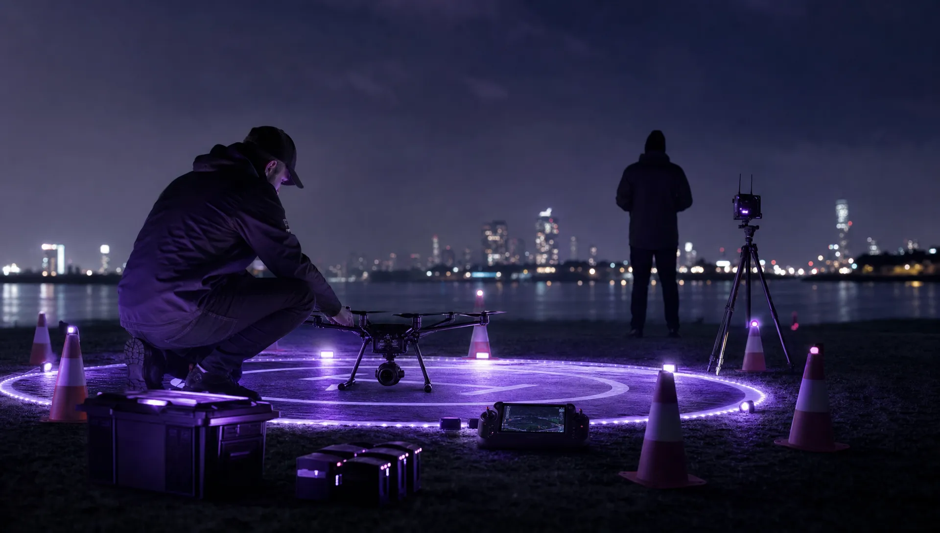
Night pre-flight checks on site
When you arrive on site, resist the pressure to launch quickly. Darkness makes it easier to miss a closed gate, temporary mast, overhead cable, parked vehicle or member of the public walking into the operating area.
Begin with a short site walk. Confirm the take-off and landing area, emergency landing options, crew positions, exclusion zone and any obstacles identified during planning. If the site was assessed using daylight imagery, check whether anything has changed. Temporary lighting towers, scaffolding, traffic management, cranes and event infrastructure are common surprises.
Your pre-flight checks should also include a deliberate lighting test. Check the aircraft lights from the pilot position and from the expected maximum range before launch, not after the drone is already halfway through the mission. Confirm that the lighting helps orientation rather than creating confusion.
| Check area | Night-specific items to verify |
|---|---|
| Aircraft | Propellers, arms, motors, payload mount, lenses, lights, strobes, firmware status and any known defects |
| Batteries | Charge level, temperature, cycle condition, secure fit, return reserve and cold-weather margin |
| Controller and display | Screen brightness, night mode, map visibility, telemetry readability, spare power and cable condition |
| Navigation | GNSS status, compass health, home point, return-to-home height and geofence alerts where applicable |
| Payload | Focus, exposure, thermal calibration, lens cleanliness, storage media and mission settings |
| Crew | Roles, call signs, lost-sight procedure, emergency words, observer scanning sectors and fatigue check |
| Site | Landing zone lighting, obstacle clearance, access route, public separation and emergency recovery areas |
| Weather | Wind at operating height, gusts, rain, fog, dew point, temperature and visibility trend |
For automated or repeatable missions, avoid assuming the daylight flight plan is still safe. Check waypoint altitudes, camera angles, orbit radii and return-to-home behaviour against the night hazard picture. A waypoint route that was acceptable in daylight may pass too close to unlit structures or terrain at night.
Weather and environmental checks after dark
Night weather can change quickly, particularly around temperature, fog, condensation and wind shear near buildings or hills. Do not rely only on a forecast taken hours earlier.
Visibility is the first concern. If mist, drizzle or low cloud reduces your ability to see the aircraft or detect other airspace users, the flight should be delayed or cancelled. A drone light that looks bright in clear air can disappear in fog or heavy rain.
Cold temperatures deserve a separate battery decision. Many aircraft provide battery temperature warnings, but a professional pre-flight process should not wait for an alert. Store batteries within manufacturer guidance, keep them warm before use and set a more conservative return threshold when conditions are cold.
Moisture can also affect data. Night inspections often involve cooler surfaces, dew and reflections from artificial lighting. For RGB imagery, review test images at full size before committing to a full survey. For thermal work, allow for payload stabilisation and confirm that the timing of the mission supports the thermal contrast you need.
Data quality checks for surveys, inspection and utilities
A safe night flight is not automatically a successful job. Survey and utility clients often need repeatable evidence, not just images captured in difficult conditions.
For mapping and photogrammetry, night flights can introduce blur, high ISO noise, poor feature matching and inconsistent lighting. If the deliverable depends on accurate reconstruction, verify whether night capture is suitable at all. Artificial lighting can create shadows and reflections that undermine processing quality.
For thermal inspections, night may be the preferred time, but the timing still matters. Solar loading, wind, rain, equipment operating state and surface materials can all affect thermal signatures. Record the environmental context in the job file so the data can be interpreted later.
For utility inspections, plan how the pilot will maintain aircraft orientation while the payload operator focuses on the asset. Splitting those roles can improve both safety and output quality, especially around towers, substations, bridges, rail corridors or industrial sites. If the same person is flying, navigating, operating the camera and speaking to the client, the workload may be too high for a complex night mission.
Extra considerations for emergency services
Emergency services often operate at night because the incident demands it, not because the timing is convenient. That makes pre-planned governance even more important.
Police, fire, ambulance, search and rescue and local resilience teams should have night flying procedures agreed before an incident. These should cover authorisations, airspace coordination, incident command integration, crew call-out, fatigue, evidence handling, live video access, data security and handover between shifts.
Airspace deconfliction is critical at incident scenes. Helicopters, police aviation, air ambulance, military assets or other drones may be operating nearby. The drone team should have a clear route into the command structure and a simple way to stop or land immediately if another aircraft is reported.
Ground risk can also be more dynamic than in commercial survey work. Members of the public may move unpredictably, lighting may fail, roads may close and the safest take-off point may change as the incident develops. Use a dynamic risk assessment, but do not let dynamic become undocumented. Key decisions, permissions, flight times and handovers still need to be logged.
After landing: close the loop
The post-flight process is part of night flying safety. Log the actual flight times, location, aircraft, batteries, crew, weather, defects, incidents and any deviations from the plan. If the drone was harder to see than expected, if lighting was inadequate or if the landing zone was poorly controlled, capture that while the details are fresh.
Battery and aircraft condition checks are especially important after night work because minor knocks, propeller damage or moisture can be missed in low light. Use a torch and inspect the aircraft before packing it away.
For organisations running several pilots or aircraft, post-flight records are also how you identify patterns. If one aircraft type produces poor orientation cues at night, if a site repeatedly causes glare problems or if crews are often flying after long duty days, those are management issues rather than one-off pilot notes. Dronedesk’s drone fleet management guide is useful if your operation has outgrown ad hoc spreadsheets and shared folders.
Practical go or no-go decision points
A night flight should be cancelled, delayed or redesigned if any of the following apply: the pilot cannot maintain visual line of sight, the lighting does not show orientation clearly, the airspace picture is uncertain, the operating area cannot be controlled, the weather is reducing visibility, the crew is fatigued, emergency landing options are poor or the data will not meet the client’s purpose.
For commercial teams, the strongest safety culture is one where a no-go decision is treated as professional judgement rather than failure. Night operations involve narrower margins. If a flight can be completed safely in daylight with better data and lower risk, that should be part of the planning conversation with the client.
Frequently Asked Questions
Can I fly a drone at night in the UK? Yes, provided the flight complies with CAA rules, the operating category, visual line of sight requirements, airspace restrictions and any conditions in your operational authorisation or procedures.
Do I need a special licence for commercial drone night flying? Not simply because the flight is commercial or at night. The permission you need depends on the aircraft, location, distance from people, airspace and risk level. Flights outside the Open category may need Specific category authorisation.
What lights do I need for a night drone flight? You need lighting that allows you to see the drone, understand its orientation and operate safely within the rules that apply to you. Professional operators often use anti-collision and directional orientation lighting, but you should check current CAA guidance and your authorisation conditions.
Can I use the drone camera or thermal feed instead of visual line of sight? No. A camera feed can support the task, but it does not replace direct visual line of sight unless you are operating under a specific approval that permits a different method.
Are night drone flights near airports allowed? They may be possible, but the same airport, FRZ, controlled airspace and permission requirements apply. Night conditions can make coordination and visual awareness harder, so plan early and keep records of permissions.
What should be added to a night pre-flight checklist? Add checks for aircraft lighting, pilot visibility, observer roles, landing zone lighting, obstacle changes, fatigue, battery temperature, emergency access, weather visibility and payload settings for low-light data capture.
Make night operations repeatable with better planning
Night flying should not depend on memory, improvisation or paperwork scattered across several systems. The safest teams use consistent planning, checklists, risk assessments, crew briefings and flight logs so each job can be reviewed and improved.
Dronedesk brings core drone operations admin into one platform, including client management, fleet management, team management, airspace and proximity intelligence, flight planning, configurable checklists, risk assessments, flight logging and data reporting. For operators who fly after dark, that structure helps turn night missions into controlled, documented operations rather than one-off exceptions.
 FAA 107 License vs Part 107 Certificate: What’s the Difference? →
 FAA Part 107 Record-Keeping Rules for Commercial Teams →
 How to Review a DJI Flight Log After an Unexpected Event →
 Drone Laws Around the World: A Pre-Flight Research Framework →
 How to Compare Drone Survey Services for Complex Sites →
 How to Start a Drone Mapping Business With a Clear Workflow →
 Class C Airspace Drone Rules for Commercial Flights →
 How to Create a Drone Job Pack for Every Mission →
 FAA Small UAS Rule: Key Requirements for Operators →
 How to Build a Drone Pilot Flight Log That Is Audit Ready →