
Drone Flight Risk Assessment Example for Safer Missions
A good drone flight risk assessment does three things: it identifies what could go wrong, shows how you will reduce the chance or consequence of it happening, and gives the remote pilot a clear go/no-go decision before take-off.
This worked example is designed for professional drone operators, survey teams, utilities and emergency services that need a practical model rather than theory. It is not a legal template and it will not replace your Operations Manual, Operational Authorisation, site rules, insurer requirements or client procedures. It does, however, show the level of thinking that turns a risk assessment from a form-filling exercise into a safer mission plan.
The key point is simple: a risk score only matters if the controls are specific, realistic and used on site. A low residual score with vague controls such as be careful is not a risk assessment. It is wishful thinking.
Example mission setup
For this drone flight risk assessment example, we will use a realistic inspection scenario that many commercial operators will recognise.
The mission is a visual and thermal inspection of a utility site roof, perimeter assets and nearby service infrastructure. The site is operational, semi-rural and bordered by an access road, a public footpath and neighbouring industrial units. The flight is planned during daylight, within visual line of sight, with a maximum planned height of 60 metres above ground level, subject to all applicable airspace and operational limits.
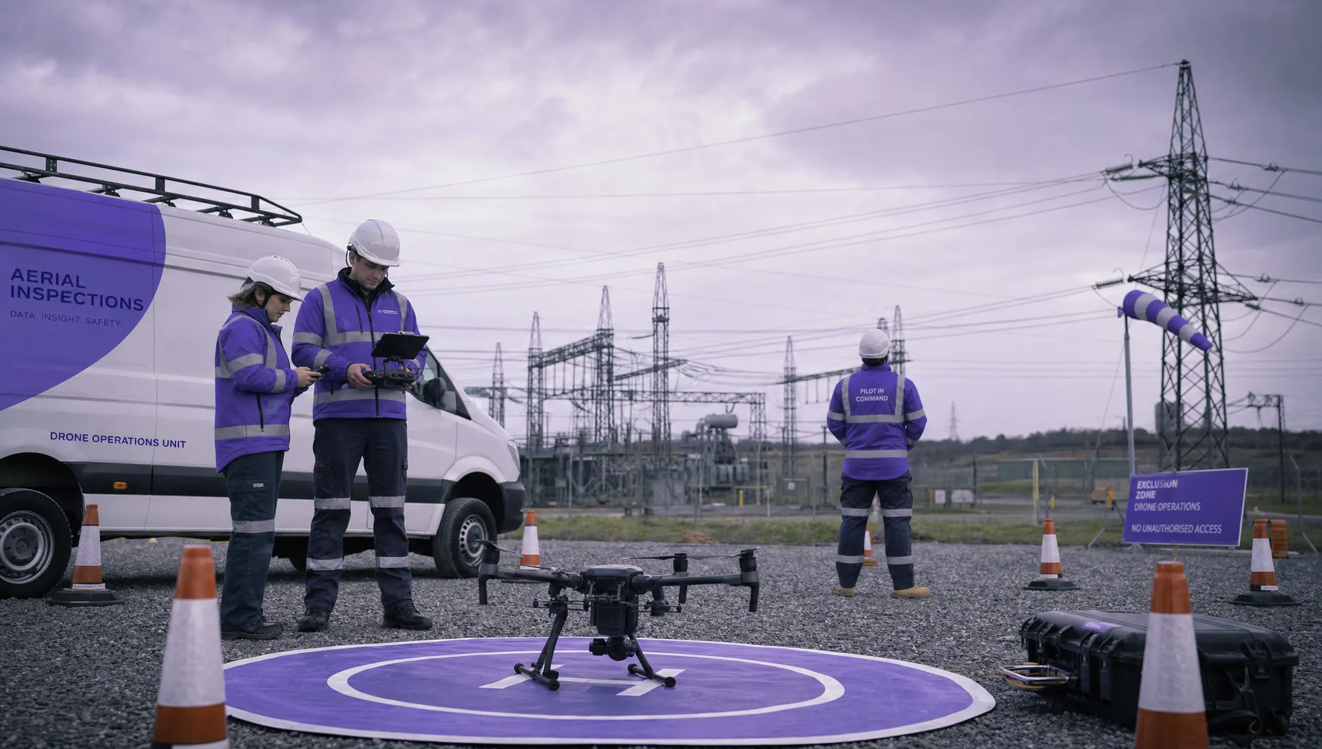
The crew consists of a remote pilot, one visual observer and a site contact. The aircraft is a multirotor drone with a camera payload. The take-off and landing area is inside the site boundary, with cones and signage used to create an exclusion zone. The client has provided site induction requirements, emergency contact details and known hazard information, including roof activity, vehicle movements and overhead services.
Before using any example like this, adjust the assumptions. A roof survey in a quiet industrial estate, a linear utilities inspection beside a live road, and a public safety deployment near crowds may all use similar risk assessment headings, but the controls and acceptance thresholds will be different.
If you want a deeper process guide before using this example, Dronedesk has a separate article on how to build a drone flight risk assessment that works.
Risk scoring method used in this example
Many organisations use a 5 by 5 risk matrix. The exact thresholds are less important than using them consistently and defining what action each score requires.
In this example, likelihood is scored from 1 to 5 and severity is scored from 1 to 5. The risk rating is likelihood multiplied by severity.
| Score range | Example level | Typical action |
|---|---|---|
| 1 to 4 | Low | Proceed if controls are in place and conditions remain as assessed |
| 5 to 9 | Medium | Proceed only with named controls, crew briefing and active monitoring |
| 10 to 16 | High | Reduce risk before flight, escalate for approval or redesign the mission |
| 17 to 25 | Unacceptable | Do not fly until the mission is changed and the risk is reduced |
This scoring method supports the ALARP principle, meaning risk should be reduced as low as reasonably practicable. The Health and Safety Executive’s ALARP guidance is a useful reference for understanding that risk controls must be proportionate, documented and defensible.
For UK operators, the risk assessment should also sit alongside the relevant requirements in the UK Civil Aviation Authority’s drone guidance, including category limits, airspace requirements, permissions and any conditions in your Operational Authorisation.
Worked drone flight risk assessment example
The table below shows a practical site-specific risk assessment for the utility inspection scenario. The numbers are illustrative, but the structure is what matters: hazard, consequence, initial risk, control measures, residual risk and owner.
| Hazard | Possible consequence | Initial risk | Control measures | Residual risk | Owner |
|---|---|---|---|---|---|
| Flight in or near controlled, restricted or temporarily restricted airspace | Airspace infringement, conflict with other aircraft, regulatory breach | 4 x 5 = 20 | Check airspace, NOTAMs, flight restrictions, nearby aerodromes and permission requirements before mobilisation and again before take-off. Do not fly without required approvals. | 1 x 5 = 5 | Remote pilot |
| Low-flying crewed aircraft, emergency helicopters or agricultural aircraft | Loss of separation or emergency landing | 3 x 5 = 15 | Maintain visual line of sight, use visual observer, brief crewed aircraft watch areas, land immediately if conflicting traffic is observed or heard. | 1 x 5 = 5 | Remote pilot and observer |
| Uninvolved people entering the operating area | Injury, distraction, loss of control, breach of separation distances | 4 x 4 = 16 | Use cones, signage, site contact and observer to maintain exclusion zone. Pause or land if people enter the area. Avoid overflight of uninvolved people. | 2 x 4 = 8 | Observer and site contact |
| Vehicle movements on access road or within site | Collision risk, driver distraction, unsafe recovery area | 3 x 4 = 12 | Position take-off area away from traffic routes, coordinate with site contact, avoid low flight over roads and pause during heavy vehicle movements. | 2 x 3 = 6 | Remote pilot |
| Overhead cables, masts and roof structures | Collision, aircraft damage, falling object risk | 4 x 4 = 16 | Conduct walk-around survey, mark obstacles on mission plan, set minimum stand-off distances, avoid flying backwards near structures, use observer for obstacle calls. | 2 x 4 = 8 | Remote pilot and observer |
| Electromagnetic interference or GNSS degradation near utility assets | Position hold instability, compass error, flyaway, inaccurate flight path | 3 x 5 = 15 | Complete compass and GNSS checks, avoid launching near large metal structures, maintain manual control readiness, stop mission if navigation warnings persist. | 2 x 4 = 8 | Remote pilot |
| Wind, gusts, rain or poor visibility | Loss of control, poor data quality, unsafe landing | 4 x 4 = 16 | Check forecast and on-site conditions, apply aircraft and company weather limits, assess gusts at take-off location and work area, delay if limits are approached. | 2 x 4 = 8 | Remote pilot |
| Battery, propulsion or payload failure | Forced landing, injury, property damage, lost data | 3 x 4 = 12 | Use pre-flight checks, inspect propellers and batteries, set return-to-home and low-battery thresholds, plan emergency landing areas, carry suitable spares. | 2 x 4 = 8 | Remote pilot |
| Loss of command link or flyaway | Aircraft leaves planned area, airspace breach, public safety risk | 3 x 5 = 15 | Confirm lost-link behaviour, set appropriate return-to-home altitude, maintain VLOS, avoid marginal signal areas and brief emergency actions. | 1 x 5 = 5 | Remote pilot |
| Site activity changes during flight | Unexpected machinery movement, roof access, people entering exclusion zone | 3 x 4 = 12 | Site contact remains available, crew pauses when work activity changes, flight only continues after re-brief and confirmation that controls remain valid. | 2 x 3 = 6 | Site contact and remote pilot |
| Pilot task fixation during inspection capture | Reduced lookout, late response to hazards, poor decision-making | 3 x 4 = 12 | Use observer, define capture priorities before take-off, keep flight segments short, call out battery and airspace checks, stop if workload becomes excessive. | 2 x 3 = 6 | Remote pilot and observer |
| Sensitive site imagery or client data exposure | Breach of client requirements, reputational damage, security issue | 3 x 3 = 9 | Confirm client data handling instructions, avoid unnecessary capture, store data securely, record who receives deliverables. | 1 x 3 = 3 | Operator or project lead |
Notice that some residual risks remain medium. That is common in professional operations. The question is not whether every risk can be reduced to zero. It is whether the remaining risk is understood, accepted by the right person, controlled on site and consistent with your authorisations and procedures.
What makes the controls credible?
A common weakness in drone risk assessments is that the control measures are too general. Phrases such as maintain awareness, follow the law or use a competent pilot may be true, but they do not show how the hazard will be controlled on that particular site.
A stronger control names the action, the person responsible and the condition that would stop the flight. For example, use observer to monitor public footpath and call stop if any person approaches the cordon is more useful than monitor public. Similarly, check NOTAMs is weaker than check NOTAMs before leaving base and again before take-off, with evidence saved in the job record.
Good controls are also measurable. If you say the drone will not fly in excessive wind, define the limit in your procedures. If you say the aircraft will avoid overhead cables, define a stand-off distance or a visual reference point. If you say a road will be protected, state whether you will avoid overflight, pause when traffic queues form or reposition the take-off area.
This is where operational maturity shows. Experienced operators do not rely on paperwork alone. They design the flight so that the safer option is also the easiest option for the crew to follow.
Dynamic risk assessment on the day
A pre-planned risk assessment is only valid if the real site still matches the assumptions. Weather, people, traffic, aircraft activity and client operations can all change between planning and take-off.
Use a short dynamic risk assessment immediately before the flight and repeat it whenever conditions change. This does not need to be complicated, but it must be deliberate.
| Change observed on site | Decision trigger | Action |
|---|---|---|
| Public footpath is busier than expected | Separation cannot be maintained | Delay, reposition, add control support or redesign the flight |
| Wind gusts are close to operational limits | Stable hover or safe landing margin is reduced | Postpone or reduce mission scope |
| Helicopter or low-flying aircraft is heard or seen | Potential conflict with crewed aviation | Descend or land, then reassess before relaunch |
| Roof contractors arrive during the inspection | People or equipment enter the work area | Pause, land if needed, re-brief with site contact |
| GNSS or compass warnings appear | Navigation reliability is uncertain | Hold only if safe, land promptly and investigate |
| Client requests extra shots outside the plan | New area has not been assessed | Stop, assess the new task, update the record before flying |
For emergency services, dynamic assessment becomes even more important because the operating environment can change in seconds. The same principle applies: record the assumptions, brief the crew, reassess continuously and stop when the risk picture changes faster than you can control it.
Minimum documentation to keep with the job
A risk assessment is most useful when it forms part of the job record, not when it sits in isolation. If there is an incident, audit or client query, you need to show what you knew, what you checked and why the flight was considered safe enough to proceed.
For a professional mission, the job pack should normally include the site-specific risk assessment, airspace and ground hazard checks, crew briefing notes, aircraft and battery checks, permissions or client approvals, weather evidence, emergency procedures and the post-flight log.
The post-flight log matters because it closes the loop. If the crew encountered unexpected GNSS interference, a busier footpath or a better emergency landing area, that learning should feed into the next assessment. Risk management improves when actual operating experience updates the template.
If you manage multiple aircraft, pilots or recurring clients, relying on scattered documents can make this harder than it needs to be. A structured system helps standardise what is checked and makes it easier to find previous job records. For operators reaching that stage, Dronedesk’s drone fleet management guide explains how fleet, team and operational records become more important as activity scales.
Turning this example into your own template
The best way to adapt this example is not to copy every hazard blindly. Instead, build a core template around hazards that appear in most missions, then add site-specific sections for the work type.
For example, a roof inspection template might include roof access, edge work by other contractors, reflective surfaces and public footpaths. A utilities template might include overhead lines, substations, electromagnetic interference, linear routes and remote emergency access. A public safety template might include cordon control, blue-light activity, public attention, night operations and multi-agency communications.
Keep the following fields consistent across all templates:
- Mission objective and location
- Crew roles and responsibilities
- Aircraft, payload and battery details
- Airspace and proximity checks
- Ground hazards and public interface
- Weather limits and observed conditions
- Emergency landing areas and lost-link settings
- Initial risk, control measures and residual risk
- Go/no-go decision and sign-off
- Post-flight notes and lessons learned
Consistency helps remote pilots brief faster, compare risk across jobs and avoid missing basic checks when under pressure. Flexibility matters too. A template should prompt good judgement, not force every mission into the same shape.
Dronedesk is built for this kind of structured workflow, with features including client management, fleet management, team management, airspace intelligence, proximity intelligence, flight planning, flight logging, data reporting, configurable checklists and risk assessments. You can review the current capabilities on the Dronedesk features page.
Common mistakes to avoid
The first mistake is treating the risk assessment as a pre-flight admin task rather than a decision tool. If the document does not influence how you set up the site, brief the crew or decide whether to fly, it is not doing its job.
The second mistake is scoring the residual risk too low without adding meaningful controls. If the initial risk is high because a public footpath is close to the operating area, the residual risk should not become low unless you have a real control such as a different take-off point, temporary access management, additional observer support or a revised flight path.
The third mistake is failing to reassess when the client changes the task. Extra images, a slightly different asset or one more quick orbit can introduce new hazards. Professional crews are comfortable saying yes, but first we need to assess it.
The fourth mistake is ignoring human factors. Fatigue, pressure from the client, time constraints, poor communication and task fixation can be just as important as wind speed or battery state. If the remote pilot is overloaded, the mission is already becoming less safe.
Frequently Asked Questions
What should a drone flight risk assessment include? It should include the mission objective, location, crew roles, aircraft details, airspace checks, ground hazards, weather conditions, emergency procedures, control measures, residual risk scoring, sign-off and post-flight notes.
Do I need a risk assessment for every drone flight? Requirements depend on the operating category, authorisations, client rules and your own procedures. Even where a formal document is not explicitly required, a recorded site-specific assessment is good professional practice for commercial and operational missions.
What is the difference between initial risk and residual risk? Initial risk is the level of risk before controls are applied. Residual risk is the level that remains after realistic control measures have been put in place and briefed to the crew.
Can I reuse the same drone risk assessment template? Yes, but only as a starting point. Reuse the structure, not the assumptions. Each site, airspace environment, client request, aircraft setup and day-of-flight condition must be checked again.
What should happen if the residual risk is still high? The mission should be redesigned, delayed, escalated for review or cancelled, depending on your procedures. High residual risk should never be accepted casually just because the job is commercially important.
Plan safer missions with a clearer workflow
A strong drone flight risk assessment example is useful, but the real value comes from making the process repeatable across every client, aircraft, pilot and mission type.
If you want to bring flight planning, risk assessments, configurable checklists, airspace intelligence, fleet records and flight logging into one operational workflow, explore Dronedesk. It helps drone teams manage the admin around safer, better documented missions without having to build a system from scratch.
 Drone Operating Rules for Managing Contractors and Employees →
 BVLOS Drone Requirements for Building a Safety Case →
 Drone Pilot Test Mistakes That Cost Candidates Marks →
 FAA 107 License vs Part 107 Certificate: What’s the Difference? →
 Drone Airport Rules: A Field Checklist for Site Assessments →
 FAA Part 107 Record-Keeping Rules for Commercial Teams →
 How to Review a DJI Flight Log After an Unexpected Event →
 Drone Laws Around the World: A Pre-Flight Research Framework →
 How to Compare Drone Survey Services for Complex Sites →
 How to Start a Drone Mapping Business With a Clear Workflow →