
Contingency Volume and Flight Risk Buffer Explained
For professional drone operators, buffers are not just neat lines on a planning map. They define where the aircraft is expected to fly, where it may safely recover from an abnormal situation and where the consequences become unacceptable.
That is why the terms contingency volume and flight risk buffer matter. They shape your flight plan, site briefing, emergency procedures, airspace assessment and operational authorisation evidence. Get them wrong and a flight that looks simple on a map can become hard to justify to a client, safety manager or regulator.
This guide explains the concepts in plain English, with a practical focus for drone operators, survey companies, utility teams and emergency services.
The short version
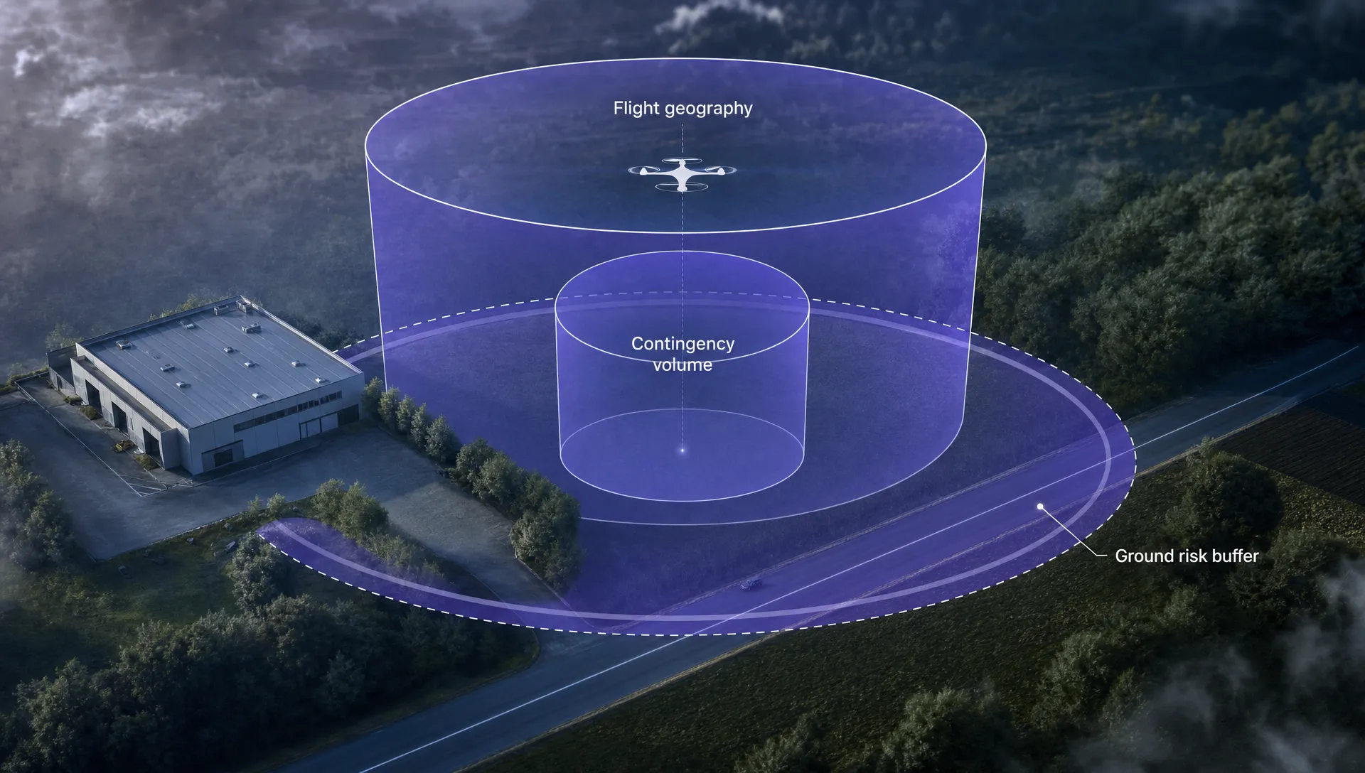
A contingency volume is the extra airspace around your planned operating area where you can apply contingency procedures if the aircraft stops behaving normally but remains recoverable.
A flight risk buffer is a practical planning margin used by many operators to reduce the chance that a drone, its route or its recovery path will create unacceptable risk. The phrase is useful in everyday operations, but it is not always the formal regulatory term. In SORA style documentation, the more precise terms are usually flight geography, contingency volume, operational volume and ground risk buffer.
| Term | Plain English meaning | Why it matters |
|---|---|---|
| Flight geography | The three dimensional area where the drone is intended to fly during normal operation | Defines the mission area, route, height and timing |
| Contingency volume | Extra airspace outside the flight geography where contingency procedures are applied | Gives the crew space to recover, hold, return or land safely |
| Operational volume | Flight geography plus contingency volume | Defines the total airspace volume used for the operation |
| Ground risk buffer | A surface area around the operational volume to reduce risk to people and property if control is lost | Helps protect uninvolved people and assets on the ground |
| Flight risk buffer | Operational shorthand for planned margins around the flight path or work area | Useful internally, but should be mapped to formal terms in safety documentation |
The key point is simple: the planned flight area is not the same thing as the safety margin around it.
Where the terminology comes from
The language around flight geography, contingency volume and ground risk buffer is closely associated with SORA, the Specific Operations Risk Assessment methodology developed by JARUS and used or adapted by aviation authorities in several jurisdictions. You will also see related language in guidance from regulators such as the UK Civil Aviation Authority and EASA.
The EASA Easy Access Rules for Unmanned Aircraft Systems separate these concepts because they deal with different types of risk. The UK CAA’s CAP 722 UAS guidance is also a key reference point for UK operators when considering operational authorisations, risk assessment and safety case expectations.
For day to day planning, you do not need to turn every small job into a regulatory thesis. You do need to show that your map, procedures and crew briefing all agree on the same thing: where the aircraft should be, what happens if it drifts outside that area and how you protect people outside the operation.
What is contingency volume?
A contingency volume is the airspace reserved for abnormal but planned-for situations. It sits outside the flight geography but inside the wider operational volume.
In normal flight, the aircraft should remain inside the flight geography. If something changes, for example stronger than forecast wind, GNSS degradation, a command latency issue or a pilot distraction, the drone may approach the boundary of that planned area. The contingency volume gives the remote pilot and crew a defined space in which to apply contingency actions before the situation becomes an emergency.
Typical contingency actions might include holding position, returning along a known route, switching to manual control, climbing or descending to a pre-briefed altitude, landing at a nominated contingency landing site or triggering a failsafe mode. The right action depends on the aircraft, location, airspace and ground risk.
A useful contingency volume has three qualities:
- It is measurable in three dimensions, not just sketched loosely around a map.
- It is linked to specific triggers, such as crossing a warning line, loss of command link for a defined time or unexpected drift.
- It is large enough for the aircraft and crew to complete the planned contingency action with a reasonable safety margin.
It is not a licence to continue the mission outside the planned operating area. If the aircraft enters the contingency volume, the mission has already moved away from normal operations. The crew should be executing the contingency procedure, not carrying on with data capture.
What is a flight risk buffer?
Flight risk buffer is a less standard phrase, but it is common in operational conversations. Different organisations use it in slightly different ways.
Some use it to mean a mapping buffer around the flight path. Others use it as a pre-flight planning margin between the aircraft and a hazard such as a road, railway, power line, building, crowd, airport boundary or sensitive site. In more formal risk assessment, the same idea may need to be broken down into contingency volume, ground risk buffer, separation distance, obstacle clearance, airspace margin or emergency landing provision.
That distinction matters when you are preparing documents for a client, internal safety review or regulator. A phrase like flight risk buffer may be clear to your team, but an external reviewer will expect to see the official risk controls and assumptions.
In practice, a flight risk buffer should answer four questions:
- How far could the aircraft move before the pilot detects and responds to the problem?
- What route or altitude will the aircraft follow during failsafe or return to home?
- What people, property, infrastructure or airspace lie beyond the planned area?
- At what point does the crew stop the task and apply a contingency or emergency procedure?
If those questions are unanswered, the buffer is just a line on a map.
Contingency volume vs ground risk buffer
The contingency volume is about airspace control during abnormal but recoverable situations. The ground risk buffer is about consequences on the surface if the aircraft leaves the operational volume or control is not recovered.
Operators sometimes combine these ideas visually, especially on simple maps. That can be fine for an internal sketch, but for more complex or higher risk operations it is better to show them separately.
| Planning element | Primary concern | Typical planning question |
|---|---|---|
| Flight geography | Normal flight | Where will the aircraft intentionally fly? |
| Contingency volume | Recoverable abnormal flight | Where can the aircraft go while the crew applies contingency procedures? |
| Ground risk buffer | Consequence of loss of control | What lies below or beyond the operational volume if recovery fails? |
| Airspace margin | Conflict with other airspace users | What separation is needed from controlled airspace, aerodromes or other aircraft activity? |
A roof survey in a quiet industrial estate may need a modest contingency volume if the aircraft is slow, close to the pilot and far from uninvolved people. A linear inspection near roads, railways and overhead lines may need more conservative margins because a lateral drift or return to home path can quickly cross into unacceptable territory.
For flights near aerodromes or controlled airspace, the buffer discussion must also include airspace constraints. Dronedesk has a separate guide on planning drone flights near airports without surprises, which is worth reading if your buffer could bring the aircraft close to an airport-related restriction.
How to size a sensible contingency volume
There is no universal distance that works for every drone operation. A fixed 10 metre or 30 metre margin might be suitable in one context and reckless in another. The volume should reflect the aircraft, pilot, site, weather, mission profile and surrounding risk.
Start with the aircraft’s performance and the task profile. A multirotor hovering for close inspection behaves very differently from a fixed-wing aircraft flying a long corridor. A slow grid survey over private land creates a different risk picture from a rapid emergency response launch close to public roads.
The main drivers are:
- Aircraft speed, mass, manoeuvrability and stopping distance
- Navigation accuracy, GNSS reliability and expected position hold performance
- Wind speed, gusts, turbulence and local effects around buildings or terrain
- Pilot reaction time, observer coverage and command link latency
- Failsafe behaviour, including return to home route, climb height and landing logic
- Obstacles, uninvolved people, roads, railways, utilities and sensitive sites
- The reliability of geofencing, telemetry alerts and crew communications
Where possible, use evidence from aircraft documentation, test flights, previous logs and manufacturer guidance. Guesswork is weak evidence. If you regularly fly similar jobs, your own flight logs can become useful support for realistic margins, provided they are maintained consistently.
For broader risk assessment structure, Dronedesk’s guide on building a drone flight risk assessment that works covers the wider assessment process. The buffer is only one part of that picture.
A practical workflow for planning buffers
A structured process prevents buffers from becoming arbitrary. The following workflow works for many commercial VLOS operations and can be adapted for more complex missions.
- Define the flight geography first: Mark the exact area, route or corridor where the drone is intended to fly. Include maximum height, minimum obstacle clearance and time window.
- Identify credible deviations: Consider drift, overshoot, lost link, wrong home point, RTH climb, pilot distraction, sensor error, battery warning and sudden weather changes.
- Choose contingency triggers: Decide what warning signs start the contingency procedure. Examples include a geofence alert, visual crossing of a map boundary, telemetry warning or loss of link for a set number of seconds.
- Size the contingency volume: Add enough lateral and vertical space for the aircraft to complete the intended contingency action. Use conservative aircraft performance data rather than a generic distance.
- Check the ground risk buffer: Look at what sits below and beyond the operational volume. Public roads, railways, schools, events and critical infrastructure may require a route change rather than a bigger buffer.
- Validate against airspace and proximity hazards: Confirm that the contingency volume and failsafe path do not enter airspace or areas you have not assessed.
- Record it in the briefing pack: The remote pilot, observers and client site contact should all understand the normal flight area, triggers, actions and no-go boundaries.
This process also helps avoid a common planning error: drawing a buffer around the mission area but forgetting that the aircraft’s automatic return or emergency landing behaviour may send it somewhere else.
Worked example: solar farm survey
Imagine a survey company planning a multirotor mapping flight over a fenced solar farm. The mission is VLOS, the site is rural and the aircraft will fly automated grid lines at a planned height agreed in the risk assessment.
The flight geography is the grid survey area, set inside the fence line with enough clearance from the panels, inverter stations and boundary obstacles. The crew then considers likely deviations. The aircraft could overshoot a turn, drift downwind at the edge of a grid, climb during return to home or pause while the pilot takes manual control.
The contingency volume is drawn around and above the flight geography to allow for those recoverable deviations. The crew does not plan to capture data there. It is the space in which they will stop the automated task, take control, hold, return or land at a nominated safe area.
The ground risk buffer is then checked against what lies outside the operational volume. If a public footpath runs close to one edge of the site, the operator might move the flight geography further inside the fence, reduce speed near the boundary, use an observer to monitor the footpath or alter the flight direction so turns happen away from the public area.
The flight risk buffer, in everyday team language, may be the combined margin the operator uses to decide whether the planned grid is acceptable. In the risk assessment, though, it is better to record the components separately so the reasoning is clear.
Worked example: utility corridor inspection
A utility company inspecting poles, pipelines or overhead lines faces a different challenge. The flight geography is often long and narrow, with hazards changing along the route. One section may cross farmland, another may run near houses, a road or railway.
A single buffer distance across the whole job may not be enough. The operator may need segmented planning, with different contingency volumes or procedures for different sections. For example, a wider contingency volume may be acceptable over open private land, but near a road the route might need to move, the aircraft speed may need to reduce or additional observers may be required.
The return to home point also becomes critical. If the aircraft loses link midway through a corridor inspection, the failsafe route could cut across areas that were not part of the original flight geography. That route needs to be assessed, not assumed safe.
This is one reason BVLOS and extended range operations demand more detailed planning. If you are exploring that area, Dronedesk’s article on what a BVLOS drone is and why it matters provides useful context before you move into more advanced risk methodology.
Common mistakes when using buffers
The most common mistake is treating a buffer as a fixed distance copied from a previous job. That creates a false sense of control. A buffer should be justified by the aircraft, environment and procedure.
Another mistake is ignoring vertical risk. Operators often draw a neat horizontal boundary on a map but forget that return to home, obstacle avoidance, turbulence or manual recovery may change altitude. In controlled airspace or near an aerodrome, vertical margins can be just as important as lateral ones.
A third mistake is failing to link the buffer to crew action. If nobody knows what to do when the drone reaches the edge of the flight geography, the contingency volume is not a practical control. It is only useful when paired with a clear trigger and rehearsed response.
Watch for these issues during planning:
- The contingency volume overlaps a hazard that has not been assessed.
- The ground risk buffer includes uninvolved people but no mitigation is recorded.
- The home point is wrong or unsuitable for the actual failsafe route.
- The crew briefing shows different boundaries from the flight plan.
- The client changes the site access plan but the buffer is not reviewed.
- Weather changes make the original drift assumptions unrealistic.
Buffers should be reviewed whenever the site, aircraft, weather, crew or mission profile changes.
How to document contingency volume and flight risk buffer decisions
Good documentation does not need to be complicated. It needs to be consistent, traceable and usable by the crew on the day.
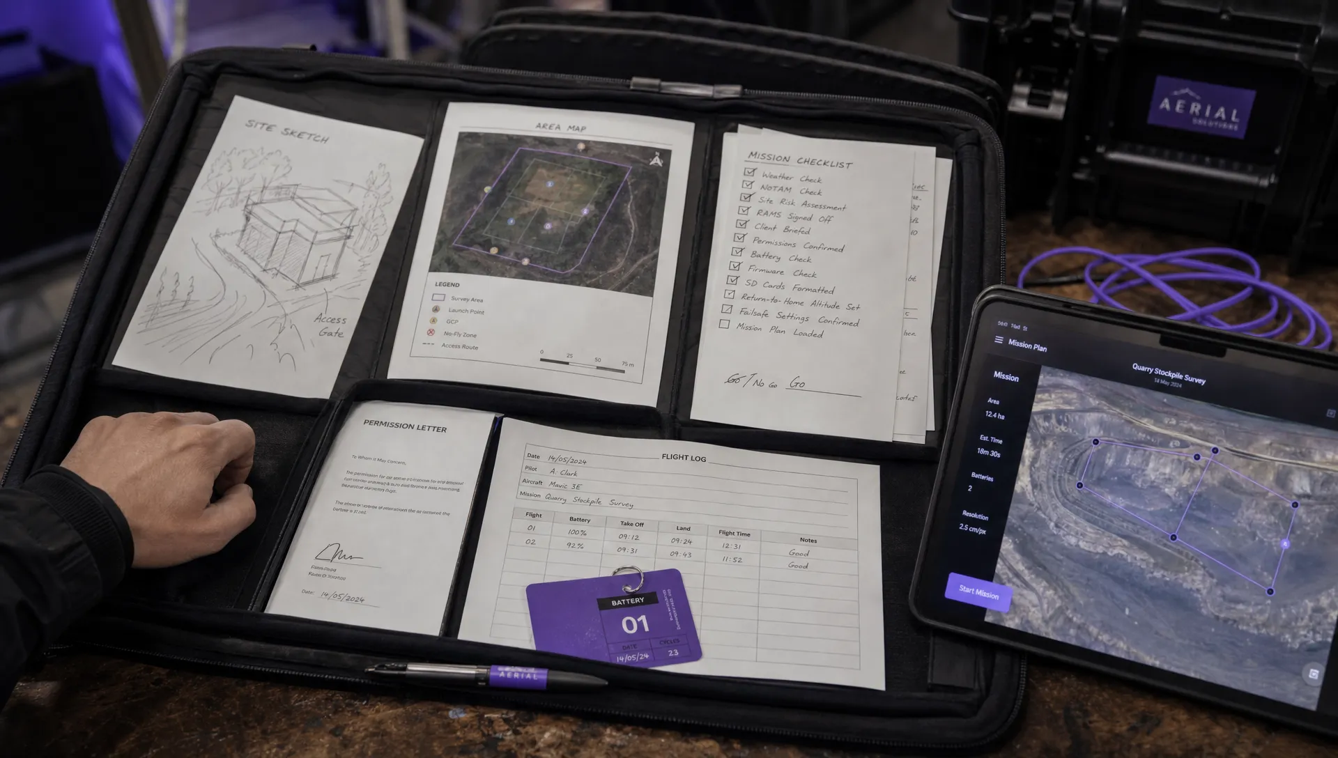
At minimum, record the normal flight geography, contingency volume, relevant ground risk buffer, planned altitude, proximity hazards, emergency landing points and contingency triggers. Add notes explaining why the buffer is suitable. For higher risk operations, include more formal evidence such as aircraft performance data, test results, site diagrams and crew role assignments.
The documentation should answer a reviewer’s likely questions:
| Reviewer question | What your documentation should show |
|---|---|
| Where is the aircraft meant to fly? | A clear flight geography with lateral and vertical limits |
| What happens if it leaves that area? | Contingency triggers and actions linked to a defined volume |
| What protects people outside the site? | Ground risk buffer, access control, observers or route changes |
| What if failsafe activates? | Assessed return route, altitude, home point and landing options |
| How will the crew know what to do? | Briefing notes, checklists, roles and communication plan |
This is where a structured operations management system helps. According to the Dronedesk features page, Dronedesk includes flight planning, airspace intelligence, proximity intelligence, configurable checklists, risk assessments, flight logging and reporting. The operator still owns the safety decision, but keeping planning, assessment, checklists and logs in one workflow makes it easier to maintain a consistent evidence trail.
How buffers affect real operational decisions
A well planned buffer can change the shape of the job. It might reduce the available survey area, alter take-off and landing locations, require extra observers or trigger a client conversation about site access control. That is not a planning failure. It is the risk assessment doing its job.
For emergency services, the balance can be more difficult. Missions may be time critical and the environment may change quickly. A pre-planned approach to contingency volume helps crews make faster decisions because they are not inventing safety margins under pressure. Standard operating procedures can define default assumptions, then the incident commander or remote pilot can adjust them based on the actual scene.
For utility and survey teams, buffers also affect data quality and productivity. A route that looks efficient in mapping software may be unsuitable if the contingency volume crosses a road or the RTH path passes over uninvolved people. Identifying that issue during planning is far cheaper than discovering it after mobilisation.
A simple rule of thumb
If you use the phrase flight risk buffer internally, define what it means before the job starts.
For a low complexity operation, it might be acceptable to say that the flight risk buffer is your agreed planning margin between the intended flight route and nearby hazards. For a higher risk or authorisation-based operation, break it into formal components: flight geography, contingency volume, operational volume and ground risk buffer.
The more complex the operation, the less you should rely on shorthand.
Frequently Asked Questions
Is contingency volume the same as flight geography? No. Flight geography is where the aircraft is intended to fly during normal operations. Contingency volume is the additional airspace where the crew applies contingency procedures if the aircraft moves outside normal expectations.
Is flight risk buffer a legal term? Not always. Many operators use it as operational shorthand, but formal SORA style documentation usually relies on terms such as contingency volume, operational volume and ground risk buffer. Use the formal terms where regulatory clarity matters.
How big should a contingency volume be? There is no single correct distance. It depends on aircraft performance, speed, navigation accuracy, wind, crew reaction time, failsafe behaviour, surrounding hazards and the planned contingency procedure.
Does a buffer make it acceptable to fly over uninvolved people? No. A buffer is a risk control, not permission to create unmanaged risk. If uninvolved people are within the relevant risk area, you need appropriate mitigation, route changes, access control or regulatory permission.
Do small VLOS jobs need contingency planning? Yes, at a proportionate level. Even simple VLOS work benefits from clear boundaries, triggers and recovery actions. The documentation may be lighter than for complex operations, but the thinking should still be present.
Should return to home be included in the buffer assessment? Yes. RTH altitude, route, home point accuracy and landing area suitability can all affect risk. A failsafe path that crosses unassessed hazards can undermine an otherwise solid flight plan.
Plan the buffer before the aircraft flies
Contingency volume and flight risk buffer planning is not paperwork for its own sake. It is how you turn a planned drone task into a controlled operation with defined limits, rehearsed actions and defensible decisions.
If your team wants a cleaner way to connect flight planning, risk assessments, checklists and logs, explore Dronedesk and see how it supports end-to-end drone operations management without losing sight of the operator’s responsibility for safe decision making.
 Drone Pilot Test Mistakes That Cost Candidates Marks →
 FAA 107 License vs Part 107 Certificate: What’s the Difference? →
 Drone Airport Rules: A Field Checklist for Site Assessments →
 FAA Part 107 Record-Keeping Rules for Commercial Teams →
 How to Review a DJI Flight Log After an Unexpected Event →
 Drone Laws Around the World: A Pre-Flight Research Framework →
 How to Compare Drone Survey Services for Complex Sites →
 How to Start a Drone Mapping Business With a Clear Workflow →
 Class C Airspace Drone Rules for Commercial Flights →
 How to Create a Drone Job Pack for Every Mission →